 |
|
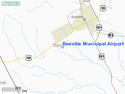
Location & QuickFacts
| FAA Information Effective: | 2008-09-25 |
| Airport Identifier: | BEA |
| Airport Status: | Operational |
| Longitude/Latitude: | 097-47-27.7064W/28-21-42.7325N
-97.791030/28.361870 (Estimated) |
| Elevation: | 268 ft / 81.69 m (Surveyed) |
| Land: | 391 acres |
| From nearest city: | 3 nautical miles SW of Beeville, TX |
| Location: | Bee County, TX |
| Magnetic Variation: | 07E (1980) |
Owner & Manager
| Ownership: | Publicly owned |
| Owner: | City Of Beeville |
| Address: | 400 N. Washington
Beeville, TX 78102 |
| Phone number: | 361-358-4641 |
| Manager: | Tim Fitch |
| Address: | 3201 Us Hwy 59 West
Beeville, TX 78102 |
| Phone number: | 361-358-0410 |
Airport Operations and Facilities
| Airport Use: | Open to public |
| Wind indicator: | Yes |
| Segmented Circle: | Yes |
| Control Tower: | No |
| Lighting Schedule: | DUSK-DAWN
ACTVT MIRL RY 12/30 - CTAF. |
| Beacon Color: | Clear-Green (lighted land airport) |
| Landing fee charge: | No |
| Sectional chart: | San Antonio |
| Region: | ASW - Southwest |
| Boundary ARTCC: | ZHU - Houston |
| Tie-in FSS: | SJT - San Angelo |
| FSS on Airport: | No |
| FSS Toll Free: | 1-800-WX-BRIEF |
| NOTAMs Facility: | BEA (NOTAM-d service avaliable) |
| Federal Agreements: | NGY |
Airport Communications
| CTAF: | 122.800 |
| Unicom: | 122.800 |
Airport Services
| Fuel available: | 100LLA |
| Bottled Oxygen: | NONE |
| Bulk Oxygen: | NONE |
Runway Information
Runway 12/30
| Dimension: | 4551 x 75 ft / 1387.1 x 22.9 m |
| Surface: | ASPH, Good Condition |
| Weight Limit: | Single wheel: 25000 lbs. |
| Edge Lights: | Medium |
| |
Runway 12 |
Runway 30 |
| Longitude: | 097-47-46.9432W | 097-47-08.4710W |
| Latitude: | 28-21-57.4993N | 28-21-27.9649N |
| Elevation: | 268.00 ft | 244.00 ft |
| Alignment: | 127 | 127 |
| Traffic Pattern: | Left | Left |
| Markings: | Non-precision instrument, Good Condition | Non-precision instrument, Good Condition |
| Crossing Height: | 20.00 ft | 26.00 ft |
| VASI: | 2-light PAPI on left side | 2-light PAPI on left side |
| Visual Glide Angle: | 3.00° | 3.00° |
| Obstruction: | 15 ft road, 345.0 ft from runway, 260 ft right of centerline, 9:1 slope to clear | 13 ft road, 300.0 ft from runway, 260 ft left of centerline, 6:1 slope to clear |
|
Runway 18/36
| Dimension: | 2530 x 60 ft / 771.1 x 18.3 m |
| Surface: | TURF, Fair Condition |
| |
Runway 18 |
Runway 36 |
| Longitude: | 097-47-34.5100W | 097-47-39.0000W |
| Latitude: | 28-22-19.7300N | 28-21-55.0000N |
| Elevation: | 269.00 ft | 269.00 ft |
| Alignment: | 127 | 9 |
| Traffic Pattern: | Left | Left |
| Obstruction: | 12 ft pline, 512.0 ft from runway, 175 ft right of centerline, 42:1 slope to clear | 30 ft pline, 600.0 ft from runway, 185 ft left of centerline, 20:1 slope to clear |
|
Radio Navigation Aids
| ID |
Type |
Name |
Ch |
Freq |
Var |
Dist |
| BEA | NDB | Beeville | | 284.00 | 07E | 0.5 nm |
| MNO | NDB | Mellon Ranch | | 375.00 | 06E | 31.4 nm |
| RKP | NDB | Rockport | | 391.00 | 06E | 42.7 nm |
| TKB | NDB | Kleberg County | | 347.00 | 06E | 48.0 nm |
| NOG | TACAN | Orange Grove | 063X | | 09E | 31.1 nm |
| ALI | VOR | Alice | | 114.50 | 06E | 39.3 nm |
| THX | VORTAC | Three Rivers | 051X | 111.40 | 08E | 20.9 nm |
| CRP | VORTAC | Corpus Christi | 102X | 115.50 | 09E | 33.1 nm |
| NGP | VORTAC | Truax | 087X | 114.00 | 06E | 48.4 nm |
Images and information placed above are from
http://www.airport-data.com/airport/BEA/
We thank them for the data!
| General Info
|
| Country |
United States
|
| State |
ARKANSAS
|
| FAA ID |
7M3
|
| Latitude |
34-31-45.338N
|
| Longitude |
093-31-37.685W
|
| Elevation |
643 feet
|
| Near City |
MOUNT IDA
|
We don't guarantee the information is fresh and accurate. The data may
be wrong or outdated.
For more up-to-date information please refer to other sources.
|
|


