 |
|
| Baytown Airport |
| IATA: HPY – ICAO: KHPY – FAA LID: HPY |
| Summary |
| Airport type |
Public |
| Owner |
Raceco Inc. |
| Serves |
Baytown, Texas |
| Elevation AMSL |
34 ft / 10 m |
| Coordinates |
29°47′10″N 094°57′10″W / 29.78611°N 94.95278°W / 29.78611; -94.95278 |
| Runways |
| Direction |
Length |
Surface |
| ft |
m |
| 14/32 |
4,334 |
1,321 |
Asphalt |
| Statistics (2004) |
| Aircraft operations |
11,700 |
| Based aircraft |
39 |
| Source: Federal Aviation Administration |
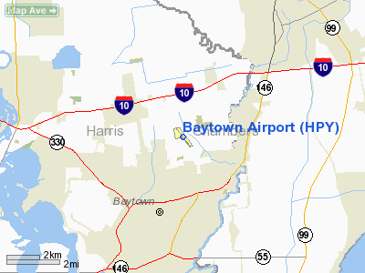
Baytown Airport (IATA: HPY, ICAO: KHPY, FAA LID: HPY) is a public-use airport located 3 nautical miles (5.6 km; 3.5 mi) north of the central business district of Baytown, a city in Harris County, Texas, United States. It is privately-owned by Raceco Inc.
Facilities and aircraft
Baytown Airport covers an area of 125 acres (51 ha) which contains one runway designated 14/32 with a 4,334 x 60 ft (1,321 x 18.288 m) asphalt surface. For the 12-month period ending October 2009, the airport had 9,490 general aviation aircraft operations, an average of 27 per day. At that time there were 27 aircraft based at the airport, including one jet and two helicopters.
In 2009 Herman Life Flight opened their new East Base on the airport property with one helicopter and crew accommodations.
The above content comes from Wikipedia and is published under free licenses – click here to read more.
Location & QuickFacts
| FAA Information Effective: | 2008-09-25 |
| Airport Identifier: | HPY |
| Airport Status: | Operational |
| Longitude/Latitude: | 094-57-09.6000W/29-47-09.9000N
-94.952667/29.786083 (Estimated) |
| Elevation: | 34 ft / 10.36 m (Surveyed) |
| Land: | 125 acres |
| From nearest city: | 3 nautical miles N of Baytown, TX |
| Location: | Harris County, TX |
| Magnetic Variation: | 05E (1995) |
Owner & Manager
| Ownership: | Privately owned |
| Owner: | Raceco Inc--baytown Arpt |
| Address: | 5600 Barkaloo Road
Baytown, TX 77520 |
| Phone number: | 281-421-1671 |
| Manager: | Gene Lander |
| Address: | 5600 Barkaloo Road
Baytown, TX 77520 |
| Phone number: | 281-421-1671 |
Airport Operations and Facilities
| Airport Use: | Open to public |
| Wind indicator: | Yes |
| Segmented Circle: | No |
| Control Tower: | No |
| Lighting Schedule: | DUSK-DAWN |
| Beacon Color: | Clear-Green (lighted land airport) |
| Landing fee charge: | No |
| Sectional chart: | Houston |
| Region: | ASW - Southwest |
| Traffic Pattern Alt: | 765 ft |
| Boundary ARTCC: | ZHU - Houston |
| Tie-in FSS: | CXO - Montgomery County |
| FSS on Airport: | No |
| FSS Toll Free: | 1-800-WX-BRIEF
FOR FP FILING CALL CXO FSS 1-800-833-5602 |
| NOTAMs Facility: | CXO (NOTAM-d service avaliable) |
Airport Communications
| CTAF: | 122.800 |
| Unicom: | 122.800 |
Airport Services
Runway Information
Runway 14/32
| Dimension: | 4334 x 50 ft / 1321.0 x 15.2 m |
| Surface: | ASPH, Fair Condition |
| Weight Limit: | Single wheel: 8000 lbs. |
| Edge Lights: | Non-standard lighting system
NSTD LIRL; LGTS 3 FT OFF PAVEMENT. INCORRECT COLOR AND SPACING. |
| |
Runway 14 |
Runway 32 |
| Longitude: | 094-57-24.5030W | 094-56-54.7290W |
| Latitude: | 29-47-26.9850N | 29-46-52.8400N |
| Elevation: | 34.00 ft | 27.00 ft |
| Alignment: | 127 | 127 |
| Traffic Pattern: | Left | Left |
| Markings: | Nonstandard, Fair Condition
14/32 MKD NPI; ALL MARKINGS ARE 1/2 SIZE IN LENGTH & WIDTH. | Nonstandard, Fair Condition |
| Displaced threshold: | 317.00 ft
THLD DSPLCD NIGHT ONLY. | 330.00 ft
THLD DSPLCD 725 FT AT NIGHT. |
| VASI: | 2-box on left side | 2-box on left side |
| Obstruction: | 32 ft trees, 200.0 ft from runway
APCH SLOPE 7:1 BASED ON NIGHT DSPLCD THLD; +15 FT HGR AT 115 FT FM DSPLCD THLD 165 FT R OF CNTRLN. 30 FT TREE 100 FT W OF EXTDD RY CNTRLN 120 FT FM THLD.
+15 FT ROAD 65 FT FM THLD 250 FT L EXTDD CNTRLN; | 20 ft pline, 200.0 ft from runway
APCH SLOPE 10:1 BASED ON DAY DSPLCD THLD; 30 FT TREE 300 FT FM DSPLCD THLD 120 FT E OF CNTRLN. APCH RATIO 0:1 BASED ON 725 FT NIGHT DSPLCD THLD; +30 FT TREE 0 FT FM NIGHT DSPLCD THLD 0 FT L OF CNTRLN.
+15-28 FT TREES & HOUSE 200 FT FM THLD 20-150 FT R OF CNTRLN; +15 FT RD 200 FT FM THLD ON CNTRLN.15 FT RD 150 FT FM THLD ACROSS THLD. 15 FT POWER POLES 130 FT FM THLD ACROSS THLD. |
|
Radio Navigation Aids
| ID |
Type |
Name |
Ch |
Freq |
Var |
Dist |
| JPA | NDB | Sanjac | | 347.00 | 05E | 9.3 nm |
| CBC | NDB | Anahuac | | 413.00 | 05E | 15.2 nm |
| BVP | NDB | Nixin | | 326.00 | 05E | 18.5 nm |
| GLS | NDB | Galveston | | 206.00 | 08E | 29.1 nm |
| SYG | NDB | Sandy Point | | 402.00 | 05E | 31.9 nm |
| EYQ | NDB | Weiser | | 286.00 | 06E | 37.0 nm |
| LYD | NDB | Lakeside | | 249.00 | 05E | 37.9 nm |
| SGR | NDB | Hull | | 388.00 | 05E | 37.9 nm |
| DWH | NDB | David Hooks | | 521.00 | 05E | 37.9 nm |
| GDE | NDB | Goodhue | | 368.00 | 07E | 42.6 nm |
| HRD | NDB | Hardin County | | 524.00 | 04E | 48.9 nm |
| EFD | TACAN | Ellington | 031X | | 05E | 15.3 nm |
| MHF | VOR/DME | Trinity | 083X | 113.60 | 07E | 18.0 nm |
| HUB | VOR/DME | Hobby | 118X | 117.10 | 05E | 18.6 nm |
| SBI | VOR/DME | Sabine Pass | 101X | 115.40 | 07E | 48.1 nm |
| BPT | VOR/DME | Beaumont | 092X | 114.50 | 07E | 49.8 nm |
| IAH | VORTAC | Humble | 113X | 116.60 | 05E | 22.9 nm |
| DAS | VORTAC | Daisetta | 116X | 116.90 | 05E | 29.1 nm |
| VUH | VORTAC | Scholes | 077X | 113.00 | 06E | 31.4 nm |
| HOU | VOT | Houston Wm P Hobby | | 108.40 | | 19.0 nm |
Remarks
- PAEW ADJ RY 14/32.
- PRE DATES THE ACT.
Images and information placed above are from
http://www.airport-data.com/airport/HPY/
We thank them for the data!
| General Info
|
| Country |
United States
|
| State |
TEXAS
|
| FAA ID |
HPY
|
| Latitude |
29-47-09.900N
|
| Longitude |
094-57-09.600W
|
| Elevation |
34 feet
|
| Near City |
BAYTOWN
|
We don't guarantee the information is fresh and accurate. The data may
be wrong or outdated.
For more up-to-date information please refer to other sources.
|
|


