 |
|
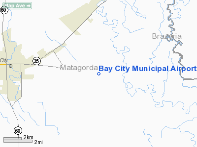
| Bay City Municipal Airport |
| IATA: BBC – ICAO: KBYY – FAA LID: BYY |
| Summary |
| Airport type |
Public |
| Owner |
City of Bay City |
| Serves |
Bay City, Texas |
| Elevation AMSL |
45 ft / 14 m |
| Coordinates |
28°58′24″N 095°51′48″W / 28.97333°N 95.86333°W / 28.97333; -95.86333 |
| Runways |
| Direction |
Length |
Surface |
| ft |
m |
| 13/31 |
5,107 |
1,557 |
Asphalt |
| Statistics (2008) |
| Aircraft operations |
8,750 |
| Based aircraft |
33 |
| Source: Federal Aviation Administration |
Bay City Municipal Airport (IATA: BBC, ICAO: KBYY, FAA LID: BYY) is a city-owned public-use airport located five nautical miles (9 km) east of the central business district of Bay City, in Matagorda County, Texas, United States.
Although most U.S. airports use the same three-letter location identifier for the FAA and IATA, this airport is assigned BYY by the FAA and BBC by the IATA. Facilities and aircraft
Bay City Municipal Airport covers an area of 140 acres (57 ha) at an elevation of 45 feet (14 m) above mean sea level. It has one runway designated 13/31 with a 5,107 by 75 ft (1,557 x 23 m) asphalt surface.
For the 12-month period ending March 27, 2008, the airport had 8,750 aircraft operations, an average of 23 per day: 99% general aviation and 1% military. At that time there were 33 aircraft based at this airport: 70% single-engine, 3% multi-engine, 6% helicopter and 21% ultralight.
Airlines and Destinations
- Air North | Vancouver [seasonal]
The above content comes from Wikipedia and is published under free licenses – click here to read more.
Location & QuickFacts
| FAA Information Effective: | 2008-09-25 |
| Airport Identifier: | BYY |
| Airport Status: | Operational |
| Longitude/Latitude: | 095-51-48.4000W/28-58-23.7000N
-95.863444/28.973250 (Estimated) |
| Elevation: | 45 ft / 13.72 m (Surveyed) |
| Land: | 140 acres |
| From nearest city: | 5 nautical miles E of Bay City, TX |
| Location: | Matagorda County, TX |
| Magnetic Variation: | 06E (1990) |
Owner & Manager
| Ownership: | Publicly owned |
| Owner: | City Of Bay City |
| Address: | City Hall 1901 5th St
Bay City, TX 77414 |
| Phone number: | 979-323-1660 |
| Manager: | Rory Hafernick |
| Address: | 3598 North Fm 2540
Bay City, TX 77414 |
| Phone number: | 979-244-5037 |
Airport Operations and Facilities
| Airport Use: | Open to public |
| Wind indicator: | Yes |
| Segmented Circle: | Yes |
| Control Tower: | No |
| Lighting Schedule: | DUSK-DAWN |
| Beacon Color: | Clear-Green (lighted land airport) |
| Landing fee charge: | No |
| Sectional chart: | Houston |
| Region: | ASW - Southwest |
| Boundary ARTCC: | ZHU - Houston |
| Tie-in FSS: | CXO - Montgomery County |
| FSS on Airport: | No |
| FSS Toll Free: | 1-800-WX-BRIEF |
| NOTAMs Facility: | BYY (NOTAM-d service avaliable) |
| Federal Agreements: | NGY |
Airport Communications
| CTAF: | 122.800 |
| Unicom: | 122.800 |
Airport Services
| Fuel available: | 100LLA |
| Airframe Repair: | MAJOR |
| Power Plant Repair: | MAJOR |
Runway Information
Runway 13/31
| Dimension: | 5107 x 75 ft / 1556.6 x 22.9 m |
| Surface: | ASPH, Good Condition |
| Weight Limit: | Single wheel: 30000 lbs.
Dual wheel: 51000 lbs.
Dual tandem wheel: 82000 lbs. |
| Edge Lights: | Medium |
| |
Runway 13 |
Runway 31 |
| Longitude: | 095-52-09.2606W | 095-51-27.5955W |
| Latitude: | 28-58-41.1098N | 28-58-06.2646N |
| Elevation: | 44.00 ft | 40.00 ft |
| Alignment: | 127 | 127 |
| Traffic Pattern: | Left | Left |
| Markings: | Non-precision instrument, Good Condition | Non-precision instrument, Good Condition |
| Crossing Height: | 24.00 ft | 0.00 ft |
| VASI: | 2-light PAPI on left side | |
| Visual Glide Angle: | 3.50° | 0.00° |
| Runway End Identifier: | Yes | |
| Obstruction: | 10 ft brush, 220.0 ft from runway, 200 ft left of centerline, 2:1 slope to clear
10 FT TALL BRUSH INSIDE THE PRIMARY SFC AREA STARTING AT APPROX. 160 FT FM RY END OUT TO 200 FT, FM 200-250 FT LEFT OF THE APCH PATH. | , 50:1 slope to clear |
|
Radio Navigation Aids
| ID |
Type |
Name |
Ch |
Freq |
Var |
Dist |
| BYY | NDB | Bay City | | 344.00 | 06E | 0.2 nm |
| ARM | NDB | Wharton | | 245.00 | 06E | 22.7 nm |
| SYG | NDB | Sandy Point | | 402.00 | 05E | 38.0 nm |
| SGR | NDB | Hull | | 388.00 | 05E | 41.1 nm |
| PKV | NDB | Port Lavaca | | 515.00 | 05E | 47.2 nm |
| ELA | VOR/DME | Eagle Lake | 111X | 116.40 | 08E | 47.8 nm |
| PSX | VORTAC | Palacios | 120X | 117.30 | 08E | 26.5 nm |
Remarks
- TWY REFLECTORS ON ALL TWYS.
Images and information placed above are from
http://www.airport-data.com/airport/BYY/
We thank them for the data!
| General Info
|
| Country |
United States
|
| State |
TEXAS
|
| FAA ID |
BYY
|
| Time |
UTC-6(-5DT)
|
| Latitude |
28.973256
28° 58' 23.72" N
|
| Longitude |
-95.863456
095° 51' 48.44" W
|
| Elevation |
45 feet
14 meters
|
| Type |
Civil
|
| Magnetic Variation |
004° E (01/06)
|
| Beacon |
Yes
|
| Operating Agency |
U.S.CIVIL AIRPORT WHEREIN PERMIT COVERS USE BY TRANSIT MILITARY AIRCRAFT
|
| Operating Hours |
SEE REMARKS FOR OPERATING HOURS OR COMMUNICATIONS FOR POSSIBLE HOURS
|
| Daylight Saving Time |
Second Sunday in March at 0200 to first Sunday in November at 0200 local time (Exception Arizona and that portion of Indiana in the Eastern Time Zone)
|
We don't guarantee the information is fresh and accurate. The data may
be wrong or outdated.
For more up-to-date information please refer to other sources.
|
|


