 |
|
Alpine-casparis Muni Airport |
| Alpine-Casparis Municipal Airport |
| IATA: ALE – ICAO: none – FAA LID: E38 |
| Summary |
| Airport type |
Public |
| Owner |
City of Alpine |
| Serves |
Alpine, Texas |
| Elevation AMSL |
4,515 ft / 1,376 m |
| Coordinates |
30°23′03″N 103°41′01″W / 30.38417°N 103.68361°W / 30.38417; -103.68361 |
| Runways |
| Direction |
Length |
Surface |
| ft |
m |
| 1/19 |
6,003 |
1,830 |
Asphalt |
| 5/23 |
5,018 |
1,529 |
Asphalt |
| Statistics (2006) |
| Aircraft operations |
9,350 |
| Based aircraft |
32 |
| Source: Federal Aviation Administration |
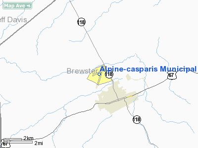
Alpine-Casparis Municipal Airport (IATA: ALE, FAA LID: E38) is a city-owned public-use airport located two miles (3 km) northwest of the central business district of Alpine, a city in Brewster County, Texas, United States. It supports two small runways, and is not meant for large commercial planes. Alpine-Casparis is the only airport in Brewster County, and provides air services to most of the area.
The airport provides Alpine with a modest sum of money. Being the only airport in the general area, and very close to the largest city in the county, makes it an adequate stop for small commercial or private aircraft. It is not uncommon for the airport's three hangars to be full during the summer, when air travel in the area is at its highest. Alpine-Casparis Municipal Airport earns the city about $908,000 a year. The airport provides 17 jobs to the city, and has an average of 2100 patrons annually. The airport itself is used for recreational flying, flight training, small cargo shipping, refuelling stops, and medical flights.
On July 4, 2010, a twin-engine Cessna 421 employed by O’Hara Flying Service II LP of Amarillo as an air ambulance, was en route to Midland, Texas when it crashed in a field one mile east of Alpine-Casparis Municipal Airport, killing all 5 on board.
Facilities and aircraft
Alpine-Casparis Municipal Airport covers an area of 196 acres (79 ha) which contains two asphalt paved runways: 1/19 measuring 6,003 x 75 ft (1,830 x 23 m) and 5/23 measuring 5,018 x 60 ft (1,529 x 18 m).
For the 12-month period ending July 22, 2006, the airport had 9,350 aircraft operations, an average of 25 per day: 99% general aviation and 1% military. There are 32 aircraft based at this airport: 91% single-engine, 6% multi-engine and 3% helicopter.
The above content comes from Wikipedia and is published under free licenses – click here to read more.
Location & QuickFacts
| FAA Information Effective: | 2008-09-25 |
| Airport Identifier: | E38 |
| Airport Status: | Operational |
| Longitude/Latitude: | 103-41-00.9000W/30-23-03.2000N
-103.683583/30.384222 (Estimated) |
| Elevation: | 4515 ft / 1376.17 m (Surveyed) |
| Land: | 196 acres |
| From nearest city: | 2 nautical miles NW of Alpine, TX |
| Location: | Brewster County, TX |
| Magnetic Variation: | 09E (1990) |
Owner & Manager
| Ownership: | Publicly owned |
| Owner: | City Of Alpine |
| Address: | 100 N. 13th Street
Alpine, TX 79830 |
| Phone number: | 432-837-3301 |
| Manager: | Chuy Garcia
CITY MANAGER. |
| Address: | 100 N. 13th Street
Alpine, TX 79830 |
| Phone number: | 432-837-3301 |
Airport Operations and Facilities
| Airport Use: | Open to public |
| Wind indicator: | Yes |
| Segmented Circle: | Yes |
| Control Tower: | No |
| Lighting Schedule: | DUSK-DAWN
MIRL RYS 01/19 & 05/23 PRESET LOW INTST; TO INCR INTST ACTVT - CTAF. |
| Beacon Color: | Clear-Green (lighted land airport) |
| Landing fee charge: | No |
| Sectional chart: | El Paso |
| Region: | ASW - Southwest |
| Boundary ARTCC: | ZAB - Albuquerque |
| Tie-in FSS: | SJT - San Angelo |
| FSS on Airport: | No |
| FSS Toll Free: | 1-800-WX-BRIEF |
| NOTAMs Facility: | E38 (NOTAM-d service avaliable) |
| Federal Agreements: | NGY |
Airport Communications
| CTAF: | 122.800 |
| Unicom: | 122.800 |
Airport Services
| Fuel available: | 100LLA |
| Airframe Repair: | MAJOR |
| Power Plant Repair: | MAJOR |
| Bottled Oxygen: | NONE |
| Bulk Oxygen: | NONE |
Runway Information
Runway 01/19
| Dimension: | 6003 x 75 ft / 1829.7 x 22.9 m |
| Surface: | ASPH, Good Condition |
| Weight Limit: | Single wheel: 12500 lbs. |
| Edge Lights: | Medium |
| |
Runway 01 |
Runway 19 |
| Longitude: | 103-41-12.2589W | 103-40-45.8472W |
| Latitude: | 30-22-31.4550N | 30-23-26.2618N |
| Elevation: | 4515.00 ft | 4450.00 ft |
| Alignment: | 23 | 127 |
| Traffic Pattern: | Left | Left |
| Markings: | Non-precision instrument, Good Condition | Non-precision instrument, Good Condition |
| Crossing Height: | 27.00 ft | 27.00 ft |
| VASI: | 2-box on left side | 2-box on left side |
| Visual Glide Angle: | 3.50° | 4.00° |
| Obstruction: | 7 ft tree, 245.0 ft from runway, 170 ft right of centerline, 6:1 slope to clear
10 FT BRUSH 130 FT FM END AND 75 FT RIGHT OF CENTERLINE. | 4 ft fence, 300.0 ft from runway, 25:1 slope to clear
3 FT BRUSH 0-200 FT FM THLD 75-240 FT RIGHT. |
|
Runway 05/23
| Dimension: | 5018 x 60 ft / 1529.5 x 18.3 m |
| Surface: | ASPH, Good Condition |
| Weight Limit: | Single wheel: 12500 lbs. |
| Edge Lights: | Medium |
| |
Runway 05 |
Runway 23 |
| Longitude: | 103-41-28.3938W | 103-40-37.9640W |
| Latitude: | 30-22-56.5405N | 30-23-20.0728N |
| Elevation: | 4510.00 ft | 4448.00 ft |
| Alignment: | 62 | 127 |
| Traffic Pattern: | Left | Left |
| Markings: | Non-precision instrument, Good Condition | Non-precision instrument, Good Condition |
| Obstruction: | 4 ft brush, 215.0 ft from runway, 96 ft left of centerline, 3:1 slope to clear | 15 ft road, 524.0 ft from runway, 21:1 slope to clear |
|
Radio Navigation Aids
| ID |
Type |
Name |
Ch |
Freq |
Var |
Dist |
| BWR | NDB | Brewster County | | 412.00 | 09E | 4.8 nm |
| IMP | NDB | Marathon | | 388.00 | 10E | 24.3 nm |
| MRF | VOR/DME | Marfa | 106X | 115.90 | 11E | 15.0 nm |
Images and information placed above are from
http://www.airport-data.com/airport/E38/
We thank them for the data!
| General Info
|
| Country |
United States
|
| State |
TEXAS
|
| FAA ID |
E38
|
| Latitude |
30-23-03.200N
|
| Longitude |
103-41-00.900W
|
| Elevation |
4515 feet
|
| Near City |
ALPINE
|
We don't guarantee the information is fresh and accurate. The data may
be wrong or outdated.
For more up-to-date information please refer to other sources.
|
|


