 |
|
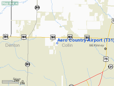
Location & QuickFacts
| FAA Information Effective: | 2008-09-25 |
| Airport Identifier: | T31 |
| Airport Status: | Operational |
| Longitude/Latitude: | 096-44-30.9880W/33-12-30.4200N
-96.741941/33.208450 (Estimated) |
| Elevation: | 792 ft / 241.40 m (Estimated) |
| Land: | 36 acres |
| From nearest city: | 4 nautical miles W of Mc Kinney, TX |
| Location: | Collin County, TX |
| Magnetic Variation: | 06E (1985) |
Owner & Manager
| Ownership: | Privately owned |
| Owner: | Aero Country Property
OWNERS ASSOCIATION. |
| Address: | 255 Aero Country Rd
Mc Kinney, TX 75071 |
| Phone number: | 972-346-2646 |
| Manager: | Art Jones |
| Address: | 255 Aero Country Rd
Mc Kinney, TX 75071 |
| Phone number: | 972-346-2646
ART JONES CTC PERSON FOR OWNERS ASSOCIATION. |
Airport Operations and Facilities
| Airport Use: | Open to public |
| Wind indicator: | Yes |
| Segmented Circle: | Yes |
| Control Tower: | No |
| Lighting Schedule: | RDO-CTL
ACTVT LIRL RY 17/35 - CTAF. |
| Sectional chart: | Dallas-ft Worth |
| Region: | ASW - Southwest |
| Boundary ARTCC: | ZFW - Fort Worth |
| Tie-in FSS: | FTW - Fort Worth |
| FSS on Airport: | No |
| FSS Phone: | 817-541-3474 |
| FSS Toll Free: | 1-800-WX-BRIEF |
| NOTAMs Facility: | FTW (NOTAM-d service avaliable) |
Airport Communications
Airport Services
| Airframe Repair: | MAJOR |
| Power Plant Repair: | MAJOR |
Runway Information
Runway 17/35
| Dimension: | 4305 x 40 ft / 1312.2 x 12.2 m |
| Surface: | ASPH-TURF, Good Condition
SOUTH END ASPH 2950 FT; NORTH END TURF 1355 FT. |
| Edge Lights: | Non-standard lighting system
NSTD LIRL; EDGE LGTS SPACING 300 FT APART. |
| |
Runway 17 |
Runway 35 |
| Traffic Pattern: | Left | Left |
| Markings: | Nonstandard, Good Condition
17/35 NSTD NRS ONLY - 20 FT TALL. | Nonstandard, Good Condition |
| Displaced threshold: | 300.00 ft | 245.00 ft |
| Obstruction: | 4 ft fence
APCH RATIO 5:1 FM 53 FT TREES 300 FT FM DSPLCD THLD 81 FT L. | 27 ft trees, 615.0 ft from runway, 160 ft right of centerline, 15:1 slope to clear
APCH RATIO 31:1 FM 27 FT TREES 860 FT FM DSPLCD THLD 160 FT R.
PAVED ROAD ACROSS APCH AT 40 FT FM THLD; SLOPE IS 19:1 AT DSPLCD THLD. |
|
Radio Navigation Aids
| ID |
Type |
Name |
Ch |
Freq |
Var |
Dist |
| PQF | NDB | Mesquite | | 248.00 | 06E | 26.3 nm |
| MII | NDB | Caddo Mills | | 316.00 | 06E | 26.8 nm |
| RBD | NDB | Redbird | | 287.00 | 06E | 32.6 nm |
| JUG | NDB | Jecca | | 388.00 | 06E | 34.2 nm |
| SYW | NDB | Cash | | 428.00 | 05E | 36.6 nm |
| AVZ | NDB | Travis | | 260.00 | 06E | 36.7 nm |
| DNI | NDB | Denison | | 341.00 | 06E | 37.2 nm |
| HJM | NDB | Rayburn | | 415.00 | 06E | 37.4 nm |
| LNC | NDB | Lancaster | | 239.00 | 06E | 37.9 nm |
| GLE | NDB | Gainesville | | 330.00 | 06E | 38.3 nm |
| XQH | NDB | Cedar Hill | | 353.00 | 08E | 38.9 nm |
| DUA | NDB | Durant | | 359.00 | 05E | 47.3 nm |
| MJF | TACAN | Arvilla | 033X | | 05E | 35.3 nm |
| NFW | TACAN | Nas Jrb Fort Worth | 024X | | 07E | 43.9 nm |
| CVE | VOR/DME | Cowboy | 109X | 116.20 | 06E | 20.8 nm |
| TTT | VOR/DME | Maverick | 078X | 113.10 | 06E | 25.3 nm |
| URH | VOR/DME | Texoma | 090X | 114.30 | 05E | 47.6 nm |
| FUZ | VORTAC | Ranger | 104X | 115.70 | 06E | 29.2 nm |
| BYP | VORTAC | Bonham | 093X | 114.60 | 06E | 32.3 nm |
| DAL | VOT | Dallas Love Field | | 113.30 | | 22.4 nm |
| FTW | VOT | Fort Worth Meacham | | 108.20 | | 39.0 nm |
Remarks
- STEEP DOWNSLOPE 50' EAST OF CNTRLN NEAR NORTH END.
- NO NIGHT LNDGS AFT 2200.
- NO TRANSIENT TOUCH AND GO.
- LOOSE GRVL ON RY & TWYS.
- ARPT CLSD TO TRANSIENT FLIGHT TRNG.
- PILOTS ARE ADVISED OF NON-AERONAUTICAL USES OF HANGAR AREA WITH VEHICLE TRAFFIC IN ALL AREAS.
- FUEL AVBL FOR EMERGENCIES.
- CLEAR 20-1 APPROACHES.
Images and information placed above are from
http://www.airport-data.com/airport/T31/
We thank them for the data!
| General Info
|
| Country |
United States
|
| State |
TEXAS
|
| FAA ID |
T31
|
| Latitude |
33-12-30.420N
|
| Longitude |
096-44-30.988W
|
| Elevation |
792 feet
|
| Near City |
MC KINNEY
|
We don't guarantee the information is fresh and accurate. The data may
be wrong or outdated.
For more up-to-date information please refer to other sources.
|
|


