 |
|
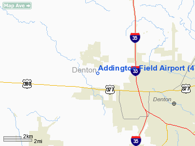
Location & QuickFacts
| FAA Information Effective: | 2008-09-25 |
| Airport Identifier: | 4TX8 |
| Airport Status: | Operational |
| Longitude/Latitude: | 097-13-26.0590W/33-14-55.4250N
-97.223905/33.248729 (Estimated) |
| Elevation: | 705 ft / 214.88 m (Estimated) |
| Land: | 0 acres |
| From nearest city: | 1 nautical miles SE of Krum, TX |
| Location: | Denton County, TX |
| Magnetic Variation: | 07E (1985) |
Owner & Manager
| Ownership: | Privately owned |
| Owner: | James T Addington |
| Address: | 3201 Montecito Rd
Denton, TX 76205 |
| Phone number: | 817-382-3150 |
| Manager: | James T. Addington |
| Address: | 3201 Montecito Rd
Denton, TX 76205 |
| Phone number: | 817-382-3150 |
Airport Operations and Facilities
| Airport Use: | Private |
| Wind indicator: | Yes |
| Segmented Circle: | No |
| Control Tower: | No |
| Landing fee charge: | No |
| Sectional chart: | Dallas-ft Worth |
| Region: | ASW - Southwest |
| Boundary ARTCC: | ZFW - Fort Worth |
| Tie-in FSS: | FTW - Fort Worth |
| FSS on Airport: | No |
| FSS Phone: | 817-541-3474 |
| FSS Toll Free: | 1-800-WX-BRIEF |
Airport Services
| Airframe Repair: | NONE |
| Power Plant Repair: | NONE |
Runway Information
Runway 17/35
| Dimension: | 2600 x 100 ft / 792.5 x 30.5 m
250' OVERRUN SOUTH END; 500' OVERRUN NORTH END. |
| Surface: | TURF, |
| |
Runway 17 |
Runway 35 |
| Traffic Pattern: | Left | Left |
| Obstruction: | | 40 ft pline, 300.0 ft from runway |
|
Radio Navigation Aids
| ID |
Type |
Name |
Ch |
Freq |
Var |
Dist |
| GLE | NDB | Gainesville | | 330.00 | 06E | 28.3 nm |
| GMZ | NDB | Grindstone Mountain | | 356.00 | 07E | 34.9 nm |
| RBD | NDB | Redbird | | 287.00 | 06E | 38.7 nm |
| XQH | NDB | Cedar Hill | | 353.00 | 08E | 41.4 nm |
| PQF | NDB | Mesquite | | 248.00 | 06E | 43.9 nm |
| DNI | NDB | Denison | | 341.00 | 06E | 44.3 nm |
| LNC | NDB | Lancaster | | 239.00 | 06E | 47.6 nm |
| JUG | NDB | Jecca | | 388.00 | 06E | 49.3 nm |
| NFW | TACAN | Nas Jrb Fort Worth | 024X | | 07E | 30.7 nm |
| TTT | VOR/DME | Maverick | 078X | 113.10 | 06E | 24.6 nm |
| CVE | VOR/DME | Cowboy | 109X | 116.20 | 06E | 26.9 nm |
| FUZ | VORTAC | Ranger | 104X | 115.70 | 06E | 21.7 nm |
| UKW | VORTAC | Bowie | 071X | 112.40 | 06E | 34.6 nm |
| FTW | VOT | Fort Worth Meacham | | 108.20 | | 26.8 nm |
| DAL | VOT | Dallas Love Field | | 113.30 | | 30.6 nm |
Images and information placed above are from
http://www.airport-data.com/airport/4TX8/
We thank them for the data!
| General Info
|
| Country |
United States
|
| State |
TEXAS
|
| FAA ID |
4TX8
|
| Latitude |
33-14-55.425N
|
| Longitude |
097-13-26.059W
|
| Elevation |
705 feet
|
| Near City |
KRUM
|
We don't guarantee the information is fresh and accurate. The data may
be wrong or outdated.
For more up-to-date information please refer to other sources.
|
|


