 |
|
| Abernathy Municipal Airport |
 |
| IATA: none – ICAO: none – FAA LID: F83 |
| Summary |
| Airport type |
Public |
| Operator |
City of Abernathy |
| Serves |
Abernathy |
| Location |
Hale County, near Abernathy, Texas |
| Elevation AMSL |
1,014 m / 3,327 ft |
| Coordinates |
33°50′45.29″N 101°45′46.6″W / 33.8459139°N 101.762944°W / 33.8459139; -101.762944 |
| Runways |
| Direction |
Length |
Surface |
| m |
ft |
03/21 |
986 |
3,325 |
Asphalt |
| 17/35 |
1,219 |
4,000 |
Asphalt |
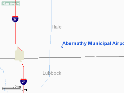
The Abernathy Municipal Airport (FAA LID: F83) is a general-aviation airport that is located 4 miles east of Abernathy, Texas. The airport is currently (as of September 2009) owned and operated by the city of Abernathy, Texas. History
The Abernathy Municipal Airport was built during World War II and opened in November 1943 as Abernathy Auxiliary Field by the United States Army Air Forces as a auxiliary field for nearby Lubbock Army Air Field and South Plains Army Air Field. The field was initially built for use by Lubbock Army Air Field, but following the activation of South Plains Army Air Field, was assigned to that base. In 1944 after the conclusion of training operations at South Plains Army Air Field, Abernathy reverted to Lubbock Army Air Field for the duration of the war. At the end of WWII, The United States military maintained over 5,600 bases stateside and around the world. The field was declared surplus and released to the War Assets Administration for disposal. The field was given to the City of Abernanthy for use as a civil airport.
The above content comes from Wikipedia and is published under free licenses – click here to read more.
Location & QuickFacts
| FAA Information Effective: | 2008-09-25 |
| Airport Identifier: | F83 |
| Airport Status: | Operational |
| Longitude/Latitude: | 101-45-46.6120W/33-50-45.2890N
-101.762948/33.845914 (Estimated) |
| Elevation: | 3327 ft / 1014.07 m (Surveyed) |
| Land: | 640 acres |
| From nearest city: | 4 nautical miles E of Abernathy, TX |
| Location: | Hale County, TX |
| Magnetic Variation: | 09E (1985) |
Owner & Manager
| Ownership: | Publicly owned |
| Owner: | City Of Abernathy |
| Address: | Po Box 310
Abernathy, TX 79311 |
| Phone number: | 806-298-2546 |
| Manager: | Mike Cypert, City Mgr |
| Address: | Po Box 310
Abernathy, TX 79311 |
| Phone number: | 806-298-2546
EMERGENCY 806-298-2545. |
Airport Operations and Facilities
| Airport Use: | Open to public |
| Wind indicator: | Yes |
| Segmented Circle: | Yes |
| Control Tower: | No |
| Lighting Schedule: | DUSK-DAWN
MIRL RY 17/35 PRESET LOW INTST; TO INCR INTST ACTVT - 122.8. |
| Beacon Color: | Clear-Green (lighted land airport) |
| Landing fee charge: | No |
| Sectional chart: | Dallas-ft Worth |
| Region: | ASW - Southwest |
| Boundary ARTCC: | ZFW - Fort Worth |
| Tie-in FSS: | FTW - Fort Worth |
| FSS on Airport: | No |
| FSS Phone: | 817-541-3474 |
| FSS Toll Free: | 1-800-WX-BRIEF |
| NOTAMs Facility: | FTW (NOTAM-d service avaliable) |
| Federal Agreements: | P |
Airport Communications
| CTAF: | 122.800 |
| Unicom: | 122.800
UNICOM UNMONITORED. |
Airport Services
| Bottled Oxygen: | NONE |
| Bulk Oxygen: | NONE |
Runway Information
Runway 17/35
| Dimension: | 4000 x 75 ft / 1219.2 x 22.9 m |
| Surface: | ASPH, Good Condition |
| Weight Limit: | Single wheel: 8000 lbs. |
| Edge Lights: | Medium |
| |
Runway 17 |
Runway 35 |
| Traffic Pattern: | Left | Right |
| Markings: | Basic, Good Condition | Basic, Good Condition |
| Obstruction: | 15 ft road, 786.0 ft from runway, 39:1 slope to clear | 12 ft road, 491.0 ft from runway, 24:1 slope to clear |
|
Radio Navigation Aids
| ID |
Type |
Name |
Ch |
Freq |
Var |
Dist |
| CZX | NDB | Crosbyton | | 332.00 | 09E | 29.4 nm |
| LIU | NDB | Littlefield | | 212.00 | 10E | 31.4 nm |
| LLN | NDB | Levelland | | 266.00 | 09E | 35.2 nm |
| BFE | NDB | Brownfield | | 311.00 | 09E | 45.5 nm |
| PVW | VOR/DME | Plainview | 076X | 112.90 | 11E | 14.5 nm |
| LBB | VORTAC | Lubbock | 029X | 109.20 | 11E | 11.3 nm |
Images and information placed above are from
http://www.airport-data.com/airport/F83/
We thank them for the data!
| General Info
|
| Country |
United States
|
| State |
TEXAS
|
| FAA ID |
F83
|
| Latitude |
33-50-45.289N
|
| Longitude |
101-45-46.612W
|
| Elevation |
3327 feet
|
| Near City |
ABERNATHY
|
We don't guarantee the information is fresh and accurate. The data may
be wrong or outdated.
For more up-to-date information please refer to other sources.
|
|


