 |
|
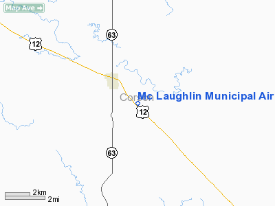
Location & QuickFacts
| FAA Information Effective: | 2008-09-25 |
| Airport Identifier: | 5P2 |
| Airport Status: | Operational |
| Longitude/Latitude: | 100-47-03.3010W/45-47-48.5100N
-100.784250/45.796808 (Estimated) |
| Elevation: | 2006 ft / 611.43 m (Surveyed) |
| Land: | 69 acres |
| From nearest city: | 2 nautical miles SE of Mc Laughlin, SD |
| Location: | Corson County, SD |
| Magnetic Variation: | 09E (1995) |
Owner & Manager
| Ownership: | Publicly owned |
| Owner: | City Of Mc Laughlin |
| Address: | Po Box 392
Mc Laughlin, SD 57642 |
| Phone number: | 605-823-4428 |
| Manager: | Lornie Hach |
| Address: | Po Box 392
Mc Laughlin, SD 57642 |
| Phone number: | 605-823-4428 |
Airport Operations and Facilities
| Airport Use: | Open to public |
| Wind indicator: | Yes |
| Segmented Circle: | Yes |
| Control Tower: | No |
| Lighting Schedule: | DUSK-DAWN
ACTVT LIRL RY 13/31 - CTAF. |
| Beacon Color: | Clear-Green (lighted land airport) |
| Landing fee charge: | No |
| Sectional chart: | Twin Cities |
| Region: | AGL - Great Lakes |
| Boundary ARTCC: | ZMP - Minneapolis |
| Tie-in FSS: | HON - Huron |
| FSS on Airport: | No |
| FSS Toll Free: | 1-800-WX-BRIEF |
| NOTAMs Facility: | HON (NOTAM-d service avaliable) |
| Federal Agreements: | NGY |
Airport Communications
| CTAF: | 122.800 |
| Unicom: | 122.800 |
Airport Services
| Airframe Repair: | MAJOR |
| Power Plant Repair: | MAJOR |
| Bottled Oxygen: | NONE |
| Bulk Oxygen: | NONE |
Runway Information
Runway 13/31
| Dimension: | 3800 x 60 ft / 1158.2 x 18.3 m |
| Surface: | ASPH, Good Condition
RWY SURFACE IS OILED CHIP SEAL. |
| Surface Treatment: | Aggregate Friction Seal Coat |
| Weight Limit: | Single wheel: 12500 lbs. |
| Edge Lights: | Low |
| |
Runway 13 |
Runway 31 |
| Longitude: | 100-47-20.6890W | 100-46-45.9130W |
| Latitude: | 45-48-02.7910N | 45-47-34.2290N |
| Elevation: | 1996.00 ft | 1999.00 ft |
| Alignment: | 127 | 127 |
| Traffic Pattern: | Left | Left |
| Markings: | Basic, Good Condition | Basic, Good Condition |
| Runway End Identifier: | No | No |
| Centerline Lights: | No | No |
| Touchdown Lights: | No | No |
| Obstruction: | 1 ft fence, 220.0 ft from runway, 20:1 slope to clear | , 50:1 slope to clear |
|
Radio Navigation Aids
| ID |
Type |
Name |
Ch |
Freq |
Var |
Dist |
| RVB | NDB | Riverbend | | 407.00 | 09E | 21.6 nm |
Images and information placed above are from
http://www.airport-data.com/airport/5P2/
We thank them for the data!
| General Info
|
| Country |
United States
|
| State |
SOUTH DAKOTA
|
| FAA ID |
5P2
|
| Latitude |
45-47-48.510N
|
| Longitude |
100-47-03.301W
|
| Elevation |
2006 feet
|
| Near City |
MC LAUGHLIN
|
We don't guarantee the information is fresh and accurate. The data may
be wrong or outdated.
For more up-to-date information please refer to other sources.
|
|


