 |
|
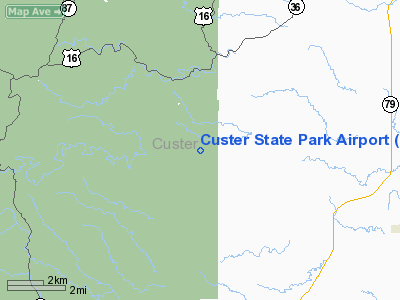
Custer State Park Airport |
Location & QuickFacts
| FAA Information Effective: | 2008-09-25 |
| Airport Identifier: | 3V0 |
| Airport Status: | Operational |
| Longitude/Latitude: | 103-21-01.6960W/43-43-29.9590N
-103.350471/43.724989 (Estimated) |
| Elevation: | 3980 ft / 1213.10 m (Surveyed) |
| Land: | 62 acres |
| From nearest city: | 6 nautical miles NW of Fairburn, SD |
| Location: | Custer County, SD |
| Magnetic Variation: | 11E (1985) |
Owner & Manager
| Ownership: | Publicly owned |
| Owner: | State Of South Dakota |
| Address: |
Pierre, SD 57501 |
| Manager: | Reed Haug - Custer State Park |
| Address: | 13329 Us Hwy 16a
Custer, SD 57730-1525 |
| Phone number: | 605-255-4515 |
Airport Operations and Facilities
| Airport Use: | Open to public |
| Wind indicator: | Yes |
| Segmented Circle: | Yes |
| Control Tower: | No |
| Lighting Schedule: | DUSK-DAWN
FOR LIRL RY 15/33 KEY CTAF 5 TIMES. |
| Beacon Color: | Clear-Green (lighted land airport) |
| Landing fee charge: | No |
| Sectional chart: | Cheyenne |
| Region: | AGL - Great Lakes |
| Boundary ARTCC: | ZDV - Denver |
| Tie-in FSS: | HON - Huron |
| FSS on Airport: | No |
| FSS Toll Free: | 1-800-WX-BRIEF |
| NOTAMs Facility: | HON (NOTAM-d service avaliable) |
| Federal Agreements: | 1 |
Airport Communications
Airport Services
| Airframe Repair: | NONE |
| Power Plant Repair: | NONE |
| Bottled Oxygen: | NONE |
| Bulk Oxygen: | NONE |
Runway Information
Runway 15/33
| Dimension: | 4000 x 50 ft / 1219.2 x 15.2 m |
| Surface: | ASPH, Good Condition
MARKINGS FADED. |
| Weight Limit: | Single wheel: 12500 lbs. |
| Edge Lights: | Low |
| |
Runway 15 |
Runway 33 |
| Longitude: | 103-21-09.7000W | 103-20-49.3000W |
| Latitude: | 43-43-45.4600N | 43-43-08.8300N |
| Elevation: | 3980.00 ft | 3900.00 ft |
| Traffic Pattern: | Left | Right |
| Markings: | Basic, Good Condition | Basic, Good Condition |
| Runway End Identifier: | No | No |
| Touchdown Lights: | No | No |
| Obstruction: | 30 ft trees, 867.0 ft from runway, 63 ft left of centerline, 22:1 slope to clear | , 50:1 slope to clear |
|
Radio Navigation Aids
| ID |
Type |
Name |
Ch |
Freq |
Var |
Dist |
| RA | NDB | Ranch | | 254.00 | 11E | 21.0 nm |
| SPF | NDB | Black Hills | | 300.00 | 11E | 49.3 nm |
| RCA | TACAN | Ellsworth | 025X | | 11E | 27.1 nm |
| ECS | VOR | Newcastle | | 108.20 | 11E | 42.6 nm |
| RAP | VORTAC | Rapid City | 070X | 112.30 | 13E | 21.0 nm |
Remarks
- WILDLIFE ON & INVOF ARPT, BE ALERT.
- CHECK DENSITY ALT & LEAN MIXTURE FOR BEST ENGINE OPERATION AT THIS ALT.
- RISING TERRAIN TO THE NORTH.
- BE ALERT FOR INCREASED RY GRADIENT WHEN TAKING OFF ON RY 33, DENSITY ALT AND RISING TERRAIN MAY NECESSITATE A DEPARTURE FM RY 15 FOR SAFE FLIGHT.
Images and information placed above are from
http://www.airport-data.com/airport/3V0/
We thank them for the data!
| General Info
|
| Country |
United States
|
| State |
SOUTH DAKOTA
|
| FAA ID |
3V0
|
| Latitude |
43-43-29.959N
|
| Longitude |
103-21-01.696W
|
| Elevation |
3980 feet
|
| Near City |
FAIRBURN
|
We don't guarantee the information is fresh and accurate. The data may
be wrong or outdated.
For more up-to-date information please refer to other sources.
|
|


