|
|
Woodward Field
Kershaw County Airport |
 |
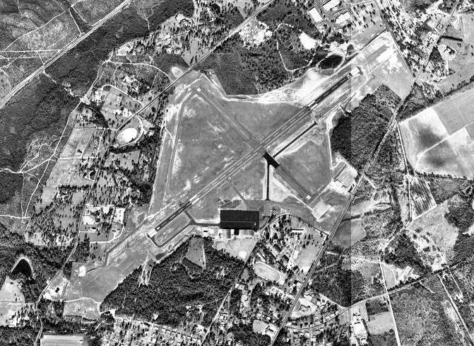
| USGS aerial photo - 4 February 1994 |
| IATA: CDN – ICAO: KCDN – FAA LID: CDN |
| Summary |
| Airport type |
Public |
| Owner |
Kershaw County |
| Serves |
Camden, South Carolina |
| Location |
Kershaw County, near Camden, South Carolina |
| Elevation AMSL |
302 ft / 92 m |
| Coordinates |
34°17′01″N 080°33′54″W / 34.28361°N 80.565°W / 34.28361; -80.565 |
| Runways |
| Direction |
Length |
Surface |
| ft |
m |
| 6/24 |
5,000 |
1,524 |
Asphalt |
| 14/32 |
2,998 |
914 |
Asphalt |
| Statistics (2008) |
| Aircraft operations |
36,400 |
| Based aircraft |
37 |
| Source: Federal Aviation Administration |
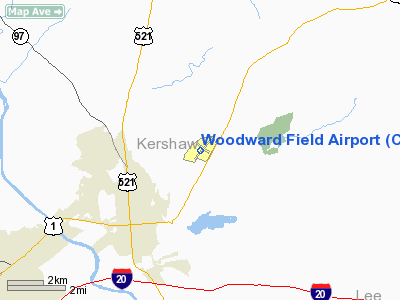
Woodward Field (IATA: CDN, ICAO: KCDN, FAA LID: CDN) is a county-owned public-use airport located three nautical miles (6 km) northeast of the central business district of Camden, a city in Kershaw County, South Carolina, United States. It is also known as the Kershaw County Airport. The airport serves the general aviation community, with no scheduled commercial airline service. History
Woodward Field is named for philanthropist and equestrian Ernest Woodward, who donated 160 acres of land for an airport in 1929. The airport was opened in November 1937.
In 1941 the United States Army Air Forces indicated a need for the airfield as a training airfield. Activated on 22 March 1941, Woodward Field was used by the Army Air Forces Flying Training Command, Southeast Training Center (later Eastern Flying Training Command) as a basic flying training airfield, with instruction being carried out by the 64th Flying Training Detachment. The Camden-based Southern Aviation School was the civilian contractor performing the basic flight training. Flying training was performed with Fairchild PT-19s as the primary trainer. Also had several PT-17 Stearmans and a few P-40 Warhawks assigned.
Robert K. Morgan, pilot of the Memphis Belle B-17 aircraft, had his primary training at Woodward Field. Along with the USAAF flying cadets, Royal Air Force personnel were also trained at Woodward. Two small turf airfields were also used by the training school during the war.
Flying training ended on 4 August 1944 and afterwords the airfield returned to civil control
Facilities and aircraft
Woodward Field covers an area of 396 acres (160 ha) at an elevation of 302 feet (92 m) above mean sea level. It has two asphalt paved runways: 6/24 is a 5,000-by-100-foot (1,500 by 30 m) lighted runway and 14/32 is 2,998 by 100 ft (914 by 30 m) crosswind runway.
For the 12-month period ending March 14, 2008, the airport had 36,400 aircraft operations, an average of 99 per day: 98% general aviation, 1% air taxi and 1% military. At that time there were 37 aircraft based at this airport: 86% single-engine, 5% multi-engine, 3% jet and 5% ultralight.
The airport has two aviation related businesses: Camden Jet Center, a full-service FBO, and Aircraft Maintenance Services.
The above content comes from Wikipedia and is published under free licenses – click here to read more.
Location & QuickFacts
| FAA Information Effective: | 2008-09-25 |
| Airport Identifier: | CDN |
| Airport Status: | Operational |
| Longitude/Latitude: | 080-33-53.5000W/34-17-00.9000N
-80.564861/34.283583 (Estimated) |
| Elevation: | 302 ft / 92.05 m (Surveyed) |
| Land: | 396 acres |
| From nearest city: | 3 nautical miles NE of Camden, SC |
| Location: | Kershaw County, SC |
| Magnetic Variation: | 05W (1985) |
Owner & Manager
| Ownership: | Publicly owned |
| Owner: | Kershaw County |
| Address: | Courthouse, Room 202
Camden, SC 29020 |
| Phone number: | 803-425-1500 |
| Manager: | Mr. John Hindman |
| Address: | 2203 Airline Drive
Camden, SC 29020 |
| Phone number: | 803-425-5285 |
Airport Operations and Facilities
| Airport Use: | Open to public |
| Wind indicator: | Yes |
| Segmented Circle: | Yes |
| Control Tower: | No |
| Lighting Schedule: | DUSK-DAWN
MIRL RY 06/24 PRESET LOW INTST; TO INCR INTST AND ACTVT REIL RYS 06 & 24 - CTAF. |
| Beacon Color: | Clear-Green (lighted land airport) |
| Landing fee charge: | No |
| Sectional chart: | Charlotte |
| Region: | ASO - Southern |
| Boundary ARTCC: | ZJX - Jacksonville |
| Tie-in FSS: | AND - Anderson |
| FSS on Airport: | No |
| FSS Toll Free: | 1-800-WX-BRIEF |
| NOTAMs Facility: | AND (NOTAM-d service avaliable) |
| Federal Agreements: | NGRY3 |
Airport Communications
| CTAF: | 123.000 |
| Unicom: | 123.000 |
Airport Services
| Fuel available: | 100LLA |
| Airframe Repair: | MAJOR |
| Power Plant Repair: | MAJOR |
| Bottled Oxygen: | LOW |
| Bulk Oxygen: | NONE |
Runway Information
Runway 06/24
| Dimension: | 5000 x 100 ft / 1524.0 x 30.5 m |
| Surface: | ASPH, Good Condition
MANY CRACKS IN PAVEMENT WITH GRASS PENETRATION. |
| Weight Limit: | Single wheel: 30000 lbs.
Dual wheel: 55000 lbs.
Dual tandem wheel: 90000 lbs. |
| Edge Lights: | Medium |
| |
Runway 06 |
Runway 24 |
| Longitude: | 080-34-16.9709W | 080-33-30.1892W |
| Latitude: | 34-16-45.0831N | 34-17-15.7177N |
| Elevation: | 286.00 ft | 296.00 ft |
| Alignment: | 52 | 127 |
| Traffic Pattern: | Left | Left |
| Markings: | Non-precision instrument, Good Condition | Non-precision instrument, Good Condition |
| Crossing Height: | 31.00 ft | 28.00 ft |
| VASI: | 2-light PAPI on left side | 2-light PAPI on left side |
| Visual Glide Angle: | 3.00° | 3.00° |
| Runway End Identifier: | Yes | Yes |
| Obstruction: | 28 ft tree, 1127.0 ft from runway, 329 ft left of centerline, 33:1 slope to clear | 78 ft tree, 978.0 ft from runway, 357 ft left of centerline, 9:1 slope to clear |
|
Runway 14/32
| Dimension: | 2998 x 100 ft / 913.8 x 30.5 m |
| Surface: | ASPH, Fair Condition
MANY CRACKS IN PAVEMENT WITH GRASS PENETRATION. |
| Weight Limit: | Single wheel: 30000 lbs.
Dual wheel: 55000 lbs.
Dual tandem wheel: 90000 lbs. |
| |
Runway 14 |
Runway 32 |
| Longitude: | 080-34-06.0019W | 080-33-40.6204W |
| Latitude: | 34-17-12.2631N | 34-16-51.3875N |
| Elevation: | 298.00 ft | 300.00 ft |
| Alignment: | 127 | 127 |
| Traffic Pattern: | Left | Left |
| Markings: | Basic, Good Condition | Basic, Good Condition |
| Obstruction: | 24 ft tree, 573.0 ft from runway, 56 ft left of centerline, 15:1 slope to clear | 57 ft tree, 1164.0 ft from runway, 157 ft left of centerline, 17:1 slope to clear |
|
Radio Navigation Aids
| ID |
Type |
Name |
Ch |
Freq |
Var |
Dist |
| CDN | NDB | Camden | | 263.00 | 05W | 0.2 nm |
| SMS | NDB | Sumter | | 252.00 | 04W | 20.3 nm |
| HVS | NDB | Hartsville | | 341.00 | 07W | 23.3 nm |
| MMT | NDB | Mc Entire | | 427.00 | 05W | 23.9 nm |
| FDW | NDB | Winnsboro | | 414.00 | 05W | 27.3 nm |
| PYG | NDB | Pageland | | 270.00 | 06W | 29.9 nm |
| LKR | NDB | Lancaster | | 400.00 | 07W | 30.2 nm |
| UDG | NDB | Darlington | | 245.00 | 06W | 35.0 nm |
| TWL | NDB | Wesley | | 204.00 | 06W | 40.8 nm |
| DCM | NDB | Chester | | 220.00 | 06W | 43.7 nm |
| CQW | NDB | Cheraw | | 409.00 | 05W | 44.3 nm |
| UZ | NDB | Rally | | 227.00 | 05W | 44.5 nm |
| MNI | NDB | Manning | | 381.00 | 06W | 45.5 nm |
| BES | NDB | Bennettsville | | 230.00 | 07W | 45.9 nm |
| CFY | NDB | Evans | | 420.00 | 06W | 47.4 nm |
| CKI | NDB | Kingstree | | 404.00 | 06W | 49.1 nm |
| SSC | TACAN | Shaw | 038X | | 05W | 19.0 nm |
| CTF | VOR/DME | Chesterfield | 019X | 108.20 | 03W | 26.3 nm |
| MMT | VORTAC | Mc Entire | 079X | 113.20 | 05W | 24.6 nm |
| CAE | VORTAC | Columbia | 094X | 114.70 | 02W | 35.3 nm |
| FLO | VORTAC | Florence | 099X | 115.20 | 03W | 45.2 nm |
| FML | VORTAC | Fort Mill | 071X | 112.40 | 02W | 46.6 nm |
| VAN | VORTAC | Vance | 041X | 110.40 | 06W | 49.0 nm |
Remarks
- AEROBATIC BOX OVERHEAD ARPT UP TO 4000 FT DURG DALGT HRS.
- EXISTED PRIOR TO 1958
Images and information placed above are from
http://www.airport-data.com/airport/CDN/
We thank them for the data!
| General Info
|
| Country |
United States
|
| State |
SOUTH CAROLINA
|
| FAA ID |
CDN
|
| Latitude |
34-17-00.900N
|
| Longitude |
080-33-53.500W
|
| Elevation |
302 feet
|
| Near City |
CAMDEN
|
We don't guarantee the information is fresh and accurate. The data may
be wrong or outdated.
For more up-to-date information please refer to other sources.
|
|