|
|
| North Auxiliary Airfield |
 |
| IATA: none – ICAO: KXNO – FAA LID: XNO |
| Summary |
| Airport type |
Military |
| Owner |
U.S. Air Force |
| Location |
North, South Carolina |
| Elevation AMSL |
321 ft / 98 m |
| Website |
public.charleston.amc.af.mil/... |
| Runways |
| Direction |
Length |
Surface |
| ft |
m |
| 6/24 |
10,000 |
3,048 |
Asphalt |
| 5/23 |
3,500 |
1,067 |
Asphalt |
| Sources: U.S. Air Force and FAA |
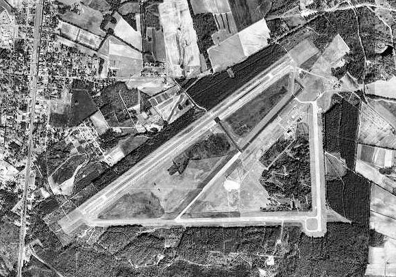
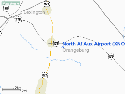
Coordinates: 33°37′01″N 081°04′59″W / 33.61694°N 81.08306°W / 33.61694; -81.08306 North Air Force Auxiliary Airfield (ICAO: KXNO, FAA LID: XNO) is a military airfield located 3 miles (4.8 km) east of North, a town in Orangeburg County, South Carolina, United States.
It is owned by the U.S. Air Force and is used primarily for C-17 Globemaster III training by the 437th Airlift Wing and its Air Force Reserve "Associate" unit, the 315th Airlift Wing, at Charleston Air Force Base. Additional "bare base" operations are also conducted by the 20th Fighter Wing at Shaw Air Force Base and the 169th Fighter Wing at McEntire Air National Guard Station. Other units can utilize North with prior coordination with the 437 AW. The 437th Civil Engineering Squadron (437 CES) of the 437th Airlift Wing at Charleston AFB mainains a detachment to maintain and operate the airfield. The only permanently assigned personnel are 10 USAF firefighters and one civilian grounds keeper. Facilities
North Auxiliary Airfield covers an area of 2,400 acres (971 ha), of which 1,150 acres (465 ha) are undeveloped. It contains two asphalt paved runways: the main runway (6/24) measuring 10,000 x 150 ft (3,048 x 46 m) and an assault runway (5/23) measuring 3,500 x 90 ft (1,067 x 27 m). The primary airstrip runs parallel to U.S. Route 178 but is screened from view from the road by trees.
History
The land for North Army Airfield was bought between 1942 and 1945. The airfield was built by the United States Army Air Forces The original dirt runway was constructed in April 1943 and used by Hughes Aircraft Company for testing, as well as being a satellite airfield of Columbia Army Air Base, supporting B-25 Mitchell medium bomber training for Third Air Force III Air Support Command. Training was accomplished by 74th Station Compliment Squadron which also maintained the facility.
After the war, a 12,000 ft runway and a 3,000 ft assault runway were built. North Airfield (Later North Auxiliary Airfield, Northfield Air Base), has been under the jurisdiction of Fort Jackson, Shaw AFB, the Department of Energy, and on 1 October 1979, Charleston AFB assumed real property jurisdiction, control, and accountability over North Field.
The above content comes from Wikipedia and is published under free licenses – click here to read more.
Location & QuickFacts
| FAA Information Effective: | 2008-09-25 |
| Airport Identifier: | XNO |
| Airport Status: | Operational |
| Longitude/Latitude: | 081-04-52.3857W/33-36-34.0509N
-81.081218/33.609459 (Estimated) |
| Elevation: | 321 ft / 97.84 m (Estimated) |
| Land: | 0 acres |
| From nearest city: | 0 nautical miles of North, SC |
| Location: | Orangeburg County, SC |
| Magnetic Variation: | 05W (1985) |
Owner & Manager
| Ownership: | Air Force owned |
| Owner: | Usaf |
| Address: | Shaw Afb
Sumter, SC 29152 |
| Manager: | Comdr |
| Address: | North Af Aux
North, SC 29112 |
Airport Operations and Facilities
| Airport Use: | Private |
| Wind indicator: | No |
| Segmented Circle: | No |
| Control Tower: | No |
| Beacon Color: | Clear-Green (lighted land airport) |
| Sectional chart: | Charlotte |
| Region: | ASO - Southern |
| Boundary ARTCC: | ZJX - Jacksonville |
| Tie-in FSS: | AND - Anderson
FSS-ANDERSON AND |
| FSS on Airport: | No |
| FSS Toll Free: | 1-800-WX-BRIEF |
Airport Communications
Airport Services
| Airframe Repair: | NONE |
| Power Plant Repair: | NONE |
| Bottled Oxygen: | NONE |
| Bulk Oxygen: | NONE |
Runway Information
Runway 05/23
| Dimension: | 3500 x 90 ft / 1066.8 x 27.4 m |
| Surface: | ASPH, |
| Pavement Class: | 97 /F/A/W/T |
| |
Runway 05 |
Runway 23 |
| Longitude: | 081-04-39.3600W | 081-04-10.3300W |
| Latitude: | 33-36-26.3900N | 33-36-51.0600N |
| Elevation: | 292.00 ft | 320.00 ft |
| Traffic Pattern: | Left | Left |
|
Runway 06/24
| Dimension: | 10000 x 150 ft / 3048.0 x 45.7 m |
| Surface: | ASPH, |
| Pavement Class: | 60 /F/A/W/T |
| Edge Lights: | High |
| |
Runway 06 |
Runway 24 |
| Longitude: | 081-05-49.6500W | 081-04-14.4000W |
| Latitude: | 33-36-03.1300N | 33-37-01.7000N |
| Elevation: | 225.00 ft | 287.00 ft |
| Traffic Pattern: | Left | Left |
| Displaced threshold: | 1000.00 ft | 1000.00 ft |
|
Radio Navigation Aids
| ID |
Type |
Name |
Ch |
Freq |
Var |
Dist |
| OYI | NDB | Orangeburg | | 226.00 | 05W | 14.5 nm |
| BKO | NDB | Barnwell | | 392.00 | 06W | 23.3 nm |
| MMT | NDB | Mc Entire | | 427.00 | 05W | 24.2 nm |
| AIK | NDB | Aiken | | 347.00 | 04W | 29.9 nm |
| FDW | NDB | Winnsboro | | 414.00 | 05W | 42.4 nm |
| SMS | NDB | Sumter | | 252.00 | 04W | 42.7 nm |
| MNI | NDB | Manning | | 381.00 | 06W | 43.8 nm |
| RBW | NDB | Walterboro | | 221.00 | 05W | 46.7 nm |
| EMR | NDB | Emory | | 385.00 | 04W | 46.7 nm |
| CDN | NDB | Camden | | 263.00 | 05W | 48.1 nm |
| SSC | TACAN | Shaw | 038X | | 05W | 37.9 nm |
| ALD | VOR | Allendale | | 116.70 | 01W | 37.4 nm |
| EDS | VOR/DME | Edisto | 051X | 111.40 | 05W | 14.5 nm |
| CAE | VORTAC | Columbia | 094X | 114.70 | 02W | 15.0 nm |
| MMT | VORTAC | Mc Entire | 079X | 113.20 | 05W | 23.5 nm |
| VAN | VORTAC | Vance | 041X | 110.40 | 06W | 32.7 nm |
Remarks
- RSTD: OPR RSTD DUR BIRD WATCH COND MODERATE(TKOF OR LDG PERMS ONLY WHEN DEP/ARR RTE AVOID IDENT BIRD ACT, NO LCL IFR/VFR TFC PAT ACT) AND SEVERE (TKOF AND LDG PROH WO OG/CC APVL), CTC TWR FOR CURRENT BIRD WATCH COND. MIN 2 WK PRIOR COORD RQR FOR ALL USERS.
- NS ABTMT: OVFT OF NORTH, SC PROH.
- RSTD: TXY DELTA CLSD DURING BOX-IN-ONE OPS TO RWY 23.
- RSTD: RUNWAY 6 & 24 TAKEOFF DISTANCE AVAILABLE 9000 FT, LANDING DISTANCE AVAILABLE 8000 FT.
- SEE FLIP AP/1 SUPPLEMENTARY ARPT RMK.
- CAUTION: INTS HVY MIL JET AND MISC ACFT EXECUTING NUMEROUS CARGO AND PERS DROPS, HI-SPEED LO-LEVEL FORMATION FLT, AND AIRLAND OPR. RWY 6-24 NW TREE LINE 750' FR RWY CNTRLINE.
- CAUTION: RWY 6-24 LARGE DITCH 350' FR RWY CNTRLINE AT MIDFIELD ON NW SIDE RWY. INTS GND TRNG ON RESERVATION. RWY 5-23 USED AS LDG ZONE 3500' X 90'.
- RSTD: POC IS CHARLESTON AFB, 437 OSS/OSO, DSN 673-5554, C843-963-5554. ALL AIRCREWS WILL CTC NORTH DZ ON 118.15 235.775 PRIOR TO 5NM TO DZ. THIS AIRSPACE IS SUBJ TO BE RSTD BY NOTAM. RWY 06-24, NO 180‘ STAR TURNS ON ASPHALT, CONDUCT ALL TURNS ON CONCRETE ENDS.
- RSTD: RWY 05/23 CLSD 1300-1500Z++ MONTHLY 3RD THU. RWY 06/24 CLSD 1601-2100Z++ MONTHLY 3RD THU.
- MISC: RWY 05-23 AND 6-24 GROOVED. TWR LTD TO ADVSY SVC ONLY. VFR ONLY. CNL IFR CLNC WITH COLUMBIA APP PRIOR TO OPR AT NORTH AF AUX.
Images and information placed above are from
http://www.airport-data.com/airport/XNO/
We thank them for the data!
| General Info
|
| Country |
United States
|
| State |
SOUTH CAROLINA
|
| FAA ID |
XNO
|
| Latitude |
33-37-00.550N
|
| Longitude |
081-04-59.346W
|
| Elevation |
290 feet
|
| Near City |
NORTH
|
We don't guarantee the information is fresh and accurate. The data may
be wrong or outdated.
For more up-to-date information please refer to other sources.
|
|