 |
|
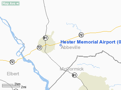
Location & QuickFacts
| FAA Information Effective: | 2008-09-25 |
| Airport Identifier: | 0A2 |
| Airport Status: | Operational |
| Longitude/Latitude: | 082-34-04.4720W/34-05-25.4160N
-82.567909/34.090393 (Estimated) |
| Elevation: | 517 ft / 157.58 m (Estimated) |
| Land: | 18 acres |
| From nearest city: | 1 nautical miles E of Calhoun Falls, SC |
| Location: | Abbeville County, SC |
| Magnetic Variation: | 04W (1985) |
Owner & Manager
| Ownership: | Publicly owned |
| Owner: | City Of Calhoun Falls |
| Address: | Po Box 246
Calhoun Falls, SC 29628 |
| Phone number: | 864-447-8512 |
| Manager: | Forrest Lacons |
| Address: | Po Box 246
Calhoun Falls, SC 29628 |
| Phone number: | 864-378-1149 |
Airport Operations and Facilities
| Airport Use: | Open to public |
| Segmented Circle: | No |
| Control Tower: | No |
| Lighting Schedule: | DUSK-DAWN |
| Landing fee charge: | No |
| Sectional chart: | Atlanta |
| Region: | ASO - Southern |
| Boundary ARTCC: | ZTL - Atlanta |
| Tie-in FSS: | AND - Anderson |
| FSS on Airport: | No |
| FSS Toll Free: | 1-800-WX-BRIEF |
| NOTAMs Facility: | AND (NOTAM-d service avaliable) |
Airport Communications
Airport Services
| Airframe Repair: | NONE |
| Power Plant Repair: | NONE |
| Bottled Oxygen: | NONE |
| Bulk Oxygen: | NONE |
Runway Information
Runway 10/28
| Dimension: | 3917 x 60 ft / 1193.9 x 18.3 m |
| Surface: | ASPH, Poor Condition
RY 10/28 & APRON CRACKING BADLY. GRASS COMING UP THRU CRACKS. |
| Weight Limit: | Single wheel: 12500 lbs. |
| Edge Lights: | Low |
| |
Runway 10 |
Runway 28 |
| Traffic Pattern: | Left | Left |
| Markings: | Basic, Poor Condition
RY 10 MARKINGS FADED. | Basic, Poor Condition
RY 28 MARKINGS FADED. |
| Runway End Identifier: | No | No |
| Centerline Lights: | No | No |
| Touchdown Lights: | No | No |
| Obstruction: | 39 ft tree, 866.0 ft from runway, 11 ft right of centerline, 17:1 slope to clear | 31 ft tree, 668.0 ft from runway, 168 ft right of centerline, 15:1 slope to clear
4 FT FENCE WITHIN THE PRIMARY SFC. |
|
Radio Navigation Aids
| ID |
Type |
Name |
Ch |
Freq |
Var |
Dist |
| IIY | NDB | Washington/wilkes County | | 435.00 | 03W | 22.6 nm |
| AND | NDB | Anderson County | | 230.00 | 04W | 25.5 nm |
| GIW | NDB | Coronaca | | 239.00 | 04W | 25.9 nm |
| BJT | NDB | Bulldog | | 221.00 | 03W | 33.5 nm |
| AA | NDB | Cedar | | 341.00 | 04W | 33.6 nm |
| HQU | NDB | Thomson-mcduffie | | 333.00 | 04W | 33.9 nm |
| VV | NDB | Junne | | 353.00 | 05W | 35.0 nm |
| GY | NDB | Dyana | | 338.00 | 03W | 36.6 nm |
| CEU | NDB | Clemson | | 257.00 | 05W | 38.5 nm |
| LUX | NDB | Laurens | | 307.00 | 04W | 39.7 nm |
| LQK | NDB | Lake Keowee | | 408.00 | 04W | 43.8 nm |
| EMR | NDB | Emory | | 385.00 | 04W | 47.3 nm |
| DDA | NDB | Commerce | | 244.00 | 03W | 47.5 nm |
| EOE | NDB | Enoree | | 278.00 | 05W | 48.2 nm |
| ELW | VORTAC | Electric City | 023X | 108.60 | 00E | 22.5 nm |
| GRD | VORTAC | Greenwood | 102X | 115.50 | 01W | 22.7 nm |
| IRQ | VORTAC | Colliers | 086X | 113.90 | 04W | 30.7 nm |
| AHN | VORTAC | Athens | 33 | 109.60 | 00E | 38.7 nm |
Remarks
- REMOTE CONTROLLED ACFT INVOF ARPT.
- EXISTED PRIOR TO 1958.
Images and information placed above are from
http://www.airport-data.com/airport/0A2/
We thank them for the data!
| General Info
|
| Country |
United States
|
| State |
SOUTH CAROLINA
|
| FAA ID |
0A2
|
| Latitude |
34-05-25.416N
|
| Longitude |
082-34-04.472W
|
| Elevation |
517 feet
|
| Near City |
CALHOUN FALLS
|
We don't guarantee the information is fresh and accurate. The data may
be wrong or outdated.
For more up-to-date information please refer to other sources.
|
|


