|
|
Greenville Downtown Airport |
| Greenville Downtown Airport |
 |
| IATA: GMU – ICAO: KGMU – FAA LID: GMU |
| Summary |
| Airport type |
Public |
| Owner |
Greenville Airport Commission |
| Serves |
Greenville, South Carolina |
| Elevation AMSL |
1,048 ft / 319 m |
| Coordinates |
34°50′53″N 082°21′00″W / 34.84806°N 82.35°W / 34.84806; -82.35 |
| Runways |
| Direction |
Length |
Surface |
| ft |
m |
| 1/19 |
5,393 |
1,644 |
Asphalt |
| 10/28 |
3,998 |
1,219 |
Asphalt |
| Helipads |
| Number |
Length |
Surface |
| ft |
m |
| H1 |
50 |
15 |
Concrete |
| H2 |
50 |
15 |
Concrete |
| Statistics (2007) |
| Aircraft operations |
76,260 |
| Based aircraft |
250 |
| Source: Federal Aviation Administration |
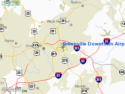
Greenville Downtown Airport (IATA: GMU, ICAO: KGMU, FAA LID: GMU) is a public airport located three miles (5 km) east of the central business district of Greenville, a city in Greenville County, South Carolina, United States. It is owned by the Greenville Airport Commission. Governance, Facilities and aircraft
The Downtown Airport property is tax exempt public property.It is governed by a 5-person appointed Commission authorized by Act 844. Two appointees each from City and County Councils and one at-large serve three year terms. Commissioners have the power to establish and maintain parks and sell any or all of the public property it governs as provided by law. The airport is exempt from complying with local noise ordinances and may receive gifts or donations from any source. http://www.greenvillecounty.org/County_Council/boards_commissions/airport_commission...
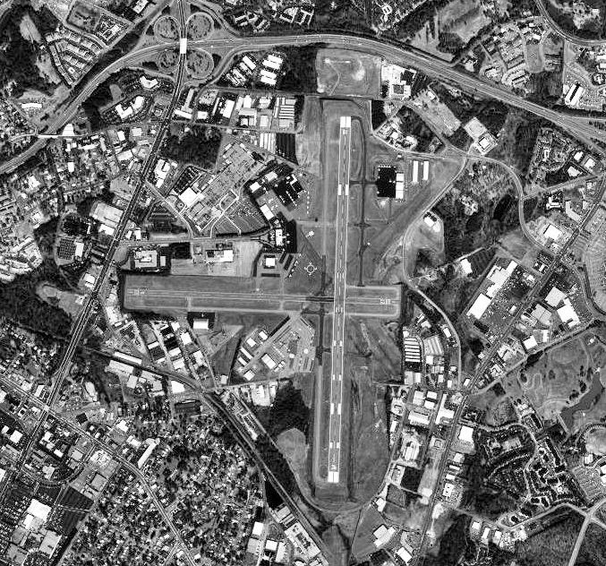
Greenville Downtown Airport covers an area of 385 acres (156 ha) which contains two asphalt paved runways: 1/19 measuring 5,393 x 100 ft (1,644 x 30 m) and 10/28 measuring 3,998 x 80 ft (1,219 x 24 m). It also had two helipads, each with a 50 x 50 ft (15 x 15 m) concrete surface.
For the 12-month period ending August 28, 2007, the airport had 76,260 aircraft operations, an average of 208 per day: 63% general aviation, 33% air taxi and 4% military. At that time there were 250 aircraft based at this airport: 67% single-engine, 24% multi-engine, 6% jet and 2% helicopter. In July 2008 DayJet announced nonstop per seat VLJ service on twin pilot, twin jet planes to 14 hubs in 3 states bolstering the Air Taxi component of the airport's flights.
History
Greenville Municipal Airport was opened as a commercial airport in September, 1937. During World War II, the United States Army Air Force indicated a need for the airfield as a training airfield. The airport was used jointly by the Army Air Forces Flying Training Command, Southeast Training Center (later Eastern Flying Training Command) as a contract glider training school, operated by Southern Airways, Inc from 1941 until mid-1943.
The airport was then reassigned to Air Technical Service Command, and used as a supply and maintenance depot until being returned to full civil control in October 1945.
In October 1959, Brooklyn Dodgers baseball star Jackie Robinson was arrested at the airport for refusing to leave the whites only waiting room. On February 20, 1961, after marches by the NAACP and a visitation by Dr. Martin Luther King, the Downtown Airport Commission was forced to desegregate by Federal Court order. (greenvilleonline.com/.../Greenville-airport-protest-started-an-avalanche)
Commercial operations were moved shortly thereafter in October 1962 to the Greenville/Spartanburg Jetport (GSP) to accommodate jet traffic away from densely populated areas.
Since then the downtown airport has been a subject of best land use controversy, public concern about low flying small plane activity (under 1000 feet) over heavily populated areas and flight path interference with GSP commercial operations.
It was from this airport that the fatal flight of the Lynyrd Skynyrd Convair 240 departed on October 20, 1977.
The above content comes from Wikipedia and is published under free licenses – click here to read more.
Location & QuickFacts
| FAA Information Effective: | 2008-09-25 |
| Airport Identifier: | GMU |
| Airport Status: | Operational |
| Longitude/Latitude: | 082-21-00.0000W/34-50-52.6000N
-82.350000/34.847944 (Estimated) |
| Elevation: | 1048 ft / 319.43 m (Surveyed) |
| Land: | 385 acres |
| From nearest city: | 3 nautical miles E of Greenville, SC |
| Location: | Greenville County, SC |
| Magnetic Variation: | 05W (1985) |
Owner & Manager
| Ownership: | Publicly owned |
| Owner: | Greenville Airport Commission |
| Address: | 100 Tower Dr, Unit 2
Greenville, SC 29607 |
| Phone number: | 864-242-4777 |
| Manager: | Joe Frasher |
| Address: | 100 Tower Dr, Unit 2
Greenville, SC 29607 |
| Phone number: | 864-242-4777 |
Airport Operations and Facilities
| Airport Use: | Open to public |
| Wind indicator: | Yes |
| Segmented Circle: | Yes |
| Control Tower: | Yes |
| Lighting Schedule: | DUSK-DAWN
WHEN ATCT CLSD ACTVT HIRL RY 01/19, REIL RYS 01 & 19 AND PERIMETER LGTS H1 & H2 - CTAF. |
| Beacon Color: | Clear-Green (lighted land airport) |
| Landing fee charge: | No |
| Sectional chart: | Atlanta |
| Region: | ASO - Southern |
| Boundary ARTCC: | ZTL - Atlanta |
| Tie-in FSS: | AND - Anderson |
| FSS on Airport: | No |
| FSS Toll Free: | 1-800-WX-BRIEF |
| NOTAMs Facility: | GMU (NOTAM-d service avaliable) |
| Federal Agreements: | NGY3 |
Airport Communications
| CTAF: | 119.900 |
| Unicom: | 122.950 |
Airport Services
| Fuel available: | 100LLA |
| Airframe Repair: | MAJOR |
| Power Plant Repair: | MAJOR |
| Bottled Oxygen: | HIGH/LOW |
| Bulk Oxygen: | NONE |
Runway Information
Runway 01/19
| Dimension: | 5393 x 100 ft / 1643.8 x 30.5 m |
| Surface: | ASPH, Good Condition |
| Surface Treatment: | Saw-cut or plastic Grooved |
| Weight Limit: | Single wheel: 44000 lbs.
Dual wheel: 60000 lbs.
Dual tandem wheel: 95000 lbs. |
| Edge Lights: | High |
| |
Runway 01 |
Runway 19 |
| Longitude: | 082-20-54.9176W | 082-20-53.5640W |
| Latitude: | 34-50-25.8077N | 34-51-19.1340N |
| Elevation: | 988.00 ft | 1048.00 ft |
| Alignment: | 1 | 127 |
| ILS Type: | ILS
| |
| Traffic Pattern: | Left | Right |
| Markings: | Precision instrument, Good Condition | Precision instrument, Good Condition |
| Crossing Height: | 35.00 ft | 30.00 ft |
| VASI: | 4-light PAPI on left side | 4-light PAPI on left side |
| Approach lights: | MALSF | |
| Runway End Identifier: | Yes | Yes |
| Obstruction: | 10 ft tree, 250.0 ft from runway, 92 ft left of centerline, 4:1 slope to clear | 100 ft tree, 2158.0 ft from runway, 312 ft left of centerline, 19:1 slope to clear |
|
Runway 10/28
| Dimension: | 3998 x 80 ft / 1218.6 x 24.4 m |
| Surface: | ASPH, Good Condition |
| Weight Limit: | Single wheel: 20000 lbs. |
| Edge Lights: | Medium |
| |
Runway 10 |
Runway 28 |
| Longitude: | 082-21-31.7220W | 082-20-43.7730W |
| Latitude: | 34-50-53.1150N | 34-50-52.1890N |
| Elevation: | 994.00 ft | 1014.00 ft |
| Alignment: | 91 | 127 |
| Traffic Pattern: | Left | Right |
| Markings: | Basic, Good Condition
MARKINGS FADED. | Basic, Good Condition
MARKINGS FADED. |
| Crossing Height: | 0.00 ft | 40.00 ft |
| Displaced threshold: | 265.00 ft | 270.00 ft |
| VASI: | | 2-light PAPI on left side |
| Visual Glide Angle: | 0.00° | 3.00° |
| Runway End Identifier: | No | Yes |
| Obstruction: | 56 ft tree, 1002.0 ft from runway, 226 ft left of centerline, 14:1 slope to clear
RY 10 APCH IS 20:1 AT DSPLCD THLD. | 20 ft tree, 327.0 ft from runway, 92 ft left of centerline, 6:1 slope to clear
RY 28 APCH IS 20:1 AT DSPLCD THLD. |
| Decleard distances: | Take off run available 3998.00 ft
Take off distance available 3998.00 ft
Actual stop distance available 3728.00 ft
Landing distance available 3463.00 ft
| Take off run available 3998.00 ft
Take off distance available 3998.00 ft
Actual stop distance available 3733.00 ft
Landing distance available 3463.00 ft
|
|
Helipad H1
| Dimension: | 50 x 50 ft / 15.2 x 15.2 m |
| Surface: | CONC, Good Condition |
| Weight Limit: | Single wheel: 20000 lbs. |
| |
Runway H1 |
Runway |
| Traffic Pattern: | Left | Left |
|
Helipad H2
| Dimension: | 50 x 50 ft / 15.2 x 15.2 m |
| Surface: | CONC, Good Condition |
| Weight Limit: | Single wheel: 20000 lbs. |
| |
Runway H2 |
Runway |
| Traffic Pattern: | Left | Left |
|
Radio Navigation Aids
| ID |
Type |
Name |
Ch |
Freq |
Var |
Dist |
| GY | NDB | Dyana | | 338.00 | 03W | 10.5 nm |
| LQK | NDB | Lake Keowee | | 408.00 | 04W | 17.6 nm |
| FRT | NDB | Fairmont | | 248.00 | 05W | 18.3 nm |
| BRA | NDB | Broad River | | 379.00 | 04W | 26.2 nm |
| AND | NDB | Anderson County | | 230.00 | 04W | 27.5 nm |
| LUX | NDB | Laurens | | 307.00 | 04W | 28.4 nm |
| CEU | NDB | Clemson | | 257.00 | 05W | 28.5 nm |
| RFE | NDB | Rutherford | | 344.00 | 05W | 35.9 nm |
| UOT | NDB | Union County | | 326.00 | 04W | 36.3 nm |
| GIW | NDB | Coronaca | | 239.00 | 04W | 38.0 nm |
| SLP | NDB | First River | | 417.00 | 06W | 44.3 nm |
| EOE | NDB | Enoree | | 278.00 | 05W | 47.8 nm |
| SPA | VORTAC | Spartanburg | 104X | 115.70 | 02W | 23.6 nm |
| ELW | VORTAC | Electric City | 023X | 108.60 | 00E | 33.6 nm |
| SUG | VORTAC | Sugarloaf Mountain | 059X | 112.20 | 02W | 33.8 nm |
| GRD | VORTAC | Greenwood | 102X | 115.50 | 01W | 37.1 nm |
| ODF | VORTAC | Foothills | 081X | 113.40 | 00E | 47.7 nm |
Remarks
- ACFT OPER IN THE GREENVILLE ARPT TFC AREA S THRU E BE ALERT FOR JET & CONVENTIONAL TFC DES ON THE GREENVILLE-SPARTANBURG LOC COURSE.
- ACFT INBD FROM THE SSW OR ON ILS RY 01 APCH BE ALERT FOR TFC 4.5 MI S OPERG IN THE DONALDSON CENTER ARPT TFC PAT AT 1800 FT OR BLO.
- NO OVERNIGHT PARKING ON HELIPADS.
- NO ACFT PERMITTED ON TWYS 'C' OR 'D' WHEN ACFT GREATER THAN 12,500 LBS IS OPERATING ON RY 10/28.
- RY 10/28 RESTRICTED TO ACFT LESS THAN 12,500 LBS WHEN ACFT GREATER THAN 12,500 LBS IS OPERATING ON TWYS 'C' OR 'D'.
- ENGINEERED MATERIAL ARRESTING SYSTEM (EMAS) 157 FT IN LENGTH BY 113 FT IN WIDTH AT THE DEPARTURE END OF RY 01.
- ARPT EXISTED PRIOR TO 1959; HELIPADS ARE CONDITIONAL. SEE AIRSPACE LETTER DATED JAN 24, 1990 FOR CONDITIONS.
Images and information placed above are from
http://www.airport-data.com/airport/GMU/
We thank them for the data!
| General Info
|
| Country |
United States
|
| State |
SOUTH CAROLINA
|
| FAA ID |
GMU
|
| Latitude |
34-50-52.600N
|
| Longitude |
082-21-00.000W
|
| Elevation |
1048 feet
|
| Near City |
GREENVILLE
|
We don't guarantee the information is fresh and accurate. The data may
be wrong or outdated.
For more up-to-date information please refer to other sources.
|
|