 |
|
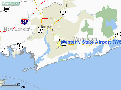
| Westerly State Airport |
 |
| USGS aerial image, 5 April 2001 |
| IATA: WST – ICAO: KWST – FAA LID: WST |
| Summary |
| Airport type |
Public |
| Owner/Operator |
Rhode Island Airport Corp. |
| Serves |
Westerly, Rhode Island |
| Elevation AMSL |
81 ft / 25 m |
| Coordinates |
41°20′59″N 071°48′12″W / 41.34972°N 71.80333°W / 41.34972; -71.80333 |
| Runways |
| Direction |
Length |
Surface |
| ft |
m |
| 7/25 |
4,010 |
1,222 |
Asphalt |
| 14/32 |
3,960 |
1,207 |
Asphalt |
| Statistics (2008) |
| Aircraft operations |
23,288 |
| Based aircraft |
75 |
| Source: Federal Aviation Administration |
Westerly State Airport (IATA: WST, ICAO: KWST, FAA LID: WST) is a public use airport in Washington County, Rhode Island, United States. It serves the city of Westerly and is located two nautical miles (3.7 km) southeast of its central business district.
It is primarily a general aviation airport, but there is also scheduled airline service to Block Island provided by New England Airlines.
Westerly State Airport is one of six active airports operated by the Rhode Island Airport Corporation. The other five airports include T.F. Green State Airport, Newport State Airport, North Central State Airport, Quonset State Airport, and Block Island State Airport. History
Westerly State began as a grass strip in the 1920s, and became the second state-owned airport in the United States (after T.F. Green Airport) in the 1940s. The airport was paved and expanded when it became a U.S. Navy base during World War II, due to its prime location halfway between Boston and New York City.
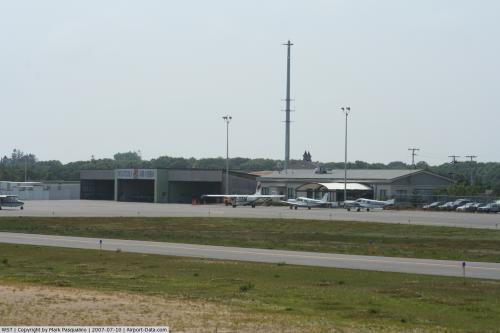
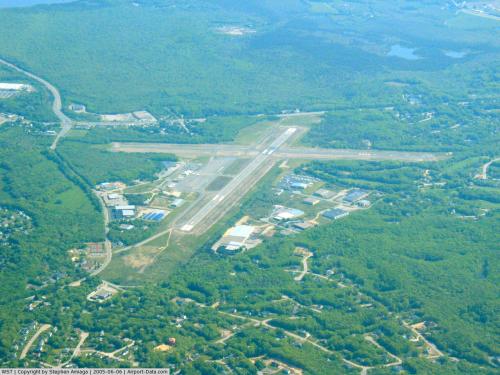
Facilities and aircraft
Westerly State Airport covers an area of 321 acres (130 ha) at an elevation of 81 feet (25 m) above mean sea level. It has two asphalt paved runways: 7/25 is 4,010 by 100 feet (1,222 x 30 m) and 14/32 is 3,960 by 75 feet (1,207 x 23 m).
In 2005, $3.4 million in federal funding was allocated to repair and improve the main runway and taxiways. As of November 2006, improvements were finished and the main runway is open.
For the 12-month period ending June 30, 2008, the airport had 23,288 aircraft operations, an average of 63 per day: 72% general aviation, 28% air taxi and <1% military. At that time there were 75 aircraft based at this airport: 84% single-engine, 13% multi-engine and 3% helicopter.
Airline
- New England Airlines (Block Island)
The above content comes from Wikipedia and is published under free licenses – click here to read more.
 |
(Click on the photo to enlarge) |
 |
(Click on the photo to enlarge) |
Location & QuickFacts
| FAA Information Effective: | 2008-09-25 |
| Airport Identifier: | WST |
| Airport Status: | Operational |
| Longitude/Latitude: | 071-48-12.1600W/41-20-58.6210N
-71.803378/41.349617 (Estimated) |
| Elevation: | 81 ft / 24.69 m (Surveyed) |
| Land: | 321 acres |
| From nearest city: | 2 nautical miles SE of Westerly, RI |
| Location: | Washington County, RI |
| Magnetic Variation: | 15W (1995) |
Owner & Manager
| Ownership: | Publicly owned |
| Owner: | Rhode Island Airports Corp |
| Address: | 2000 Post Rd
Warwick, RI 02886 |
| Phone number: | 401-737-4000 |
| Manager: | Jim Cowley |
| Address: | 210 Airport Rd
North Kingstown, RI 02852 |
| Phone number: | 401-596-2357 |
Airport Operations and Facilities
| Airport Use: | Open to public |
| Wind indicator: | Yes |
| Segmented Circle: | Yes |
| Control Tower: | No |
| Lighting Schedule: | DUSK-DAWN
ACTVT MIRL RYS 07/25 & 14/32; MALSF RY 07 & REIL RYS 25; 14 & 32 & PAPI RYS 14 & 32 - CTAF . |
| Beacon Color: | Clear-Green (lighted land airport) |
| Landing fee charge: | Yes
LANDING FEE FOR COMMERCIAL & NON-RHODE ISLAND REGISTERED ACFT. |
| Sectional chart: | New York |
| Region: | ANE - New England |
| Boundary ARTCC: | ZBW - Boston |
| Tie-in FSS: | BDR - Bridgeport |
| FSS on Airport: | No |
| FSS Toll Free: | 1-800-WX-BRIEF |
| NOTAMs Facility: | WST (NOTAM-d service avaliable) |
| Federal Agreements: | NGY3 |
Airport Communications
| CTAF: | 123.000 |
| Unicom: | 123.000 |
Airport Services
| Fuel available: | 100LLA
SELF SVC 100LL FUEL AVBL 24 HRS. |
| Airframe Repair: | MAJOR |
| Power Plant Repair: | MAJOR |
| Bottled Oxygen: | NONE |
| Bulk Oxygen: | NONE |
Runway Information
Runway 07/25
| Dimension: | 4010 x 100 ft / 1222.2 x 30.5 m |
| Surface: | ASPH, Fair Condition |
| Surface Treatment: | Saw-cut or plastic Grooved |
| Weight Limit: | Single wheel: 30000 lbs.
Dual wheel: 60000 lbs. |
| Edge Lights: | Medium |
| |
Runway 07 |
Runway 25 |
| Longitude: | 071-48-38.1230W | 071-47-56.0210W |
| Latitude: | 41-20-44.1520N | 41-21-07.8750N |
| Elevation: | 51.00 ft | 78.00 ft |
| Alignment: | 53 | 127 |
| ILS Type: | LOC/DME
| |
| Traffic Pattern: | Left | Left |
| Markings: | Non-precision instrument, Good Condition | Non-precision instrument, Good Condition |
| Crossing Height: | 56.00 ft | 26.00 ft |
| VASI: | 4-box on right side | 2-box on left side |
| Visual Glide Angle: | 3.60° | 3.00° |
| Approach lights: | MALSF | |
| Runway End Identifier: | No | Yes |
| Centerline Lights: | No | No |
| Touchdown Lights: | No | No |
| Obstruction: | 67 ft trees, 1600.0 ft from runway, 275 ft right of centerline, 20:1 slope to clear | 40 ft trees, 1000.0 ft from runway, 25 ft left of centerline, 20:1 slope to clear |
|
Runway 14/32
| Dimension: | 3960 x 75 ft / 1207.0 x 22.9 m |
| Surface: | ASPH, Good Condition |
| Weight Limit: | Single wheel: 12500 lbs. |
| Edge Lights: | Medium |
| |
Runway 14 |
Runway 32 |
| Longitude: | 071-48-27.0280W | 071-47-47.3100W |
| Latitude: | 41-21-14.2790N | 41-20-49.0790N |
| Elevation: | 57.00 ft | 81.00 ft |
| Alignment: | 127 | 127 |
| Traffic Pattern: | Left | Left |
| Markings: | Basic, Good Condition | Basic, Good Condition |
| Crossing Height: | 40.00 ft | 40.00 ft |
| Displaced threshold: | 0.00 ft | 750.00 ft |
| VASI: | 4-light PAPI on left side | 4-light PAPI on left side |
| Visual Glide Angle: | 4.00° | 4.00° |
| Runway End Identifier: | Yes | Yes |
| Centerline Lights: | No | No |
| Touchdown Lights: | No | No |
| Obstruction: | 51 ft trees, 900.0 ft from runway, 150 ft left of centerline, 13:1 slope to clear | 36 ft trees, 450.0 ft from runway, 150 ft right of centerline, 6:1 slope to clear
20:1 TO DSPLD THR. |
|
Radio Navigation Aids
| ID |
Type |
Name |
Ch |
Freq |
Var |
Dist |
| SFZ | NDB | Central | | 241.00 | 15W | 37.0 nm |
| HF | NDB | Lomis | | 244.00 | 15W | 40.8 nm |
| MMK | NDB | Meriden | | 238.00 | 14W | 47.2 nm |
| TAN | NDB | Taunton | | 227.00 | 16W | 47.5 nm |
| IHM | NDB | Mansfield | | 220.00 | 16W | 47.8 nm |
| FOK | TACAN | Suffolk Co | 047X | | 13W | 48.5 nm |
| GON | VOR/DME | Groton | 45Y | 110.85 | 14W | 11.3 nm |
| SEY | VOR/DME | Sandy Point | 125X | 117.80 | 15W | 15.0 nm |
| ORW | VOR/DME | Norwich | 037X | 110.00 | 14W | 15.2 nm |
| PUT | VOR/DME | Putnam | 121X | 117.40 | 14W | 36.5 nm |
| HFD | VOR/DME | Hartford | 096X | 114.90 | 13W | 37.8 nm |
| MAD | VOR/DME | Madison | 041X | 110.40 | 13W | 40.2 nm |
| HVN | VOR/DME | New Haven | 035X | 109.80 | 13W | 49.1 nm |
| PVD | VORTAC | Providence | 103X | 115.60 | 14W | 28.1 nm |
| HTO | VORTAC | Hampton | 083X | 113.60 | 13W | 34.8 nm |
| GON | VOT | Groton | | 110.25 | | 11.3 nm |
| PVD | VOT | Providence | | 108.20 | | 28.2 nm |
| HFD | VOT | Hartford | | 108.20 | | 44.6 nm |
Remarks
- DEER & BIRDS ON & INVOF ARPT.
- RY CONDS MAY NOT BE MONITORED OR REPORTED WHEN ARPT IS UNATNDD, CALL AMGR 401-295-5020.
- OVERNIGHT PARKING FEE.
- ARPT LOCATED IN NOISE SENSITIVE AREA & POPULATED AREAS TO THE SOUTH & WEST SHOULD BE AVOIDED.
- BANNER TOW OPERATIONS ON AIRFIELD & BELOW 1000 FT ALONG SOUTHERN COAST OF RHODE ISLAND.
- ARPT EXISTED PRIOR TO 1959.
Images and information placed above are from
http://www.airport-data.com/airport/WST/
We thank them for the data!
| General Info
|
| Country |
United States
|
| State |
RHODE ISLAND
|
| FAA ID |
WST
|
| Latitude |
41-20-58.621N
|
| Longitude |
071-48-12.160W
|
| Elevation |
81 feet
|
| Near City |
WESTERLY
|
We don't guarantee the information is fresh and accurate. The data may
be wrong or outdated.
For more up-to-date information please refer to other sources.
|
|


