 |
|
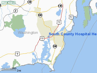
South County Hospital Heliport |
Location & QuickFacts
| FAA Information Effective: | 2008-09-25 |
| Airport Identifier: | RI08 |
| Airport Status: | Operational |
| Longitude/Latitude: | 071-29-45.2070W/41-25-51.3660N
-71.495891/41.430935 (Estimated) |
| Elevation: | 38 ft / 11.58 m (Estimated) |
| Land: | 0 acres |
| From nearest city: | 1 nautical miles S of Wakefield, RI |
| Location: | Washington County, RI |
| Magnetic Variation: | 15W (1985) |
Owner & Manager
| Ownership: | Privately owned |
| Owner: | South County Hospital |
| Address: | 100 Kenyon Avenue
Wakefield, RI 02879 |
| Phone number: | 401-788-1447 |
| Manager: | Barbara Keaney |
| Address: | 100 Kenyon Avenue
Wakefield, RI 02879-4216 |
| Phone number: | 401-788-1447
EXT 1430 EMERG DEPT; 1447 AMGR. |
Airport Operations and Facilities
| Airport Use: | Private
MEDICAL USE. |
| Wind indicator: | Yes |
| Segmented Circle: | No |
| Control Tower: | No |
| Landing fee charge: | No |
| Sectional chart: | New York |
| Region: | ANE - New England |
| Boundary ARTCC: | ZBW - Boston |
| Tie-in FSS: | BDR - Bridgeport |
| FSS on Airport: | No |
| FSS Toll Free: | 1-800-WX-BRIEF |
Airport Services
| Airframe Repair: | NONE |
| Power Plant Repair: | NONE |
Runway Information
Helipad H1
| Dimension: | 100 x 40 ft / 30.5 x 12.2 m |
| Surface: | ASPH, |
| |
Runway H1 |
Runway |
| Traffic Pattern: | Left | Left |
|
Radio Navigation Aids
| ID |
Type |
Name |
Ch |
Freq |
Var |
Dist |
| ORW | FAN MARKER | Canton | | | 15W | 46.4 nm |
| SFZ | NDB | Central | | 241.00 | 15W | 29.3 nm |
| TAN | NDB | Taunton | | 227.00 | 16W | 34.3 nm |
| IHM | NDB | Mansfield | | 220.00 | 16W | 36.9 nm |
| FFF | NDB | Plymouth | | 257.00 | 16W | 40.0 nm |
| FMH | TACAN | Otis | 105X | | 15W | 46.3 nm |
| NZW | TACAN | South Weymouth | 061X | | 15W | 49.9 nm |
| SEY | VOR/DME | Sandy Point | 125X | 117.80 | 15W | 16.2 nm |
| ORW | VOR/DME | Norwich | 037X | 110.00 | 14W | 23.9 nm |
| GON | VOR/DME | Groton | 45Y | 110.85 | 14W | 25.8 nm |
| PUT | VOR/DME | Putnam | 121X | 117.40 | 14W | 35.2 nm |
| MVY | VOR/DME | Marthas Vineyard | 092X | 114.50 | 15W | 39.9 nm |
| HFD | VOR/DME | Hartford | 096X | 114.90 | 13W | 49.0 nm |
| PVD | VORTAC | Providence | 103X | 115.60 | 14W | 17.9 nm |
| HTO | VORTAC | Hampton | 083X | 113.60 | 13W | 48.2 nm |
| PVD | VOT | Providence | | 108.20 | | 17.9 nm |
| GON | VOT | Groton | | 110.25 | | 25.8 nm |
Remarks
- PRVDD VFR ONLY, OBSTN & WINDSOCK LGTS REMAIN IN USE FOR NIGHT OPNS.
Images and information placed above are from
http://www.airport-data.com/airport/RI08/
We thank them for the data!
| General Info
|
| Country |
United States
|
| State |
RHODE ISLAND
|
| FAA ID |
RI08
|
| Latitude |
41-25-51.366N
|
| Longitude |
071-29-45.207W
|
| Elevation |
38 feet
|
| Near City |
WAKEFIELD
|
We don't guarantee the information is fresh and accurate. The data may
be wrong or outdated.
For more up-to-date information please refer to other sources.
|
|


