 |
|
| Quonset State Airport |
 |
| CAP aerial photo, western view |
| IATA: none – ICAO: KOQU – FAA LID: OQU |
| Summary |
| Airport type |
Public |
| Owner |
Rhode Island Airport Corp. |
| Serves |
North Kingstown, Rhode Island |
| Elevation AMSL |
18 ft / 5 m |
| Coordinates |
41°35′50″N 071°24′44″W / 41.59722°N 71.41222°W / 41.59722; -71.41222 |
| Runways |
| Direction |
Length |
Surface |
| ft |
m |
| 16/34 |
7,504 |
2,287 |
Asphalt |
| 5/23 |
4,000 |
1,219 |
Asphalt |
| Statistics (2007) |
| Aircraft operations |
20,750 |
| Based aircraft |
48 |
| Source: Federal Aviation Administration |
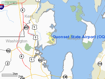
Quonset State Airport (ICAO: KOQU, FAA LID: OQU) is a joint civil-military public airport located on Quonset Point, in northeastern North Kingstown, Rhode Island, adjacent to Narragansett Bay. It is a general aviation airport and there is no scheduled airline service available.
It was the site of the Naval Air Station Quonset Point from 1941 until the early 1970s, when the military presence in Rhode Island was drastically scaled down. Despite the Navy's departure, the airport remains the home of Quonset Point Air National Guard Station and the 143d Airlift Wing (143 AW) of the Rhode Island Air National Guard, flying the C-130J Hercules. The Rhode Island Army National Guard also maintains an Army Aviation Support Facility adjacent to the Air National Guard Station for the 1st Battalion, 126th Aviation Regiment, flying the UH-60 Blackhawk.
Although most U.S. airports use the same three-letter location identifier for the FAA and IATA, Quonset State Airport is assigned OQU by the FAA but has no designation from the IATA.
Quonset State Airport is one of six active airports operated by the Rhode Island Airports Corporation. The other five airports include T.F. Green State Airport, North Central State Airport, Westerly State Airport, Newport State Airport, and Block Island State Airport.
Facilities and aircraft
Quonset State Airport covers an area of 754 acres (305 ha) which contains two asphalt paved runways: 16/34 measuring 7,504 x 150 ft (2,287 x 46 m) and 5/23 measuring 4,000 x 75 ft (1,219 x 23 m).
The airport lies within Class D airspace and has an operating FAA control tower (closed on Mondays).
For the 12-month period ending July 31, 2007, the airport had 20,750 aircraft operations, an average of 56 per day: 68% general aviation, 28% military and 4% air taxi. At that time there were 48 aircraft based at this airport: 60% single-engine, 4% multi-engine, 10% helicopter and 25% military.
The fixed based operator on field is Landmark Aviation, and there is a Cessna Pilot Center flight school, Cindtronix Aviation.
The above content comes from Wikipedia and is published under free licenses – click here to read more.
Location & QuickFacts
| FAA Information Effective: | 2008-09-25 |
| Airport Identifier: | OQU |
| Airport Status: | Operational |
| Longitude/Latitude: | 071-24-43.7000W/41-35-49.7000N
-71.412139/41.597139 (Estimated) |
| Elevation: | 18 ft / 5.49 m (Surveyed) |
| Land: | 754 acres |
| From nearest city: | 3 nautical miles NE of North Kingstown, RI |
| Location: | Washington County, RI |
| Magnetic Variation: | 15W (2000) |
Owner & Manager
| Ownership: | Publicly owned |
| Owner: | Rhode Island Airport Corp |
| Address: | T.f. Green State Airport
Warwick, RI 02806 |
| Phone number: | 401-737-4000 |
| Manager: | Dave Lucas |
| Address: | 210 Airport St
North Kingstown, RI 02852 |
| Phone number: | 401-295-5020 |
Airport Operations and Facilities
| Airport Use: | Open to public |
| Wind indicator: | Yes |
| Segmented Circle: | Yes |
| Control Tower: | Yes |
| Lighting Schedule: | DUSK-DAWN
ACTVT MIRL RY 05/23; HIRL RY 16/34; MALSR RY 16; REIL & PAPI RYS 05 & 23 & TWY LGTS - CTAF. |
| Beacon Color: | Clear-Green (lighted land airport) |
| Landing fee charge: | No
LNDG FEE COMMERCIAL & NON RHODE ISLAND REGISTERED ACFT/OVERNIGHT PARKING FEE. |
| Sectional chart: | New York |
| Region: | ANE - New England |
| Boundary ARTCC: | ZBW - Boston |
| Tie-in FSS: | BDR - Bridgeport |
| FSS on Airport: | No |
| FSS Toll Free: | 1-800-WX-BRIEF |
| NOTAMs Facility: | OQU (NOTAM-d service avaliable) |
| Federal Agreements: | NGPY |
Airport Communications
| CTAF: | 126.350 |
| Unicom: | 122.950 |
Airport Services
| Fuel available: | 100LLA |
| Bottled Oxygen: | NONE |
| Bulk Oxygen: | NONE |
Runway Information
Runway 05/23
| Dimension: | 4000 x 75 ft / 1219.2 x 22.9 m |
| Surface: | ASPH, Good Condition |
| Weight Limit: | Single wheel: 12500 lbs. |
| Edge Lights: | Medium |
| |
Runway 05 |
Runway 23 |
| Longitude: | 071-24-47.4694W | 071-24-17.6735W |
| Latitude: | 41-35-18.9393N | 41-35-51.5188N |
| Elevation: | 11.00 ft | 9.00 ft |
| Alignment: | 34 | 127 |
| Traffic Pattern: | Left | Left |
| Markings: | Basic, Good Condition | Basic, Good Condition |
| Crossing Height: | 40.00 ft | 40.00 ft |
| VASI: | 4-light PAPI on left side | 4-light PAPI on right side |
| Visual Glide Angle: | 3.00° | 3.00° |
| Runway End Identifier: | Yes | Yes |
| Obstruction: | 15 ft pole, 450.0 ft from runway, 100 ft right of centerline, 16:1 slope to clear | , 50:1 slope to clear |
|
Runway 16/34
| Dimension: | 7504 x 150 ft / 2287.2 x 45.7 m |
| Surface: | ASPH, Good Condition |
| Surface Treatment: | Saw-cut or plastic Grooved |
| Weight Limit: | Dual wheel: 175000 lbs. |
| Edge Lights: | High |
| |
Runway 16 |
Runway 34 |
| Longitude: | 071-25-18.0112W | 071-24-21.3713W |
| Latitude: | 41-36-27.8143N | 41-35-27.0825N |
| Elevation: | 18.00 ft | 10.00 ft |
| Alignment: | 127 | 127 |
| ILS Type: | ILS/DME
| |
| Traffic Pattern: | Left | Left |
| Markings: | Precision instrument, Good Condition | Precision instrument, Good Condition |
| Crossing Height: | 58.00 ft | 50.00 ft |
| Displaced threshold: | 0.00 ft | 403.00 ft |
| VASI: | 4-light PAPI on left side | 4-light PAPI on left side |
| Visual Glide Angle: | 3.00° | 3.00° |
| Approach lights: | MALSR | |
| Obstruction: | 38 ft trees, 1400.0 ft from runway, 650 ft left of centerline, 31:1 slope to clear | , 50:1 slope to clear
RWY 34 APCH RATION 50:1 TO DSPLCD THR |
| Decleard distances: | Take off run available 7100.00 ft
Take off distance available 7100.00 ft
Actual stop distance available 7100.00 ft
Landing distance available 7100.00 ft
| Take off run available 7500.00 ft
Take off distance available 7500.00 ft
Actual stop distance available 7500.00 ft
Landing distance available 7100.00 ft
|
|
Radio Navigation Aids
| ID |
Type |
Name |
Ch |
Freq |
Var |
Dist |
| ORW | FAN MARKER | Canton | | | 15W | 35.7 nm |
| SFZ | NDB | Central | | 241.00 | 15W | 19.7 nm |
| TAN | NDB | Taunton | | 227.00 | 16W | 24.4 nm |
| IHM | NDB | Mansfield | | 220.00 | 16W | 26.2 nm |
| FFF | NDB | Plymouth | | 257.00 | 16W | 31.2 nm |
| IMR | NDB | Marshfield | | 368.00 | 16W | 44.7 nm |
| NZW | TACAN | South Weymouth | 061X | | 15W | 39.4 nm |
| FMH | TACAN | Otis | 105X | | 15W | 40.5 nm |
| ORW | VOR/DME | Norwich | 037X | 110.00 | 14W | 26.5 nm |
| SEY | VOR/DME | Sandy Point | 125X | 117.80 | 15W | 26.9 nm |
| PUT | VOR/DME | Putnam | 121X | 117.40 | 14W | 29.0 nm |
| GON | VOR/DME | Groton | 45Y | 110.85 | 14W | 33.0 nm |
| MVY | VOR/DME | Marthas Vineyard | 092X | 114.50 | 15W | 38.0 nm |
| PVD | VORTAC | Providence | 103X | 115.60 | 14W | 7.7 nm |
| BOS | VORTAC | Boston | 074X | 112.70 | 16W | 49.4 nm |
| PVD | VOT | Providence | | 108.20 | | 7.6 nm |
| GON | VOT | Groton | | 110.25 | | 33.1 nm |
| ORH | VOT | Worcester | | 108.20 | | 45.1 nm |
Remarks
- DEER & BIRDS ON & INVOF ARPT.
- ARNG: OPR 1200-2230Z++ TUE-FRI, EXC HOL. LTD TRAN MAINT, FUEL AND PRK AVBL. PPR FUEL DSN 247-4539, C401-275-4539.
- ARNG: TRAN MIL ACFT CTC ARNG OPS 38.95 252.4 IF LDG ARNG RAMP.
- ANG: PPR. OPR 1200-2230Z++ TUE-FRI EXC HOL. TRAN ACFT INBD TO ANG CTC RHODY OPS 15 MIN OUT. ANG OPS DSN 476-3405/3422, C401-886-1405/1422. REQ ALL ACFT CARRYING DISTINGUISHED VISITORS TRANSIT THE ANG RAMP DUR NML DUTY HR.
- ANG: BASH PROGRAM IN EFF. 1 AUG-31 OCT IS DESIGNATED PHASE II FOR BIRD WATCH COND. INCREASED HAZ FR CANADIAN GEESE FLYING E TO W OVER RWY. INBD ACFT CTC TWR FOR LATEST BIRD WATCH COND. NO COMSEC/WEAPONS STRG AVAIL. NO HOT CARGO PRK AVBL.
- ANG: ACFT REQ CUSTOMS/AG CTC RHODY OPS 7 DAYS PRIOR TO ARR.
- TWY R & TWY E CLSD INDEFLY.
- NOISE ABATEMENT PROCS FOR HEAVY ACFT; CONTACT AMGR 401-295-5020. HEAVY ACFT 255000 GWT.
- RY CONDS MAY NOT BE MONITORED OR REPORTED WHEN ARPT IS UNATNDD, CALL AMGR 401-295-5020.
- LGTD CRANES 125 FT HIGH AT PIER 1,000 FT SE OF RY 05.
- FUEL: J8(MIL) A+ (LANDMARK AVIATION, OPR 1100-0200Z++. PPR MANDATORY DUR NON-DUTY HR. CTC C401-295-5020 EXTN 3008.) (NC-100LL, A)
- RSTD: 180‘ TURNS FOR ACFT OVER 12,500 LB GWT PROH ON RWY 16-34.
Images and information placed above are from
http://www.airport-data.com/airport/OQU/
We thank them for the data!
| General Info
|
| Country |
United States
|
| State |
RHODE ISLAND
|
| FAA ID |
OQU
|
| Latitude |
41-35-49.700N
|
| Longitude |
071-24-43.700W
|
| Elevation |
18 feet
|
| Near City |
NORTH KINGSTOWN
|
We don't guarantee the information is fresh and accurate. The data may
be wrong or outdated.
For more up-to-date information please refer to other sources.
|
|


