 |
|
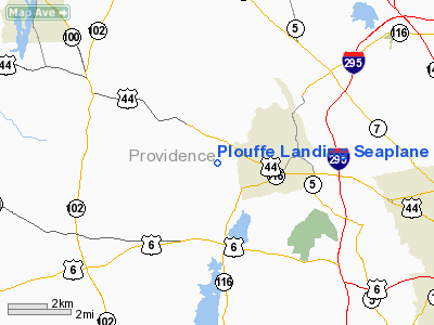
Plouffe Landing Seaplane Base Airport |
Location & QuickFacts
| FAA Information Effective: | 2008-09-25 |
| Airport Identifier: | RI28 |
| Airport Status: | Operational |
| Longitude/Latitude: | 071-35-25.0800W/41-52-31.0200N
-71.590300/41.875283 (Estimated) |
| Elevation: | 328 ft / 99.97 m (Estimated) |
| Land: | 0 acres |
| From nearest city: | 0 nautical miles N of Glouster, RI |
| Location: | Providence County, RI |
| Magnetic Variation: | () |
Owner & Manager
| Ownership: | Privately owned |
| Owner: | Myron Mitchell |
| Address: | 76 Aldrich Road
North Scituate, RI 02857 |
| Phone number: | 401-738-7250 |
| Manager: | Myron Mitchell |
| Address: | 76 Aldrich Road
North Scituate, RI 02857 |
| Phone number: | 401-738-7250 |
Airport Operations and Facilities
| Airport Use: | Private |
| Control Tower: | No |
| Sectional chart: | New York |
| Region: | ANE - New England |
| Boundary ARTCC: | ZBW - Boston |
| Tie-in FSS: | BDR - Bridgeport |
| FSS Toll Free: | 1-800-WX-BRIEF |
Runway Information
Runway 06W/24W
| Dimension: | 3100 x 100 ft / 944.9 x 30.5 m |
| Surface: | WATER, |
| |
Runway 06W |
Runway 24W |
| Traffic Pattern: | Left | Left |
|
Runway 13W/31W
| Dimension: | 5000 x 100 ft / 1524.0 x 30.5 m |
| Surface: | WATER, |
| |
Runway 13W |
Runway 31W |
| Traffic Pattern: | Left | Left |
|
Runway 16W/34W
| Dimension: | 2200 x 100 ft / 670.6 x 30.5 m |
| Surface: | WATER, |
| |
Runway 16W |
Runway 34W |
| Traffic Pattern: | Left | Left |
|
Radio Navigation Aids
| ID |
Type |
Name |
Ch |
Freq |
Var |
Dist |
| ORW | FAN MARKER | Canton | | | 15W | 25.9 nm |
| SFZ | NDB | Central | | 241.00 | 15W | 5.3 nm |
| IHM | NDB | Mansfield | | 220.00 | 16W | 19.2 nm |
| TAN | NDB | Taunton | | 227.00 | 16W | 25.7 nm |
| FFF | NDB | Plymouth | | 257.00 | 16W | 35.3 nm |
| SKR | NDB | Shaker Hill | | 251.00 | 16W | 39.4 nm |
| FIT | NDB | Fitchburg | | 365.00 | 15W | 41.3 nm |
| IMR | NDB | Marshfield | | 368.00 | 16W | 43.0 nm |
| LQ | NDB | Lyndy | | 382.00 | 16W | 44.5 nm |
| HF | NDB | Lomis | | 244.00 | 15W | 48.6 nm |
| NZW | TACAN | South Weymouth | 061X | | 15W | 33.5 nm |
| FMH | TACAN | Otis | 105X | | 15W | 50.0 nm |
| PUT | VOR/DME | Putnam | 121X | 117.40 | 14W | 12.3 nm |
| ORW | VOR/DME | Norwich | 037X | 110.00 | 14W | 26.5 nm |
| GON | VOR/DME | Groton | 45Y | 110.85 | 14W | 38.8 nm |
| SEY | VOR/DME | Sandy Point | 125X | 117.80 | 15W | 42.6 nm |
| HFD | VOR/DME | Hartford | 096X | 114.90 | 13W | 45.2 nm |
| PVD | VORTAC | Providence | 103X | 115.60 | 14W | 11.6 nm |
| BOS | VORTAC | Boston | 074X | 112.70 | 16W | 39.5 nm |
| GDM | VORTAC | Gardner | 043X | 110.60 | 14W | 45.4 nm |
| CEF | VORTAC | Westover | 87X | 114.00 | 14W | 46.1 nm |
| BDL | VORTAC | Bradley | 027X | 109.00 | 14W | 49.3 nm |
| PVD | VOT | Providence | | 108.20 | | 11.7 nm |
| ORH | VOT | Worcester | | 108.20 | | 26.6 nm |
| BED | VOT | Laurence G Hanscom Fld | | 110.00 | | 38.1 nm |
| GON | VOT | Groton | | 110.25 | | 39.0 nm |
| BOS | VOT | Boston Logan Intl | | 111.00 | | 39.4 nm |
| HFD | VOT | Hartford | | 108.20 | | 48.3 nm |
| BDL | VOT | Bradley Intl | | 111.40 | | 49.0 nm |
Remarks
- 50 FT TREES ALL QUADRANTS.
- PRVDD VFR OPNS, PR USE, RESOLVE ANY TRAFFIC PATTERN CONFLICTS WITH AIRPORTS WITHIN 5 NM.
Images and information placed above are from
http://www.airport-data.com/airport/RI28/
We thank them for the data!
|
|


