 |
|
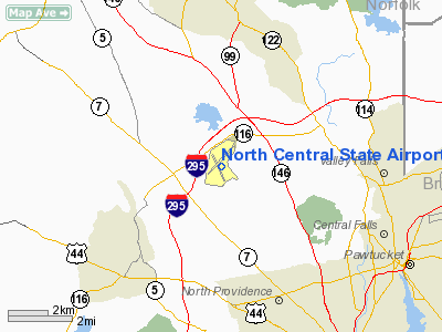
North Central State Airport |
| North Central State Airport |
 |
| CAP aerial photo, eastern view |
| IATA: SFZ – ICAO: KSFZ – FAA LID: SFZ |
| Summary |
| Airport type |
Public |
| Owner |
State of Rhode Island |
| Operator |
Rhode Island Airport Corp. |
| Serves |
Pawtucket, Rhode Island |
| Location |
Smithfield / Lincoln |
| Elevation AMSL |
441 ft / 134 m |
| Coordinates |
41°55′15″N 071°29′29″W / 41.92083°N 71.49139°W / 41.92083; -71.49139 |
| Runways |
| Direction |
Length |
Surface |
| ft |
m |
| 5/23 |
5,000 |
1,524 |
Asphalt |
| 15/33 |
3,210 |
978 |
Asphalt |
| Statistics (2007) |
| Aircraft operations |
27,181 |
| Based aircraft |
120 |
| Source: Federal Aviation Administration |
North Central State Airport (IATA: SFZ, ICAO: KSFZ, FAA LID: SFZ) is a public use airport in Providence County, Rhode Island, United States. The airport is owned by the State of Rhode Island and opened for service in 1951. It serves the city of Pawtucket and is located three nautical miles (6 km) east of its central business district.
The airport is situated in the towns of Smithfield and Lincoln. It is located in the upper region of the state and is roughly horizontally centered in the state, hence the name "North Central". It is designated as a reliever airport for general aviation activity from T.F. Green Airport.
North Central State Airport is one of six active airports operated by the Rhode Island Airport Corporation, the other five being T.F. Green State Airport, Quonset State Airport, Westerly State Airport, Newport State Airport, and Block Island State Airport. Facilities and aircraft
North Central State Airport covers an area of 475 acres (192 ha) at an elevation of 441 feet (134 m) above mean sea level. It has two asphalt paved runways: 5/23 is 5,000 by 100 feet (1,524 x 30 m) and 15/33 is 3,210 by 75 feet (978 x 23 m). Runway 5/23 is used more often than Runway 15/33 due to crosswinds.
For the 12-month period ending November 30, 2007, the airport had 27,181 aircraft operations, an average of 74 per day: 99% general aviation, 1% air taxi and <1% military. At that time there were 120 aircraft based at this airport: 92.5% single-engine and 7.5% multi-engine.
It is a non-towered airport and generally caters to private pilots and general aviation, and the aircraft that are seen there are usually either piston or light jet aircraft. The airport is not able to serve large airliners, and the use of North Central to these types of aircraft is purely emergency-related. The airport is the base for a repair facility.
Airlines
- Angel Flight America Lancaster
- Flight Options Oxford
The above content comes from Wikipedia and is published under free licenses – click here to read more.
Location & QuickFacts
| FAA Information Effective: | 2008-09-25 |
| Airport Identifier: | SFZ |
| Airport Status: | Operational |
| Longitude/Latitude: | 071-29-28.9730W/41-55-14.7480N
-71.491381/41.920763 (Estimated) |
| Elevation: | 441 ft / 134.42 m (Surveyed) |
| Land: | 475 acres |
| From nearest city: | 3 nautical miles E of Pawtucket, RI |
| Location: | Providence County, RI |
| Magnetic Variation: | 15W (1995) |
Owner & Manager
| Ownership: | Publicly owned |
| Owner: | State Of Rhode Island |
| Address: | T.f.green Arpt
Warwick, RI 02886 |
| Phone number: | 401-737-4000 |
| Manager: | Paul Smith |
| Address: | 210 Airport Rd
North Kingstown, RI 02852 |
| Phone number: | 401-333-8503 |
Airport Operations and Facilities
| Airport Use: | Open to public |
| Wind indicator: | Yes |
| Segmented Circle: | Yes |
| Control Tower: | No |
| Lighting Schedule: | DUSK-DAWN
ACTVT HIRL RY 05/23 & MIRL RY 15/33; PAPI RY 15 & 23; MALS RY 05 & REIL RYS 23 & 15/33 & TWY LGTS A B C & D - CTAF. |
| Beacon Color: | Clear-Green (lighted land airport) |
| Landing fee charge: | Yes
LDG FEE FOR COML ACFT & NON-RHODE ISLAND REGISTERED ACFT. |
| Sectional chart: | New York |
| Region: | ANE - New England |
| Boundary ARTCC: | ZBW - Boston |
| Tie-in FSS: | BDR - Bridgeport |
| FSS on Airport: | No |
| FSS Toll Free: | 1-800-WX-BRIEF |
| NOTAMs Facility: | SFZ (NOTAM-d service avaliable) |
| Federal Agreements: | NGY |
Airport Communications
| CTAF: | 123.075 |
| Unicom: | 123.075 |
Airport Services
| Fuel available: | 100LLA |
| Airframe Repair: | MAJOR |
| Power Plant Repair: | MAJOR |
| Bottled Oxygen: | NONE |
| Bulk Oxygen: | NONE |
Runway Information
Runway 05/23
| Dimension: | 5000 x 100 ft / 1524.0 x 30.5 m |
| Surface: | ASPH, |
| Weight Limit: | Single wheel: 30000 lbs.
Dual wheel: 60000 lbs. |
| Edge Lights: | High |
| |
Runway 05 |
Runway 23 |
| Longitude: | 071-29-44.9670W | 071-29-09.8510W |
| Latitude: | 41-54-59.8880N | 41-55-41.7420N |
| Elevation: | 419.00 ft | 420.00 ft |
| Alignment: | 32 | 127 |
| ILS Type: | LOC/DME
| |
| Traffic Pattern: | Left | Left |
| Markings: | Non-precision instrument, Good Condition | Non-precision instrument, Good Condition |
| Crossing Height: | 52.00 ft | 35.00 ft |
| VASI: | 4-box on right side | 4-light PAPI on left side |
| Visual Glide Angle: | 3.00° | 3.00° |
| Approach lights: | MALS | |
| Runway End Identifier: | | Yes |
| Obstruction: | 42 ft trees, 1800.0 ft from runway, 200 ft left of centerline, 38:1 slope to clear | 13 ft trees, 600.0 ft from runway, 150 ft right of centerline, 30:1 slope to clear |
|
Runway 15/33
| Dimension: | 3210 x 75 ft / 978.4 x 22.9 m |
| Surface: | ASPH, Good Condition |
| Weight Limit: | Single wheel: 12500 lbs. |
| Edge Lights: | Medium |
| |
Runway 15 |
Runway 33 |
| Longitude: | 071-29-45.1730W | 071-29-17.6430W |
| Latitude: | 41-55-17.3690N | 41-54-53.2260N |
| Elevation: | 426.00 ft | 440.00 ft |
| Alignment: | 127 | 127 |
| Traffic Pattern: | Left | Left |
| Markings: | Basic, Good Condition | Basic, Good Condition |
| Crossing Height: | 35.00 ft | 0.00 ft |
| VASI: | 4-light PAPI on right side | |
| Visual Glide Angle: | 3.50° | 0.00° |
| Runway End Identifier: | Yes | Yes |
| Obstruction: | 33 ft trees, 1000.0 ft from runway, 400 ft right of centerline, 24:1 slope to clear | 55 ft trees, 1200.0 ft from runway, 200 ft left of centerline, 18:1 slope to clear |
|
Radio Navigation Aids
| ID |
Type |
Name |
Ch |
Freq |
Var |
Dist |
| ORW | FAN MARKER | Canton | | | 15W | 20.8 nm |
| BVY | FAN MARKER | Beverly | | | | 48.1 nm |
| SFZ | NDB | Central | | 241.00 | 15W | 0.2 nm |
| IHM | NDB | Mansfield | | 220.00 | 16W | 14.0 nm |
| TAN | NDB | Taunton | | 227.00 | 16W | 21.4 nm |
| FFF | NDB | Plymouth | | 257.00 | 16W | 31.1 nm |
| SKR | NDB | Shaker Hill | | 251.00 | 16W | 35.0 nm |
| IMR | NDB | Marshfield | | 368.00 | 16W | 38.0 nm |
| LQ | NDB | Lyndy | | 382.00 | 16W | 39.7 nm |
| FIT | NDB | Fitchburg | | 365.00 | 15W | 39.7 nm |
| TOF | NDB | Topsfield | | 269.00 | 16W | 48.3 nm |
| NZW | TACAN | South Weymouth | 061X | | 15W | 28.3 nm |
| FMH | TACAN | Otis | 105X | | 15W | 46.5 nm |
| PUT | VOR/DME | Putnam | 121X | 117.40 | 14W | 15.9 nm |
| ORW | VOR/DME | Norwich | 037X | 110.00 | 14W | 31.6 nm |
| GON | VOR/DME | Groton | 45Y | 110.85 | 14W | 43.5 nm |
| SEY | VOR/DME | Sandy Point | 125X | 117.80 | 15W | 45.4 nm |
| PVD | VORTAC | Providence | 103X | 115.60 | 14W | 12.1 nm |
| BOS | VORTAC | Boston | 074X | 112.70 | 16W | 34.5 nm |
| GDM | VORTAC | Gardner | 043X | 110.60 | 14W | 45.3 nm |
| CEF | VORTAC | Westover | 87X | 114.00 | 14W | 49.1 nm |
| PVD | VOT | Providence | | 108.20 | | 12.2 nm |
| ORH | VOT | Worcester | | 108.20 | | 26.8 nm |
| BED | VOT | Laurence G Hanscom Fld | | 110.00 | | 34.1 nm |
| BOS | VOT | Boston Logan Intl | | 111.00 | | 34.5 nm |
| GON | VOT | Groton | | 110.25 | | 43.7 nm |
Remarks
- FOR NOISE ABATEMENT; AIRCRAFT DEPARTING RWY 23 MAINTAIN RWY HEADING FOR 1.1 MILES PRIOR TO TURN OUT.
- LIGHTED 250' MSL TOWER 3-2/5 MILES SE.
- DEER & BIRDS ON & INVOF ARPT.
- RY 23 INTERSECTION DEP NOT AUTHORIZED.
- OVERNIGHT PARKING FEE.
- EXISTED PRIOR TO 1959.
Images and information placed above are from
http://www.airport-data.com/airport/SFZ/
We thank them for the data!
| General Info
|
| Country |
United States
|
| State |
RHODE ISLAND
|
| FAA ID |
SFZ
|
| Latitude |
41-55-14.748N
|
| Longitude |
071-29-28.973W
|
| Elevation |
441 feet
|
| Near City |
PAWTUCKET
|
We don't guarantee the information is fresh and accurate. The data may
be wrong or outdated.
For more up-to-date information please refer to other sources.
|
|


