 |
|
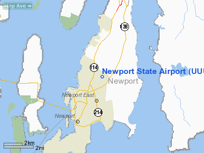
| Newport State Airport |
| IATA: NPT – ICAO: KUUU – FAA LID: UUU |
| Summary |
| Airport type |
Public |
| Owner |
Rhode Island Airport Corp. |
| Serves |
Newport, Rhode Island |
| Location |
Middletown, Rhode Island |
| Elevation AMSL |
172 ft / 52 m |
| Coordinates |
41°31′57″N 071°16′54″W / 41.5325°N 71.28167°W / 41.5325; -71.28167 |
| Runways |
| Direction |
Length |
Surface |
| ft |
m |
| 4/22 |
2,999 |
914 |
Asphalt |
| 16/34 |
2,623 |
799 |
Asphalt |
| Statistics (2008) |
| Aircraft operations |
25,853 |
| Based aircraft |
43 |
| Source: Federal Aviation Administration |
Newport State Airport (IATA: NPT, ICAO: KUUU, FAA LID: UUU) is a public use airport in Newport County, Rhode Island, United States. It serves the city of Newport and is located two nautical miles (3.7 km) northeast of its central business district. There is no scheduled airline service available, but it once was served by Air New England.
Although most U.S. airports use the same three-letter location identifier for the FAA and IATA, Newport State Airport is assigned UUU by the FAA and NPT by the IATA (which assigned UUU to Manumu, Papua-New Guinea).
Newport State Airport is one of six active airports operated by the Rhode Island Airport Corporation, the other five being T.F. Green State Airport, North Central State Airport, Westerly State Airport, Quonset State Airport, and Block Island State Airport. History
The airport site was acquired by the state in July 1960, and construction of the runways and taxiways was completed by September 1967. At least one runway was operational by July 1964, when the first aircraft accident at the Newport airport (a gear-up landing) was documented by the National Transportation Safety Board. The first fatal accident at Newport State Airport was a mid-air collision between two general aviation aircraft on April 23, 1969.
Facilities and aircraft
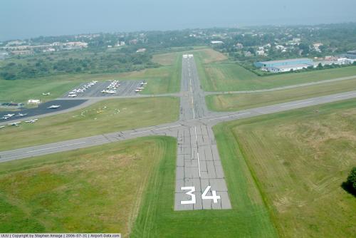
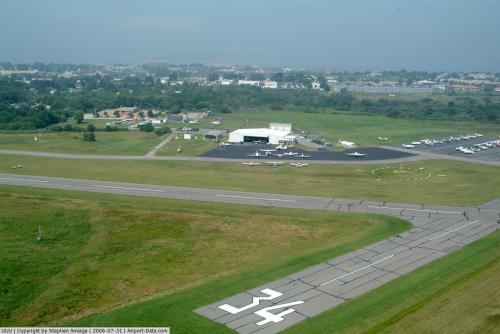
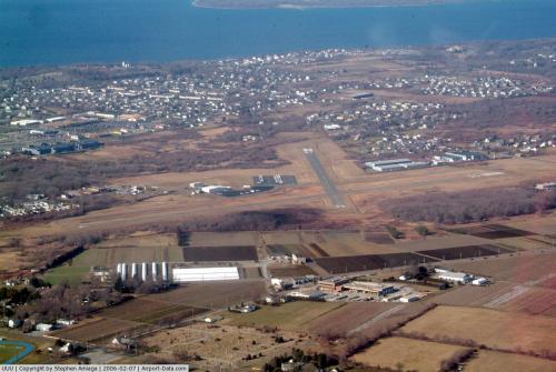
Newport State Airport covers an area of 221 acres (89 ha) at an elevation of 172 feet (52 m) above mean sea level. It has two asphalt paved runways: 4/22 is 2,999 by 75 feet (914 x 23 m) and 16/34 is 2,623 by 75 feet (799 x 23 m).
Airlines
For the 12-month period ending June 30, 2008, the airport had 25,853 aircraft operations, an average of 70 per day: 99% general aviation, 1% air taxi and <1% military. At that time there were 43 aircraft based at this airport: 88% single-engine, 9% multi-engine and 2% helicopter.
The above content comes from Wikipedia and is published under free licenses – click here to read more.
 |
(Click on the photo to enlarge) |
 |
(Click on the photo to enlarge) |
 |
(Click on the photo to enlarge) |
Location & QuickFacts
| FAA Information Effective: | 2008-09-25 |
| Airport Identifier: | UUU |
| Airport Status: | Operational |
| Longitude/Latitude: | 071-16-53.5580W/41-31-56.7830N
-71.281544/41.532440 (Estimated) |
| Elevation: | 172 ft / 52.43 m (Surveyed) |
| Land: | 221 acres |
| From nearest city: | 2 nautical miles NE of Newport, RI |
| Location: | Newport County, RI |
| Magnetic Variation: | 15W (1995) |
Owner & Manager
| Ownership: | Publicly owned |
| Owner: | State Of Rhode Island/riac |
| Address: | T.f.green Arpt
Warwick, RI 02886 |
| Phone number: | 401-737-4000 |
| Manager: | Branden Michaux |
| Address: | Newport State Arpt
Middletown, RI 02840 |
| Phone number: | 401-846-9400 |
Airport Operations and Facilities
| Airport Use: | Open to public |
| Wind indicator: | Yes |
| Segmented Circle: | Yes |
| Control Tower: | No |
| Lighting Schedule: | DUSK-DAWN
ACTVT MIRL RYS 04/22 & 16/34; REIL RY 22; TWYS A; B; C & RAMP AREA - CTAF. |
| Beacon Color: | Clear-Green (lighted land airport) |
| Landing fee charge: | Yes
OVNGT PARKING FEE. LNDG FEE COML & NON RI REG ACFT. |
| Sectional chart: | New York |
| Region: | ANE - New England |
| Boundary ARTCC: | ZBW - Boston |
| Tie-in FSS: | BDR - Bridgeport |
| FSS on Airport: | No |
| FSS Toll Free: | 1-800-WX-BRIEF |
| NOTAMs Facility: | UUU (NOTAM-d service avaliable) |
| Federal Agreements: | NGY |
Airport Communications
| CTAF: | 122.800 |
| Unicom: | 122.800 |
Airport Services
| Fuel available: | 100LL
FUEL AVBL 24 HRS BY CREDIT CARD. |
| Airframe Repair: | MAJOR |
| Power Plant Repair: | MAJOR |
| Bottled Oxygen: | NONE |
| Bulk Oxygen: | NONE |
Runway Information
Runway 04/22
| Dimension: | 2999 x 75 ft / 914.1 x 22.9 m |
| Surface: | ASPH, Fair Condition |
| Weight Limit: | Single wheel: 30000 lbs. |
| Edge Lights: | Medium |
| |
Runway 04 |
Runway 22 |
| Longitude: | 071-16-58.9970W | 071-16-43.0760W |
| Latitude: | 41-31-39.2980N | 41-32-06.4010N |
| Elevation: | 148.00 ft | 172.00 ft |
| Alignment: | 24 | 127 |
| ILS Type: | | LOC/DME
|
| Traffic Pattern: | Left | Left |
| Markings: | Basic, Fair Condition | Non-precision instrument, Fair Condition |
| Crossing Height: | 51.00 ft | 30.00 ft |
| VASI: | 4-box on left side | 4-light PAPI on left side |
| Visual Glide Angle: | 4.00° | 4.00° |
| Runway End Identifier: | No | Yes |
| Obstruction: | 69 ft trees, 1250.0 ft from runway, 150 ft left of centerline, 15:1 slope to clear | 38 ft trees, 1000.0 ft from runway, 200 ft right of centerline, 21:1 slope to clear |
|
Runway 16/34
| Dimension: | 2623 x 75 ft / 799.5 x 22.9 m |
| Surface: | ASPH, Fair Condition |
| Weight Limit: | Single wheel: 30000 lbs. |
| Edge Lights: | Medium |
| |
Runway 16 |
Runway 34 |
| Longitude: | 071-17-06.6880W | 071-16-46.1900W |
| Latitude: | 41-32-11.7010N | 41-31-50.8570N |
| Elevation: | 146.00 ft | 161.00 ft |
| Alignment: | 127 | 127 |
| Traffic Pattern: | Left | Left |
| Markings: | Non-precision instrument, Fair Condition | Basic, Fair Condition |
| Crossing Height: | 40.00 ft | 0.00 ft |
| VASI: | 4-box on left side | |
| Visual Glide Angle: | 3.75° | 0.00° |
| Runway End Identifier: | No | No |
| Obstruction: | 52 ft trees, 1250.0 ft from runway, 20 ft left of centerline, 20:1 slope to clear | 37 ft trees, 900.0 ft from runway, 200 ft left of centerline, 18:1 slope to clear |
|
Radio Navigation Aids
| ID |
Type |
Name |
Ch |
Freq |
Var |
Dist |
| ORW | FAN MARKER | Canton | | | 15W | 38.1 nm |
| TAN | NDB | Taunton | | 227.00 | 16W | 23.8 nm |
| SFZ | NDB | Central | | 241.00 | 15W | 25.0 nm |
| IHM | NDB | Mansfield | | 220.00 | 16W | 28.5 nm |
| FFF | NDB | Plymouth | | 257.00 | 16W | 28.6 nm |
| IMR | NDB | Marshfield | | 368.00 | 16W | 43.5 nm |
| FMH | TACAN | Otis | 105X | | 15W | 35.3 nm |
| NZW | TACAN | South Weymouth | 061X | | 15W | 40.1 nm |
| SEY | VOR/DME | Sandy Point | 125X | 117.80 | 15W | 25.7 nm |
| MVY | VOR/DME | Marthas Vineyard | 092X | 114.50 | 15W | 31.2 nm |
| ORW | VOR/DME | Norwich | 037X | 110.00 | 14W | 32.3 nm |
| PUT | VOR/DME | Putnam | 121X | 117.40 | 14W | 35.8 nm |
| GON | VOR/DME | Groton | 45Y | 110.85 | 14W | 36.8 nm |
| PVD | VORTAC | Providence | 103X | 115.60 | 14W | 13.3 nm |
| PVD | VOT | Providence | | 108.20 | | 13.2 nm |
| GON | VOT | Groton | | 110.25 | | 36.8 nm |
Remarks
- DEER & BIRDS ON & INVOF ARPT.
- RY CONDS MAY NOT BE MONITORED OR REPORTED WHEN ARPT IS UNATNDD, CALL AMGR 401-295-5020.
Images and information placed above are from
http://www.airport-data.com/airport/UUU/
We thank them for the data!
| General Info
|
| Country |
United States
|
| State |
RHODE ISLAND
|
| FAA ID |
UUU
|
| Latitude |
41-31-56.783N
|
| Longitude |
071-16-53.558W
|
| Elevation |
172 feet
|
| Near City |
NEWPORT
|
We don't guarantee the information is fresh and accurate. The data may
be wrong or outdated.
For more up-to-date information please refer to other sources.
|
|


