 |
|
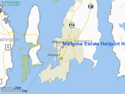
Malbone Estate Heliport Heliport |
Location & QuickFacts
| FAA Information Effective: | 2008-09-25 |
| Airport Identifier: | 2RI7 |
| Airport Status: | Operational |
| Longitude/Latitude: | 071-18-40.7300W/41-30-23.2000N
-71.311314/41.506444 (Estimated) |
| Elevation: | 83 ft / 25.30 m (Estimated) |
| Land: | 0 acres |
| From nearest city: | 2 nautical miles SW of Newport, RI |
| Location: | Newport County, RI |
| Magnetic Variation: | 15W (2000) |
Owner & Manager
| Ownership: | Privately owned |
| Owner: | Malbone Road Trust |
| Address: | Malbone Estate, Malbone Road
Newport, RI 02840 |
| Phone number: | 401-848-0054 |
| Manager: | James H. Leach |
| Address: | Malbone Estate, Malbone Road
Newport, RI 02840 |
| Phone number: | 401-848-0054 |
Airport Operations and Facilities
| Airport Use: | Private |
| Wind indicator: | Yes |
| Segmented Circle: | No |
| Control Tower: | No |
| Sectional chart: | New York |
| Region: | ANE - New England |
| Boundary ARTCC: | ZBW - Boston |
| Tie-in FSS: | BDR - Bridgeport |
| FSS Toll Free: | 1-800-WX-BRIEF |
Runway Information
Helipad H1
| Dimension: | 50 x 150 ft / 15.2 x 45.7 m |
| Surface: | TURF, |
| |
Runway H1 |
Runway |
| Traffic Pattern: | Left | Left |
|
Radio Navigation Aids
| ID |
Type |
Name |
Ch |
Freq |
Var |
Dist |
| ORW | FAN MARKER | Canton | | | 15W | 39.8 nm |
| TAN | NDB | Taunton | | 227.00 | 16W | 25.9 nm |
| SFZ | NDB | Central | | 241.00 | 15W | 26.0 nm |
| IHM | NDB | Mansfield | | 220.00 | 16W | 30.3 nm |
| FFF | NDB | Plymouth | | 257.00 | 16W | 30.7 nm |
| IMR | NDB | Marshfield | | 368.00 | 16W | 45.6 nm |
| FMH | TACAN | Otis | 105X | | 15W | 37.0 nm |
| NZW | TACAN | South Weymouth | 061X | | 15W | 42.1 nm |
| SEY | VOR/DME | Sandy Point | 125X | 117.80 | 15W | 23.6 nm |
| ORW | VOR/DME | Norwich | 037X | 110.00 | 14W | 31.1 nm |
| MVY | VOR/DME | Marthas Vineyard | 092X | 114.50 | 15W | 32.2 nm |
| GON | VOR/DME | Groton | 45Y | 110.85 | 14W | 35.0 nm |
| PUT | VOR/DME | Putnam | 121X | 117.40 | 14W | 36.0 nm |
| PVD | VORTAC | Providence | 103X | 115.60 | 14W | 14.1 nm |
| PVD | VOT | Providence | | 108.20 | | 14.0 nm |
| GON | VOT | Groton | | 110.25 | | 35.1 nm |
Remarks
- PRVDD VFR DALGT ONLY, REMAIN CLEAR OF NEWPORT STATE AIRPORT, DEVELOP INGRESS/EGRESS ROUTES WHICH MINIMIZE OPNS OVER DENSELY POPULATED AREAS, INSTALL WIND INDICATOR ABOVE TREE HEIGHT, NOTIFY USERS OF ABOVE.
Images and information placed above are from
http://www.airport-data.com/airport/2RI7/
We thank them for the data!
| General Info
|
| Country |
United States
|
| State |
RHODE ISLAND
|
| FAA ID |
2RI7
|
| Latitude |
41-30-23.200N
|
| Longitude |
071-18-40.730W
|
| Elevation |
83 feet
|
| Near City |
NEWPORT
|
We don't guarantee the information is fresh and accurate. The data may
be wrong or outdated.
For more up-to-date information please refer to other sources.
|
|


