 |
|
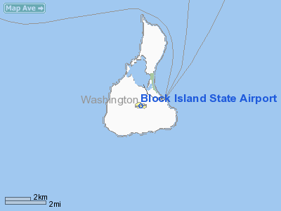
Block Island State Airport |
| Block Island State Airport |
| IATA: BID – ICAO: KBID – FAA LID: BID |
| Summary |
| Airport type |
Public |
| Owner |
State of Rhode Island |
| Operator |
Rhode Island Airport Corp. |
| Serves |
Block Island, Rhode Island |
| Elevation AMSL |
108 ft / 33 m |
| Coordinates |
41°10′05″N 071°34′40″W / 41.16806°N 71.57778°W / 41.16806; -71.57778 |
| Runways |
| Direction |
Length |
Surface |
| ft |
m |
| 10/28 |
2,502 |
763 |
Asphalt |
| Statistics (2007) |
| Aircraft operations |
14,076 |
| Based aircraft |
6 |
| Source: Federal Aviation Administration |
Block Island State Airport (IATA: BID, ICAO: KBID) is a public airport located on Block Island, in Washington County, Rhode Island, United States. The airport is owned by the State of Rhode Island. It is primarily a general aviation airport, but there is also scheduled airline service to Westerly State Airport. The airport opened in 1950.
Block Island State Airport is one of six active airports operated by the Rhode Island Airport Corporation, the other five being T.F. Green State Airport, Newport State Airport, North Central State Airport, Quonset State Airport and Westerly State Airport. Facilities and aircraft
Block Island State Airport covers an area of 136 acres (55 ha) at an elevation of 108 feet (33 m) above mean sea level. It has one runway designated 10/28 with an asphalt surface measuring 2,502 by 100 feet (763 x 30 m).
For the 12-month period ending August 30, 2007, the airport had 14,076 aircraft operations, an average of 38 per day: 54% general aviation, 46% air taxi and <1% military. At that time there were 6 aircraft based at this airport: 83% single-engine and 17% multi-engine.
Airline and destinations
- New England Airlines (Westerly)
The above content comes from Wikipedia and is published under free licenses – click here to read more.
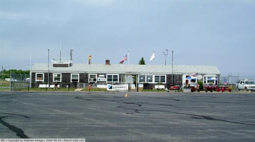 |
(Click on the photo to enlarge) |
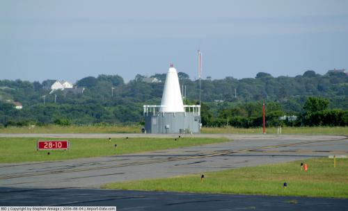 |
(Click on the photo to enlarge) |
Location & QuickFacts
| FAA Information Effective: | 2008-09-25 |
| Airport Identifier: | BID |
| Airport Status: | Operational |
| Longitude/Latitude: | 071-34-40.2000W/41-10-05.2000N
-71.577833/41.168111 (Estimated) |
| Elevation: | 108 ft / 32.92 m (Surveyed) |
| Land: | 136 acres |
| From nearest city: | 1 nautical miles W of Block Island, RI |
| Location: | Washington County, RI |
| Magnetic Variation: | 15W (1985) |
Owner & Manager
| Ownership: | Publicly owned |
| Owner: | State Of Rhode Island |
| Address: | Ri Airport Corp
Warwick, RI 02886 |
| Phone number: | 401-737-4000 |
| Manager: | Tom Brown |
| Address: | Box 357
Block Island, RI 02807 |
| Phone number: | 401-466-5511 |
Airport Operations and Facilities
| Airport Use: | Open to public |
| Wind indicator: | Yes |
| Segmented Circle: | Yes |
| Control Tower: | No |
| Lighting Schedule: | DUSK-DAWN
ACTVT MIRL RY 10/28; MALSF RY 10 & REIL & PAPI RYS 10 & 28 - CTAF. |
| Beacon Color: | Clear-Green (lighted land airport) |
| Landing fee charge: | Yes
COMMERCIAL & NON RHODE ISLAND REGISTERED ACFT. |
| Sectional chart: | New York |
| Region: | ANE - New England |
| Boundary ARTCC: | ZBW - Boston |
| Tie-in FSS: | BDR - Bridgeport |
| FSS on Airport: | No |
| FSS Toll Free: | 1-800-WX-BRIEF |
| NOTAMs Facility: | BID (NOTAM-d service avaliable) |
| Federal Agreements: | NGY |
Airport Communications
| CTAF: | 123.000 |
| Unicom: | 123.000 |
Airport Services
| Bottled Oxygen: | NONE |
| Bulk Oxygen: | NONE |
Runway Information
Runway 10/28
| Dimension: | 2502 x 100 ft / 762.6 x 30.5 m |
| Surface: | ASPH, |
| Weight Limit: | Single wheel: 30000 lbs. |
| Edge Lights: | Medium |
| |
Runway 10 |
Runway 28 |
| Longitude: | 071-34-56.4903W | 071-34-23.9680W |
| Latitude: | 41-10-03.8872N | 41-10-06.5646N |
| Elevation: | 108.00 ft | 101.00 ft |
| Alignment: | 84 | 127 |
| Traffic Pattern: | Left | Left |
| Markings: | Non-precision instrument, Good Condition | Non-precision instrument, Good Condition |
| Crossing Height: | 40.00 ft | 35.00 ft |
| VASI: | 4-light PAPI on right side | 4-light PAPI on left side |
| Visual Glide Angle: | 3.00° | 3.00° |
| Approach lights: | MALSF | |
| Runway End Identifier: | | Yes |
| Obstruction: | 88 ft trees, 2000.0 ft from runway, 400 ft right of centerline, 20:1 slope to clear | , 50:1 slope to clear |
|
Radio Navigation Aids
| ID |
Type |
Name |
Ch |
Freq |
Var |
Dist |
| SFZ | NDB | Central | | 241.00 | 15W | 45.3 nm |
| TAN | NDB | Taunton | | 227.00 | 16W | 49.5 nm |
| GON | VOR/DME | Groton | 45Y | 110.85 | 14W | 23.5 nm |
| ORW | VOR/DME | Norwich | 037X | 110.00 | 14W | 30.1 nm |
| MVY | VOR/DME | Marthas Vineyard | 092X | 114.50 | 15W | 45.7 nm |
| PUT | VOR/DME | Putnam | 121X | 117.40 | 14W | 48.8 nm |
| PVD | VORTAC | Providence | 103X | 115.60 | 14W | 34.1 nm |
| HTO | VORTAC | Hampton | 083X | 113.60 | 13W | 36.7 nm |
| GON | VOT | Groton | | 110.25 | | 23.4 nm |
| PVD | VOT | Providence | | 108.20 | | 34.1 nm |
Remarks
- OBSTRUCTIONS LGTD TOWERS 1 MILE NE OF ARPT 1/2 MILE APART.
- DEER & BIRDS ON & INVOF ARPT.
- ARPT PARKING & SAFETY BRIEF AVBL ON LANDING 122.85 MHZ OR CALL 401-466-5511.
- RY CONDS MAY NOT BE MONITORED OR REPORTED WHEN ARPT IS UNATNDD; CALL AMGR 401-466-5511.
- OVERNIGHT PARKING FEE.
- EXISTED PRIOR TO 1959.
Images and information placed above are from
http://www.airport-data.com/airport/BID/
We thank them for the data!
| General Info
|
| Country |
United States
|
| State |
RHODE ISLAND
|
| FAA ID |
BID
|
| Latitude |
41-10-05.228N
|
| Longitude |
071-34-40.230W
|
| Elevation |
109 feet
|
| Near City |
BLOCK ISLAND
|
We don't guarantee the information is fresh and accurate. The data may
be wrong or outdated.
For more up-to-date information please refer to other sources.
|
|


