 |
|
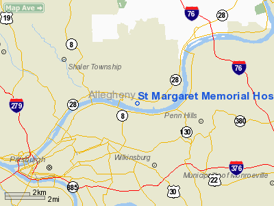
St Margaret Memorial Hospital Heliport |
Location & QuickFacts
| FAA Information Effective: | 2008-09-25 |
| Airport Identifier: | 46PA |
| Airport Status: | Operational |
| Longitude/Latitude: | 079-53-40.1820W/40-29-22.2460N
-79.894495/40.489513 (Estimated) |
| Elevation: | 761 ft / 231.95 m (Estimated) |
| Land: | 1 acres |
| From nearest city: | 1 nautical miles NE of Pittsburgh, PA |
| Location: | Allegheny County, PA |
| Magnetic Variation: | 08W (1990) |
Owner & Manager
| Ownership: | Privately owned |
| Owner: | St Margaret Memorial Hospital |
| Address: | 815 Freeport Rd
Pittsburgh, PA 15215 |
| Phone number: | 412-784-4210 |
| Manager: | Katherine Vidakovich |
| Address: | 815 Freeport Rd
Pittsburgh, PA 15215
ST MARGARET MEMORIAL HOSPITAL. |
| Phone number: | 412-784-4242 |
Airport Operations and Facilities
| Airport Use: | Private
MEDICAL USE. |
| Wind indicator: | Yes |
| Segmented Circle: | No |
| Control Tower: | No |
| Lighting Schedule: | DUSK-DAWN |
| Sectional chart: | Detroit |
| Region: | AEA - Eastern |
| Boundary ARTCC: | ZOB - Cleveland |
| Tie-in FSS: | AOO - Altoona |
| FSS on Airport: | No |
| FSS Toll Free: | 1-800-WX-BRIEF |
Runway Information
Helipad H1
| Dimension: | 65 x 65 ft / 19.8 x 19.8 m |
| Surface: | CONC, Good Condition |
| |
Runway H1 |
Runway |
| Traffic Pattern: | Left | Left |
|
Radio Navigation Aids
| ID |
Type |
Name |
Ch |
Freq |
Var |
Dist |
| MKP | NDB | Mc Keesport | | 287.00 | 07W | 9.6 nm |
| PNU | NDB | Washington County | | 255.00 | 08W | 24.1 nm |
| BHU | NDB | Benje | | 382.00 | 07W | 29.3 nm |
| VV | NDB | Camor | | 299.00 | 08W | 37.1 nm |
| INP | NDB | Indiana | | 242.00 | 08W | 38.8 nm |
| UCP | NDB | Castle | | 272.00 | 09W | 39.9 nm |
| HBD | NDB | Hubbard | | 408.00 | 08W | 49.3 nm |
| AGC | VOR/DME | Allegheny | 037X | 110.00 | 09W | 14.3 nm |
| HLG | VOR/DME | Wheeling | 059X | 112.20 | 07W | 33.8 nm |
| CIP | VOR/DME | Clarion | 076X | 112.90 | 06W | 44.2 nm |
| MMJ | VORTAC | Montour | 057X | 112.00 | 08W | 13.7 nm |
| EWC | VORTAC | Ellwood City | 105X | 115.80 | 08W | 24.8 nm |
| IHD | VORTAC | Indian Head | 019X | 108.20 | 06W | 39.6 nm |
| JST | VORTAC | Johnstown | 077X | 113.00 | 06W | 49.6 nm |
Remarks
- 020 DEG APCH/200 DEG DEPARTURE ROUTE; 110 DEG APCH/290 DEG DEPARTURE ROUTE (BENT APCH).
- PRVDD VFR OPNS ONLY; TREES TO W, S, E & PARKING LOT LIGHT POLES TO W & N ARE REMOVED; DUQUESENE LGT POLE NO 344630 IS OBSTN LGTD.
Images and information placed above are from
http://www.airport-data.com/airport/46PA/
We thank them for the data!
| General Info
|
| Country |
United States
|
| State |
PENNSYLVANIA
|
| FAA ID |
46PA
|
| Latitude |
40-29-22.246N
|
| Longitude |
079-53-40.182W
|
| Elevation |
761 feet
|
| Near City |
PITTSBURGH
|
We don't guarantee the information is fresh and accurate. The data may
be wrong or outdated.
For more up-to-date information please refer to other sources.
|
|


