 |
|
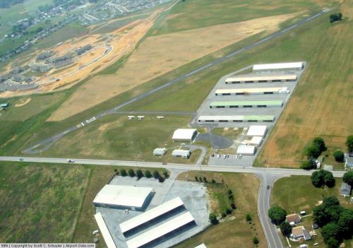 |
(Click on the photo to enlarge) |
Location & QuickFacts
| FAA Information Effective: | 2008-09-25 |
| Airport Identifier: | 58N |
| Airport Status: | Operational |
| Longitude/Latitude: | 076-34-38.8850W/40-17-15.3290N
-76.577468/40.287591 (Estimated) |
| Elevation: | 489 ft / 149.05 m (Surveyed) |
| Land: | 42 acres |
| From nearest city: | 2 nautical miles S of Palmyra, PA |
| Location: | Lebanon County, PA |
| Magnetic Variation: | 10W (1985) |
Owner & Manager
| Ownership: | Privately owned |
| Owner: | Wade/duane Reigle |
| Address: | 1805 S Forge Rd
Palmyra, PA 17078 |
| Phone number: | 717-838-5519 |
| Manager: | Wade E Reigle |
| Address: | 1805 S Forge Rd
Palmyra, PA 17078 |
| Phone number: | 717-838-5519 |
Airport Operations and Facilities
| Airport Use: | Open to public |
| Wind indicator: | Yes |
| Segmented Circle: | No |
| Control Tower: | No |
| Lighting Schedule: | RDO-CTL
ACTVT LIRL RY 13/31 & ROTG BCN - CTAF. |
| Beacon Color: | Clear-Green (lighted land airport) |
| Sectional chart: | New York |
| Region: | AEA - Eastern |
| Boundary ARTCC: | ZNY - New York |
| Tie-in FSS: | IPT - Williamsport |
| FSS on Airport: | No |
| FSS Toll Free: | 1-800-WX-BRIEF |
| NOTAMs Facility: | IPT (NOTAM-d service avaliable) |
Airport Communications
| CTAF: | 122.800 |
| Unicom: | 122.800 |
Airport Services
| Fuel available: | 100LLMOGAS |
| Airframe Repair: | MAJOR |
| Power Plant Repair: | MAJOR |
Runway Information
Runway 13/31
| Dimension: | 1950 x 40 ft / 594.4 x 12.2 m |
| Surface: | ASPH, Fair Condition |
| Weight Limit: | Single wheel: 12500 lbs. |
| Edge Lights: | Non-standard lighting system
RY 13 FIRST 110 FT UNLGTD; RY 31 FIRST 60 FT UNLGTD; 1780 FT OF RY LGTD. NSTD LIRL; LGTS LCTD 125 FT L & R OF CNTRLN. |
| |
Runway 13 |
Runway 31 |
| Traffic Pattern: | Left | Left |
| Markings: | Basic, Fair Condition | Basic, Fair Condition |
| Displaced threshold: | 0.00 ft | 300.00 ft
DSPLCD THR IDENTIFIED AT NIGHT BY ONE GREEN LGT EACH SIDE OF RY. |
| Obstruction: | 6 ft tree, 330.0 ft from runway, 126 ft right of centerline, 21:1 slope to clear | 54 ft tree, 1752.0 ft from runway, 201 ft right of centerline, 28:1 slope to clear
20:1 TO DSPLCD THR, +15 FT ROAD DIST 300 FT 71 FT R.
ROAD +15' 0-58' FROM THR. |
|
Radio Navigation Aids
| ID |
Type |
Name |
Ch |
Freq |
Var |
Dist |
| BZJ | NDB | Bellgrove | | 328.00 | 10W | 9.0 nm |
| EUD | NDB | York | | 254.00 | 11W | 26.0 nm |
| LQX | NDB | Carbon | | 339.00 | 12W | 48.9 nm |
| HXM | NDB | Humbolt | | 366.00 | 10W | 49.8 nm |
| HZL | VOR | Hazleton | | 109.40 | 09W | 46.2 nm |
| ETX | VOR/DME | East Texas | 039X | 110.20 | 09W | 44.5 nm |
| RAV | VORTAC | Ravine | 093X | 114.60 | 11W | 16.0 nm |
| LRP | VORTAC | Lancaster | 120X | 117.30 | 09W | 16.6 nm |
| HAR | VORTAC | Harrisburg | 072X | 112.50 | 10W | 22.6 nm |
| SEG | VORTAC | Selinsgrove | 041X | 110.40 | 08W | 33.3 nm |
| MIP | VORTAC | Milton | 029X | 109.20 | 09W | 44.4 nm |
| PTW | VORTAC | Pottstown | 112X | 116.50 | 09W | 46.8 nm |
| MXE | VORTAC | Modena | 079X | 113.20 | 09W | 47.2 nm |
| MDT | VOT | Harrisburg International | | 110.00 | | 10.1 nm |
Remarks
- FOR PICKUP CLNC TF 800-932-0712.
Images and information placed above are from
http://www.airport-data.com/airport/58N/
We thank them for the data!
| General Info
|
| Country |
United States
|
| State |
PENNSYLVANIA
|
| FAA ID |
58N
|
| Latitude |
40-17-15.329N
|
| Longitude |
076-34-38.885W
|
| Elevation |
489 feet
|
| Near City |
PALMYRA
|
We don't guarantee the information is fresh and accurate. The data may
be wrong or outdated.
For more up-to-date information please refer to other sources.
|
|


