 |
|
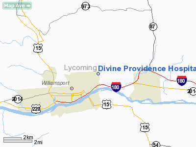
Divine Providence Hospital Heliport |
Location & QuickFacts
| FAA Information Effective: | 2008-09-25 |
| Airport Identifier: | 3PS6 |
| Airport Status: | Operational |
| Longitude/Latitude: | 076-58-59.8800W/41-15-36.2820N
-76.983300/41.260078 (Estimated) |
| Elevation: | 581 ft / 177.09 m (Estimated) |
| Land: | 0 acres |
| From nearest city: | 3 nautical miles SS of Williamsport, PA |
| Location: | Lycoming County, PA |
| Magnetic Variation: | 11W (1985) |
Owner & Manager
| Ownership: | Privately owned |
| Owner: | Divine Providence Hospital |
| Address: | 1100 Grampian Boulevard
Williamsport, PA 17701 |
| Phone number: | 717-326-8181 |
| Manager: | William F. Vanaskie |
| Address: | 1100 Grampian Boulevard
Williamsport, PA 17701 |
| Phone number: | 717-326-8005 |
Airport Operations and Facilities
| Airport Use: | Private
MEDICAL USE. |
| Wind indicator: | Yes |
| Segmented Circle: | No |
| Control Tower: | No |
| Lighting Schedule: | PHONE REQ
FOR PERIMETER LGTS, CALL 717-326-8111. |
| Landing fee charge: | No |
| Sectional chart: | New York |
| Region: | AEA - Eastern |
| Boundary ARTCC: | ZNY - New York |
| Tie-in FSS: | IPT - Williamsport |
| FSS on Airport: | No |
| FSS Toll Free: | 1-800-WX-BRIEF |
Runway Information
Helipad H1
| Dimension: | 65 x 65 ft / 19.8 x 19.8 m |
| Surface: | CONC, Good Condition |
| |
Runway H1 |
Runway |
| Traffic Pattern: | Left | Left |
|
Radio Navigation Aids
| ID |
Type |
Name |
Ch |
Freq |
Var |
Dist |
| PIX | NDB | Picture Rocks | | 344.00 | 09W | 12.4 nm |
| HXM | NDB | Humbolt | | 366.00 | 10W | 47.5 nm |
| HZL | VOR | Hazleton | | 109.40 | 09W | 42.4 nm |
| FQM | VOR/DME | Williamsport | 091X | 114.40 | 09W | 10.5 nm |
| SFK | VOR/DME | Stonyfork | 023X | 108.60 | 08W | 32.7 nm |
| MIP | VORTAC | Milton | 029X | 109.20 | 09W | 20.2 nm |
| SEG | VORTAC | Selinsgrove | 041X | 110.40 | 08W | 28.6 nm |
| RAV | VORTAC | Ravine | 093X | 114.60 | 11W | 45.9 nm |
| SLT | VORTAC | Slate Run | 086X | 113.90 | 08W | 47.0 nm |
Remarks
- CONTACT WILLIAMSPORT ATCT REGARDING ALTITUDES & ROUTES TO BE USED, PILOTS ARE BRIEFED ACCORDINGLY.
Images and information placed above are from
http://www.airport-data.com/airport/3PS6/
We thank them for the data!
| General Info
|
| Country |
United States
|
| State |
PENNSYLVANIA
|
| FAA ID |
3PS6
|
| Latitude |
41-15-36.282N
|
| Longitude |
076-58-59.880W
|
| Elevation |
581 feet
|
| Near City |
WILLIAMSPORT
|
We don't guarantee the information is fresh and accurate. The data may
be wrong or outdated.
For more up-to-date information please refer to other sources.
|
|


