|
|
Albert - Picardie Airport
Aéroport d'Albert - Picardie |
 |
| IATA: none – ICAO: LFAQ
Location of airport in France
|
| Summary |
| Airport type |
Public |
| Operator |
Société d’Exploitation Aéroport Albert Picardie (SEAAP) |
| Serves |
Albert, Somme, France |
| Location |
Bray-sur-Somme |
| Elevation AMSL |
363 ft / 111 m |
| Coordinates |
49°58′12″N 002°41′33″E / 49.97°N 2.6925°E / 49.97; 2.6925 |
| Website |
AeroportAlbertPicardie.fr |
| Runways |
| Direction |
Length |
Surface |
| m |
ft |
| 09/27 |
2,200 |
7,218 |
Macadam |
| 09R/27L |
1,000 |
3,281 |
Grass |
| Sources: French AIP, UAF |
Albert - Picardie Airport (French: Aéroport d'Albert - Picardie) (ICAO: LFAQ), sometimes referred to as Albert - Picardy Airport, is an airport serving Albert, a commune of the Somme department in the Picardy (Picardie) region of northern France. The airport is located 4 km (2 mi) southeast of Albert, in Bray-sur-Somme.
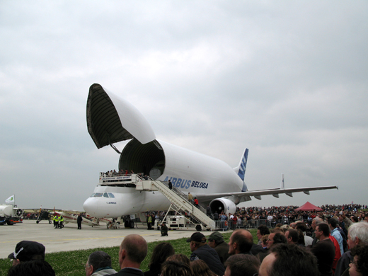 | |
Airbus Beluga at Albert-Picardie (2008) |
It is primarily used for the transportation of Airbus aircraft parts from the nearby Méaulte Airbus Factory. The airport's runway is large enough to accommodate Airbus' Beluga aircraft, a large cargo aircraft used to courier parts used in the construction of its own commercial jets.
The airport is also home to a flying club, who have a number of light aircraft based at the airfield.
The British low-cost carrier Jet2.com announced and then canceled a planned twice-weekly service to the Somme using this airport, flights were to start in April 2009.
Facilities
The airport resides at an elevation of 364 feet (111 m) above mean sea level. It has one paved runway designated 09/27 which measures 2,200 by 45 metres (7,218 × 148 ft). It also has a parallel unpaved runway with a grass surface measuring 1,000 by 80 metres (3,281 × 262 ft).
The above content comes from Wikipedia and is published under free licenses – click here to read more.
Location & QuickFacts
| FAA Information Effective: | 2008-09-25 |
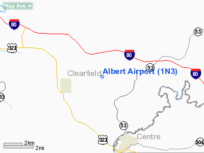
| Airport Identifier: | 1N3 |
| Airport Status: | Operational |
| Longitude/Latitude: | 078-14-34.3000W/40-58-17.5600N
-78.242861/40.971544 (Estimated) |
| Elevation: | 1784 ft / 543.76 m (Estimated) |
| Land: | 150 acres |
| From nearest city: | 5 nautical miles N of Philipsburg, PA |
| Location: | Clearfield County, PA |
| Magnetic Variation: | 09W (1985) |
Owner & Manager
| Ownership: | Privately owned |
| Owner: | Frank W Albert Estate |
| Address: | Box 204
Morrisdale, PA 16858 |
| Phone number: | 814-345-5920 |
| Manager: | Anna Pezzulla |
| Address: | Box 204
Morrisdale, PA 16858 |
| Phone number: | 814-345-5920 |
Airport Operations and Facilities
| Airport Use: | Open to public |
| Wind indicator: | Yes |
| Segmented Circle: | No |
| Control Tower: | No |
| Landing fee charge: | No |
| Sectional chart: | Detroit |
| Region: | AEA - Eastern |
| Boundary ARTCC: | ZOB - Cleveland |
| Tie-in FSS: | AOO - Altoona |
| FSS on Airport: | No |
| FSS Toll Free: | 1-800-WX-BRIEF |
| NOTAMs Facility: | AOO (NOTAM-d service avaliable) |
Airport Communications
Airport Services
| Airframe Repair: | NONE |
| Power Plant Repair: | NONE |
| Bottled Oxygen: | NONE |
| Bulk Oxygen: | NONE |
Runway Information
Runway 11/29
| Dimension: | 3350 x 125 ft / 1021.1 x 38.1 m |
| Surface: | GRVL, Fair Condition |
| |
Runway 11 |
Runway 29 |
| Traffic Pattern: | Left | Left |
| Markings: | Nonstandard, Fair Condition
RY 11/29 EDGES MKD WITH YELLOW BARRELS. | Nonstandard, Fair Condition
RY EDGES MKD WITH YELLOW BARRELS. |
| Displaced threshold: | 0.00 ft
RY DSPLCD THLD MKD WITH RED BARRELS. | 205.00 ft
RY DSPLCD THLD MKD WITH RED BARRELS. |
| Obstruction: | 42 ft trees, 178.0 ft from runway, 127 ft right of centerline, 4:1 slope to clear
RY 11 APCH RATIO 21:1 TO DSPLCD THLD. | 8 ft sign, 12.0 ft from runway, 101 ft left of centerline, 1:1 slope to clear
APCH SLOPE 27:1 FROM DSPLCD THLD TO ROAD. |
|
Radio Navigation Aids
| ID |
Type |
Name |
Ch |
Freq |
Var |
Dist |
| RV | NDB | Stroh | | 407.00 | 10W | 32.1 nm |
| INP | NDB | Indiana | | 242.00 | 08W | 42.7 nm |
| AOO | VOR | Altoona | | 108.80 | 07W | 38.9 nm |
| REC | VOR/DME | Revloc | 043X | 110.60 | 09W | 34.3 nm |
| PSB | VORTAC | Philipsburg | 102X | 115.50 | 10W | 11.8 nm |
| TON | VORTAC | Tyrone | 096X | 114.90 | 07W | 14.8 nm |
| ETG | VORTAC | Keating | 107X | 116.00 | 10W | 15.3 nm |
| SLT | VORTAC | Slate Run | 086X | 113.90 | 08W | 34.8 nm |
| JST | VORTAC | Johnstown | 077X | 113.00 | 06W | 47.7 nm |
Remarks
- ULTRALIGHT OPNS ON & INVOF ARPT.
- BIRDS; DEER & GROUND HOGS ON & INVOF ARPT.
- VFR ONLY
Images and information placed above are from
http://www.airport-data.com/airport/1N3/
We thank them for the data!
| General Info
|
| Country |
United States
|
| State |
PENNSYLVANIA
|
| FAA ID |
1N3
|
| Latitude |
40-58-17.560N
|
| Longitude |
078-14-34.300W
|
| Elevation |
1784 feet
|
| Near City |
PHILIPSBURG
|
We don't guarantee the information is fresh and accurate. The data may
be wrong or outdated.
For more up-to-date information please refer to other sources.
|
|