 |
|
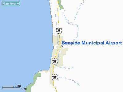
| Seaside Municipal Airport |
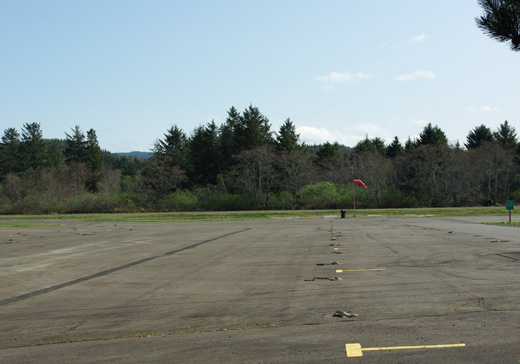 |
| Windsock and plane parking |
| IATA: none – ICAO: none – FAA LID: 56S |
| Summary |
| Airport type |
Public |
| Operator |
City of Seaside |
| Location |
Seaside, Oregon |
| Elevation AMSL |
6 ft / 2 m |
| Coordinates |
46°00′59.3890″N 123°54′19.5000″W / 46.01649694°N 123.905417°W / 46.01649694; -123.905417Coordinates: 46°00′59.3890″N 123°54′19.5000″W / 46.01649694°N 123.905417°W / 46.01649694; -123.905417 |
| Runways |
| Direction |
Length |
Surface |
| ft |
m |
| 16/34 |
2360 |
719 |
Asphalt |
Seaside Municipal Airport (FAA LID: 56S), is a public airport located one mile (1.6 km) southwest of Seaside in Clatsop County, Oregon, USA.
The above content comes from Wikipedia and is published under free licenses – click here to read more.
Location & QuickFacts
| FAA Information Effective: | 2008-09-25 |
| Airport Identifier: | 56S |
| Airport Status: | Operational |
| Longitude/Latitude: | 123-54-27.5670W/46-00-53.9850N
-123.907657/46.014996 (Estimated) |
| Elevation: | 12 ft / 3.66 m (Estimated) |
| Land: | 32 acres |
| From nearest city: | 1 nautical miles NE of Seaside, OR |
| Location: | Clatsop County, OR |
| Magnetic Variation: | 20E (1985) |
Owner & Manager
| Ownership: | Publicly owned |
| Owner: | City Of Seaside |
| Address: | 989 Broadway
Seaside, OR 97138 |
| Phone number: | 503-738-5511 |
| Manager: | Neal Wallace |
| Address: | 1387 Ave U
Seaside, OR 97138 |
| Phone number: | 503-738-5112 |
Airport Operations and Facilities
| Airport Use: | Open to public |
| Wind indicator: | Yes |
| Segmented Circle: | Yes |
| Control Tower: | No |
| Lighting Schedule: | DUSK-DAWN |
| Beacon Color: | Clear-Green (lighted land airport) |
| Landing fee charge: | No |
| Sectional chart: | Seattle |
| Region: | ANM - Northwest Mountain |
| Traffic Pattern Alt: | 1000 ft |
| Boundary ARTCC: | ZSE - Seattle |
| Tie-in FSS: | MMV - Mc Minnville |
| FSS on Airport: | No |
| FSS Toll Free: | 1-800-WX-BRIEF |
| NOTAMs Facility: | MMV (NOTAM-d service avaliable) |
| Federal Agreements: | NGY |
Airport Communications
Airport Services
| Airframe Repair: | NONE |
| Power Plant Repair: | NONE |
| Bottled Oxygen: | NONE |
| Bulk Oxygen: | NONE |
Runway Information
Runway 16/34
| Dimension: | 2211 x 50 ft / 673.9 x 15.2 m |
| Surface: | ASPH, Good Condition |
| Weight Limit: | Single wheel: 12000 lbs. |
| Edge Lights: | Low |
| |
Runway 16 |
Runway 34 |
| Longitude: | 123-54-27.5970W | 123-54-27.5370W |
| Latitude: | 46-01-04.8970N | 46-00-43.0730N |
| Elevation: | 12.00 ft | 10.00 ft |
| Traffic Pattern: | Left | Left |
| Markings: | Basic, Good Condition | Basic, Good Condition |
| Displaced threshold: | 155.00 ft | 0.00 ft |
| Obstruction: | 50 ft trees, 921.0 ft from runway, 120 ft left of centerline, 14:1 slope to clear
RY 16, 30 FT TREES DIST 40 FT, 90 FT L, APCH SLOPE 6:1 BASED ON DSPLCD THLD.
RWY 16 +35' TREES 0' FM THR 120' LEFT. | 36 ft tree, 431.0 ft from runway, 150 ft right of centerline, 6:1 slope to clear
RWY 34 +16 FT TREES 0 FT FM THLD 120 FT R. |
|
Radio Navigation Aids
| ID |
Type |
Name |
Ch |
Freq |
Var |
Dist |
| AST | FAN MARKER | Fort Stevens | | | 22E | 11.9 nm |
| PEN | NDB | Karpen | | 201.00 | 20E | 15.3 nm |
| LSO | NDB | Kelso | | 256.00 | 21E | 42.3 nm |
| PND | NDB | Banks | | 356.00 | 21E | 42.9 nm |
| AST | VOR/DME | Astoria | 087X | 114.00 | 19E | 8.9 nm |
| HIO | VOT | Portland-hillsboro | | 115.20 | | 49.3 nm |
Remarks
- BIRDS AND ELK ON & INVOF RY.
Images and information placed above are from
http://www.airport-data.com/airport/56S/
We thank them for the data!
| General Info
|
| Country |
United States
|
| State |
OREGON
|
| FAA ID |
56S
|
| Latitude |
46-00-59.389N
|
| Longitude |
123-54-19.500W
|
| Elevation |
6 feet
|
| Near City |
SEASIDE
|
We don't guarantee the information is fresh and accurate. The data may
be wrong or outdated.
For more up-to-date information please refer to other sources.
|
|


