|
|
Scappoose Industrial Airpark Airport |
| Scappoose Industrial Airpark |
 |
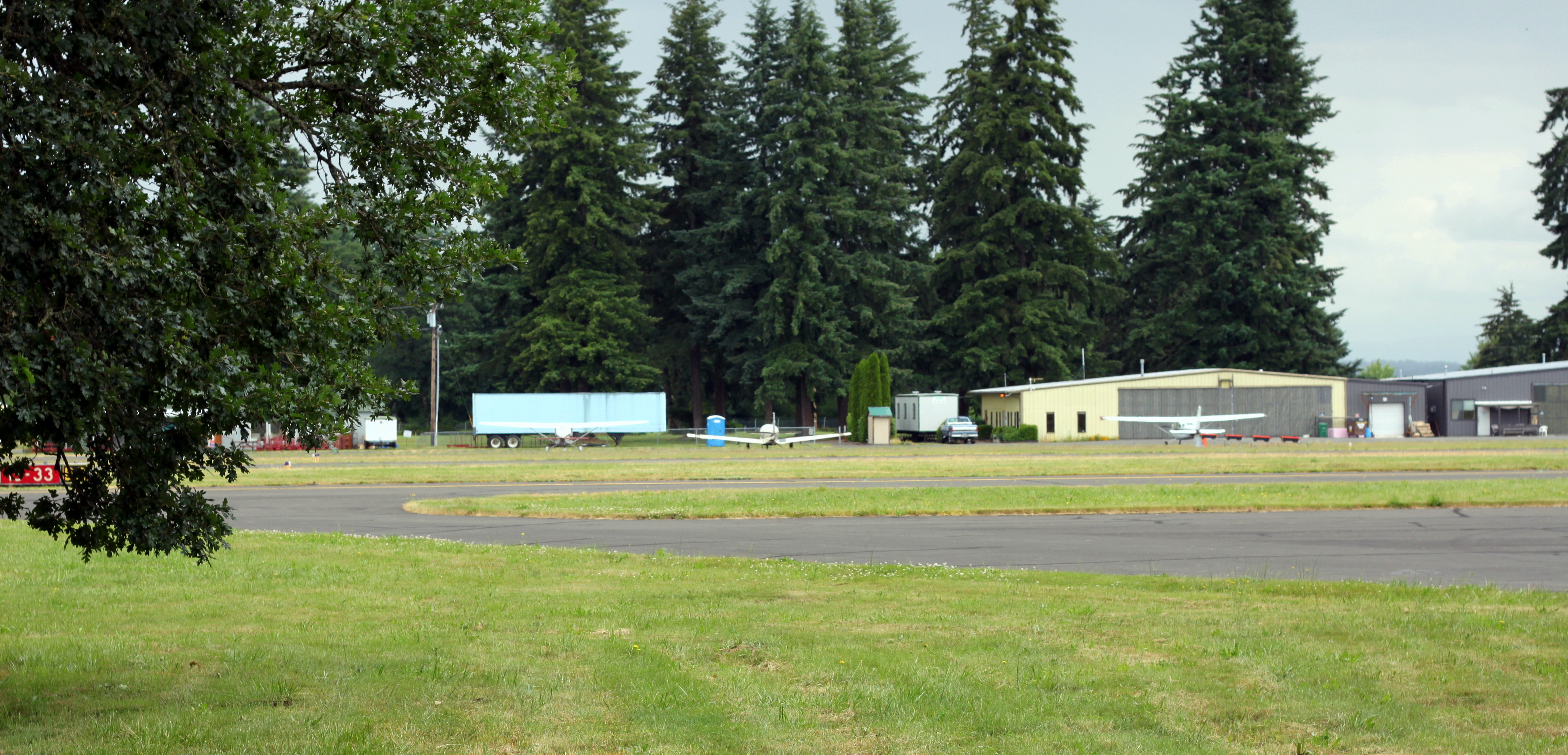
| Hangars, planes, and runway |
| IATA: none – ICAO: KSPB – FAA LID: SPB |
| Summary |
| Airport type |
Public |
| Owner/Operator |
Port of St. Helens |
| Serves |
Scappoose, Oregon |
| Elevation AMSL |
58 ft / 18 m |
| Coordinates |
45°46′16″N 122°51′43″W / 45.77111°N 122.86194°W / 45.77111; -122.86194 |
| Website |
ScappooseAirport.com |
| Runways |
| Direction |
Length |
Surface |
| ft |
m |
| 15/33 |
5,100 |
1,554 |
Asphalt |
| Statistics (2009) |
| Aircraft operations |
75,500 |
| Based aircraft |
57 |
| Source: Federal Aviation Administration |
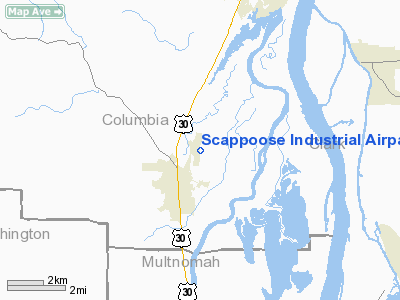
Scappoose Industrial Airpark (ICAO: KSPB, FAA LID: SPB, formerly 1S4) is a public use airport located one nautical mile (1.85 km) northeast of the central business district of Scappoose, in Columbia County, Oregon, United States. It is owned and operated by the Port of St. Helens, an Oregon port district and municipal corporation, on behalf of district residents. According to the FAA's National Plan of Integrated Airport Systems for 2009–2013, it is categorized as a general aviation airport.
Although many U.S. airports use the same three-letter location identifier for the FAA and IATA, this airport is assigned SPB by the FAA but has no designation from the IATA (which assigned SPB to Charlotte Amalie Harbor Seaplane Base in Charlotte Amalie, Saint Thomas, U.S. Virgin Islands).
Facilities and aircraft
Scappoose Industrial Airpark covers an area of 196 acres (79 ha) at an elevation of 58 feet (18 m) above mean sea level. It has one runway designated 15/33 with an asphalt surface measuring 5,100 by 100 feet (1,554 x 30 m).
For the 12-month period ending April 29, 2009, the airport had 75,500 aircraft operations, an average of 206 per day: 93% general aviation, 7% air taxi, and <1% military. At that time there were 57 aircraft based at this airport: 75% single-engine, 2% multi-engine, 2% helicopter and 21% ultralight.
The above content comes from Wikipedia and is published under free licenses – click here to read more.
Location & QuickFacts
| FAA Information Effective: | 2008-09-25 |
| Airport Identifier: | SPB |
| Airport Status: | Operational |
| Longitude/Latitude: | 122-51-42.6000W/45-46-15.7000N
-122.861833/45.771028 (Estimated) |
| Elevation: | 58 ft / 17.68 m (Surveyed) |
| Land: | 196 acres |
| From nearest city: | 1 nautical miles NE of Scappoose, OR |
| Location: | Columbia County, OR |
| Magnetic Variation: | 20E (1980) |
Owner & Manager
| Ownership: | Publicly owned |
| Owner: | Port Of St Helens |
| Address: | Po Box 598
St Helens, OR 97051 |
| Phone number: | 503-397-2888 |
| Manager: | Kim Shade-houser |
| Address: | Po Box 598
St Helens, OR 97051 |
| Phone number: | 503-397-2888 |
Airport Operations and Facilities
| Airport Use: | Open to public |
| Wind indicator: | Yes |
| Segmented Circle: | Yes |
| Control Tower: | No |
| Lighting Schedule: | DUSK-DAWN |
| Beacon Color: | Clear-Green (lighted land airport) |
| Landing fee charge: | No |
| Sectional chart: | Seattle |
| Region: | ANM - Northwest Mountain |
| Boundary ARTCC: | ZSE - Seattle |
| Tie-in FSS: | MMV - Mc Minnville |
| FSS on Airport: | No |
| FSS Toll Free: | 1-800-WX-BRIEF |
| NOTAMs Facility: | SPB (NOTAM-d service avaliable) |
| Federal Agreements: | NGY3 |
Airport Communications
| CTAF: | 122.800 |
| Unicom: | 122.800 |
Airport Services
| Fuel available: | 100LLA |
| Airframe Repair: | MAJOR |
| Power Plant Repair: | MAJOR |
| Bottled Oxygen: | NONE |
| Bulk Oxygen: | NONE |
Runway Information
Runway 15/33
| Dimension: | 5100 x 100 ft / 1554.5 x 30.5 m |
| Surface: | ASPH, Good Condition |
| Surface Treatment: | Rubberized Friction Seal Coat |
| Weight Limit: | Single wheel: 30000 lbs.
Dual wheel: 50000 lbs.
Dual tandem wheel: 90000 lbs. |
| Edge Lights: | Medium |
| |
Runway 15 |
Runway 33 |
| Longitude: | 122-51-49.6531W | 122-51-35.4943W |
| Latitude: | 45-46-40.4083N | 45-45-51.0442N |
| Elevation: | 58.00 ft | 30.00 ft |
| Alignment: | 127 | 127 |
| ILS Type: | LOC/DME
| |
| Traffic Pattern: | Left | Right |
| Markings: | Non-precision instrument, Good Condition | Non-precision instrument, Good Condition |
| Crossing Height: | 40.00 ft | 40.00 ft |
| VASI: | 4-light PAPI on left side
PAPI RYS 15 & 33 OTS INDEFLY. | 4-light PAPI on left side |
| Visual Glide Angle: | 3.00° | 3.00° |
| Runway End Identifier: | Yes | |
| Obstruction: | 80 ft tree, 1500.0 ft from runway, 450 ft left of centerline, 16:1 slope to clear | , 50:1 slope to clear |
|
Radio Navigation Aids
| ID |
Type |
Name |
Ch |
Freq |
Var |
Dist |
| PND | NDB | Banks | | 356.00 | 21E | 11.5 nm |
| LBH | NDB | Laker | | 332.00 | 20E | 21.7 nm |
| LSO | NDB | Kelso | | 256.00 | 21E | 23.2 nm |
| PEN | NDB | Karpen | | 201.00 | 20E | 37.5 nm |
| TDO | NDB | Toledo | | 219.00 | 20E | 42.4 nm |
| CBU | TACAN | Columbia | 029X | | 20E | 15.2 nm |
| PDX | VOR/DME | Portland | 055X | 111.80 | 20E | 15.1 nm |
| UBG | VOR/DME | Newberg | 121X | 117.40 | 21E | 25.6 nm |
| AST | VOR/DME | Astoria | 087X | 114.00 | 19E | 48.6 nm |
| BTG | VORTAC | Battle Ground | 113X | 116.60 | 21E | 11.4 nm |
| HIO | VOT | Portland-hillsboro | | 115.20 | | 14.3 nm |
| PDX | VOT | Portland Intl | | 111.00 | | 15.1 nm |
Remarks
- BLUE LGTS & CNTRLN REFLECTORS AT ALL TWY EXITS FM RY.
- EXTENSIVE ULTRALIGHT ACTIVITY ON WEST SIDE PARALLEL TWY.
Images and information placed above are from
http://www.airport-data.com/airport/SPB/
We thank them for the data!
| General Info
|
| Country |
United States
|
| State |
OREGON
|
| FAA ID |
SPB
|
| Latitude |
45-46-21.016N
|
| Longitude |
122-51-44.500W
|
| Elevation |
58 feet
|
| Near City |
SCAPPOOSE
|
We don't guarantee the information is fresh and accurate. The data may
be wrong or outdated.
For more up-to-date information please refer to other sources.
|
|