 |
|
Santiam Junction State Airport |
| Santiam Junction State Airport |
| IATA: none – ICAO: none – FAA LID: 8S3 |
| Summary |
| Airport type |
Public |
| Operator |
Oregon Department of Aviation |
| Location |
Santiam Junction, Oregon |
| Elevation AMSL |
3780 ft / 1152 m |
| Coordinates |
44°26′04.4000″N 121°56′32.2000″W / 44.434556°N 121.942278°W / 44.434556; -121.942278Coordinates: 44°26′04.4000″N 121°56′32.2000″W / 44.434556°N 121.942278°W / 44.434556; -121.942278 |
| Runways |
| Direction |
Length |
Surface |
| ft |
m |
| 6/24 |
2800 |
853 |
Gravel |
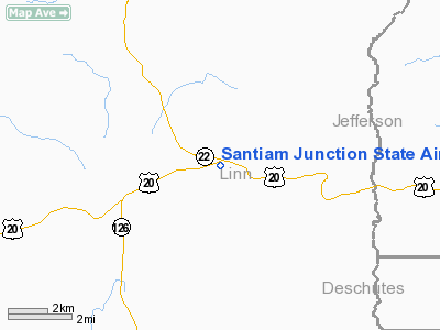
Santiam Junction State Airport (ICAO: 8S3), is a public airport located adjacent to Santiam Junction in Linn County, Oregon, USA. Santiam Junction is the intersection of U.S. Route 20 and Oregon Route 22. The Oregon Department of Transportation has a maintenance facility located on the north side of the field.
The above content comes from Wikipedia and is published under free licenses – click here to read more.
Location & QuickFacts
| FAA Information Effective: | 2008-09-25 |
| Airport Identifier: | 8S3 |
| Airport Status: | Operational |
| Longitude/Latitude: | 121-56-32.2000W/44-26-04.4000N
-121.942278/44.434556 (Estimated) |
| Elevation: | 3780 ft / 1152.14 m (Estimated) |
| Land: | 40 acres |
| From nearest city: | 0 nautical miles S of Santiam Junction, OR |
| Location: | Linn County, OR |
| Magnetic Variation: | 19E (1985) |
Owner & Manager
| Ownership: | Publicly owned |
| Owner: | Oregon Dept Of Aviation |
| Address: | 3040 25th St Se
Salem, OR 97302 |
| Phone number: | 503-378-4880 |
| Manager: | State Airports Mgr |
| Address: | 3040 25th St Se
Salem, OR 97302 |
| Phone number: | 503-378-4880 |
Airport Operations and Facilities
| Airport Use: | Open to public |
| Wind indicator: | Yes |
| Segmented Circle: | Yes |
| Control Tower: | No |
| Landing fee charge: | No |
| Sectional chart: | Klamath Falls |
| Region: | ANM - Northwest Mountain |
| Traffic Pattern Alt: | 1000 ft |
| Boundary ARTCC: | ZSE - Seattle |
| Tie-in FSS: | MMV - Mc Minnville |
| FSS on Airport: | No |
| FSS Toll Free: | 1-800-WX-BRIEF |
| NOTAMs Facility: | MMV (NOTAM-d service avaliable) |
Airport Communications
Airport Services
| Airframe Repair: | NONE |
| Power Plant Repair: | NONE |
| Bottled Oxygen: | NONE |
| Bulk Oxygen: | NONE |
Runway Information
Runway 06/24
| Dimension: | 2800 x 150 ft / 853.4 x 45.7 m |
| Surface: | GRVL, Fair Condition
VOLCANIC CINDERS. |
| |
Runway 06 |
Runway 24 |
| Traffic Pattern: | Left | Left |
| Obstruction: | 24 ft trees, 165.0 ft from runway, 100 ft right of centerline, 7:1 slope to clear | 190 ft trees, 450.0 ft from runway, 2:1 slope to clear |
|
Radio Navigation Aids
| ID |
Type |
Name |
Ch |
Freq |
Var |
Dist |
| RD | NDB | Bodey | | 411.00 | 18E | 40.4 nm |
| DSD | VORTAC | Deschutes | 123X | 117.60 | 18E | 29.6 nm |
Remarks
- ARPT SURROUNDED BY TREES AND HIGH TERRAIN.
-
- OWNER ADVISES CONTACT WITH DEPT OF AVIATION (503-378-4880) PRIOR TO USE.
- ESTABD PRIOR TO 1959.
Images and information placed above are from
http://www.airport-data.com/airport/8S3/
We thank them for the data!
| General Info
|
| Country |
United States
|
| State |
OREGON
|
| FAA ID |
8S3
|
| Latitude |
44-26-04.400N
|
| Longitude |
121-56-32.200W
|
| Elevation |
3780 feet
|
| Near City |
SANTIAM JUNCTION
|
We don't guarantee the information is fresh and accurate. The data may
be wrong or outdated.
For more up-to-date information please refer to other sources.
|
|


