 |
|
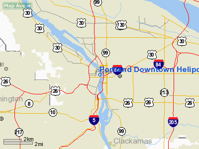
Portland Downtown Heliport |
| Portland Downtown Heliport |
| IATA: none – ICAO: none – FAA LID: 61J |
| Summary |
| Airport type |
Public |
| Operator |
City of Portland |
| Location |
Portland, Oregon |
| Elevation AMSL |
78 ft / 23.5 m |
| Coordinates |
45°31′31.0000″N 122°40′15.3440″W / 45.52528°N 122.67092889°W / 45.52528; -122.67092889Coordinates: 45°31′31.0000″N 122°40′15.3440″W / 45.52528°N 122.67092889°W / 45.52528; -122.67092889 |
| Helipads |
| Number |
Length |
Surface |
| ft |
m |
| H1 |
80 |
24 |
concrete |
Portland Downtown Heliport (FAA LID: 61J), is a public heliport located in the Old Town Chinatown neighborhood in the Northwest section of the city of Portland, Multnomah County, Oregon, USA. It occupies the roof of a 1989 parking garage located at the intersection of NW Naito Parkway and NW Davis Street, not far from the Steel Bridge over the Willamette River.
The Downtown Heliport currently has the distinction of being Oregon's only public use heliport.
The above content comes from Wikipedia and is published under free licenses – click here to read more.
Location & QuickFacts
| FAA Information Effective: | 2008-09-25 |
| Airport Identifier: | 61J |
| Airport Status: | Operational |
| Longitude/Latitude: | 122-40-15.3440W/45-31-31.0000N
-122.670929/45.525278 (Estimated) |
| Elevation: | 78 ft / 23.77 m (Surveyed) |
| Land: | 1 acres |
| From nearest city: | 0 nautical miles N of Portland, OR |
| Location: | Multnomah County, OR |
| Magnetic Variation: | 19E (1985) |
Owner & Manager
| Ownership: | Publicly owned |
| Owner: | City Of Portland,gen Svcs |
| Address: | 1120 Sw 5 Th Ave
Portland, OR 97204 |
| Phone number: | 503-796-5252 |
| Manager: | John Helm |
| Address: | 111 Sw 5th Ave Suite 3500
Portland, OR 97204
N. W. ROTORCRAFT ASSN. |
| Phone number: | 503-286-0927 |
Airport Operations and Facilities
| Airport Use: | Open to public |
| Wind indicator: | Yes |
| Segmented Circle: | No |
| Control Tower: | No |
| Lighting Schedule: | DUSK-DAWN
FOR HELIPORT PLASI WHEN APPROACHING FLT APCH & TKOF 020 - ACTVT CTAF 3 TIMES; WHEN APPROACHING FLIGHT APCH & TKOF 025 - ACTVT CTAF 5 TIMES; WHEN APPROACHING FLT APCH & TKOF 030 - ACTVT CTAF 7 TIMES. |
| Beacon Color: | Clear-Green-Yellow (heliport) |
| Landing fee charge: | Yes |
| Sectional chart: | Seattle |
| Region: | ANM - Northwest Mountain |
| Boundary ARTCC: | ZSE - Seattle |
| Tie-in FSS: | MMV - Mc Minnville |
| FSS Toll Free: | 1-800-WX-BRIEF |
| NOTAMs Facility: | MMV (NOTAM-d service avaliable) |
| Federal Agreements: | N |
Airport Communications
| CTAF: | 123.075 |
| Unicom: | 123.075 |
Airport Services
| Airframe Repair: | NONE |
| Power Plant Repair: | NONE |
Runway Information
Helipad H1
| Dimension: | 80 x 80 ft / 24.4 x 24.4 m |
| Surface: | CONC, Good Condition |
| Weight Limit: | Single wheel: 25000 lbs. |
| |
Runway H1 |
Runway |
| Traffic Pattern: | Left | Left |
| Markings: | Basic, Poor Condition
MARKINGS ARE VERY FADED AND CHIPED. | ,
MARKINGS ARE VERY FADED AND CHIPED. |
|
Radio Navigation Aids
| ID |
Type |
Name |
Ch |
Freq |
Var |
Dist |
| LBH | NDB | Laker | | 332.00 | 20E | 8.8 nm |
| PND | NDB | Banks | | 356.00 | 21E | 17.0 nm |
| LSO | NDB | Kelso | | 256.00 | 21E | 39.2 nm |
| CBU | TACAN | Columbia | 029X | | 20E | 4.6 nm |
| PDX | VOR/DME | Portland | 055X | 111.80 | 20E | 4.9 nm |
| UBG | VOR/DME | Newberg | 121X | 117.40 | 21E | 16.6 nm |
| BTG | VORTAC | Battle Ground | 113X | 116.60 | 21E | 13.8 nm |
| PDX | VOT | Portland Intl | | 111.00 | | 5.3 nm |
| HIO | VOT | Portland-hillsboro | | 115.20 | | 11.7 nm |
Remarks
- PARKING FEE IF MORE THAN 30 MINUTES.
- +199 FT RADIO TOWER (LIGHTED) 4950 FT E OF HELIPORT IN FLT APCH & TKOF 025.
Images and information placed above are from
http://www.airport-data.com/airport/61J/
We thank them for the data!
| General Info
|
| Country |
United States
|
| State |
OREGON
|
| FAA ID |
61J
|
| Latitude |
45-31-31.000N
|
| Longitude |
122-40-15.344W
|
| Elevation |
78 feet
|
| Near City |
PORTLAND
|
We don't guarantee the information is fresh and accurate. The data may
be wrong or outdated.
For more up-to-date information please refer to other sources.
|
|


