|
 |
|
||||
|
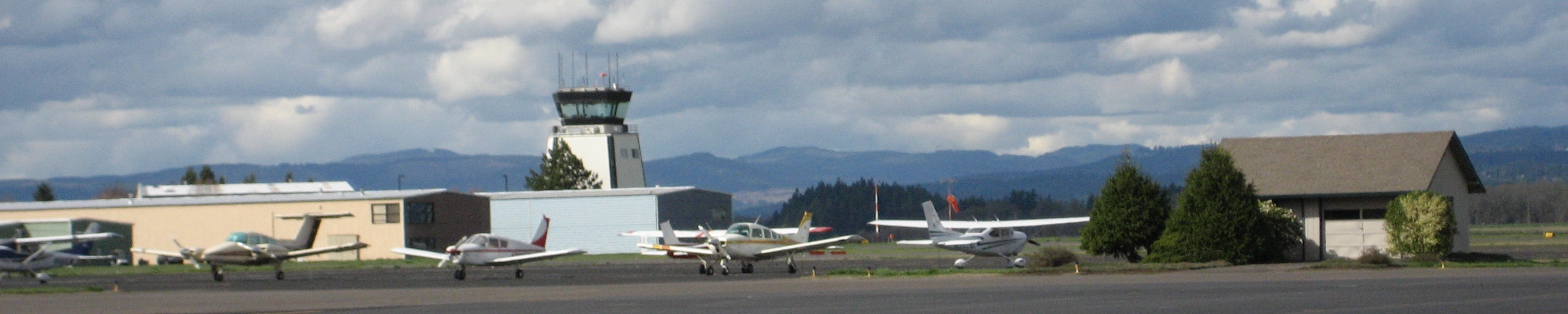
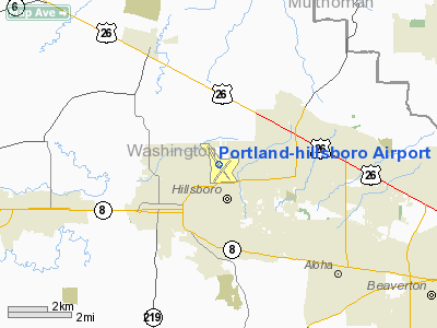
Hillsboro Airport (IATA: HIO, ICAO: KHIO), also known as Portland-Hillsboro Airport, is the name of a corporate, general aviation and flight-training airport serving the city of Hillsboro, in Washington County, Oregon, USA. It is one of four airports in the Portland, Oregon, metropolitan area owned and operated by the Port of Portland. Established in 1928, it is Oregon's second busiest airport at over 200,000 operations annually. Located in the north-central area of Hillsboro, and west of Portland, it hosts the annual Oregon International Airshow. The airport includes an Federal Aviation Administration control tower, two paved runways, hangars, fueling facilities, and a small passenger terminal. Hillsboro Airport is also a port of entry, with a single person U.S. Customs and Border Protection office. HistoryHillsboro airport goes back to as early as 1928. Dr. Elmer H. Smith purchased 100 acres (40 ha) of land near the town to use as an airport, as he owned the first airplane in town. In the early 1930s after Smith died the city purchased the airport for $7,500 and received a federal grant to improve the facilities. They then built two runways, one 3,000 feet (910 m) long and the other at 2,800 feet (850 m). In July 1936, Richard Evelyn Byrd's "Stars And Stripes" Fairchild FC-2 aircraft used to explore the South Pole was displayed at the airport. With the outbreak of World War II in 1941, the city received federal money again, plus the city approved local financing to improve the airport again, with the costs of the improvements totaling around $600,000. During and after flooding along the Columbia River in 1948 the Hillsboro facility was used by some commercial operators due to the closure of then Portland-Columbia Airport (now Portland International), which lies along the river. The three commercial carriers at Hillsboro were Coastal Airways, Columbia Air Cargo, and General Air Cargo. This was the flooding that wiped-out the city of Vanport, and due to that disaster relief supplies were flown into the Portland area by the United States Air Force using the Hillsboro Airport. The field was also considered as a possible Naval air station in 1946 and again in 1955, but was eventually rejected by the Navy. In early 1960 several companies were located at the airport including Tektron Instruments and Georgia Pacific. In 1964, the Hillsboro City Council made an official request to the Port of Portland to take over ownership of the airport. The facility had been deteriorated due to inadequate funding, and the Port agreed to take over ownership after some legal wrangling in 1965. Then on August 28, 1966, an air traffic control tower was opened after construction costs of $400,000 with staffing by the FAA. Next in April 1975 the current main terminal that includes offices and a restaurant opened, followed by the opening of the new 6,300-foot (1,900 m) runway on September 1, 1976. In 1989, customs call out service was added to allow international business flights at the airport after lobbying by Congressman Les AuCoin and business leaders. After advance notice, customs inspectors from Portland were sent to the airport to process the passengers. Hillsboro airport is often mentioned as a reliever airport for Portland International Airport. In 1999, Portland City Council member Dan Saltzman suggested expanding the Hillsboro Airport to relieve pressure on the busy Portland International Airport. This was during a time when the Port of Portland was discussing building a new larger airport or possibly adding a third runway to PDX to handle growing demand for air travel and air cargo. Saltzman suggested shifting some commercial flights to Hillsboro, while shifting some cargo flights there had previously been discussed. As of 2006, the Port of Portland planned to spend $134 million through 2025 to improve the Hillsboro facility. Plans call for a third runway, increased hangar space, and additional automobile parking on site among other items. Construction on the third runway would begin as early as 2010. In 2007, a staffed customs office was added to the airport. Paid for by funds generated by a user-fee association, this allowed the airport to continue as a port of entry, and removed the need for a Customs officer to travel from Portland International Airport. For 2008, the airport handled 259,263 flights, surpassing Portland International in this category. In 2009, the airport received a grant from the U.S. Department of Transportation to expand taxiways as part of the airport's master plan. Operations
Located in Portland's western and Washington County suburbs, Hillsboro Airport is connected to the metropolitan area by TriMet buses and the MAX Blue Line's Fair Complex/Hillsboro Airport station. The transit station is located to the south of the airport, across the Washington County Fairgrounds. Facilities include a 6,600-foot (2,000 m) runway (Rwy 12/30), a 4,049-foot (1,234 m) runway (rwy 2/20), and an FAA control tower. Runway 12/30 is ILS and PAPI equipped. The air traffic control tower is staffed from 6 a.m. to 10p.m. local time. The tower recently received terminal radar capability enabling controllers to supplement radio communication and binoculars to locate aircraft in its airspace. The small main terminal includes two rental car companies, KUIK AM radio station, airport offices, and a waiting area for the passengers flying on the daily Intel charter flights. There is also a single officer staffed U.S. Customs and Border Protection office to process international flights. The airport was originally Hillsboro's municipal airport, which the Port of Portland bought in 1966. It has been developed to support all forms of general aviation and is home to four fixed base operator (FBOs). Many people, including celebrities, politicians and sports-stars choose to use Hillsboro for its ease and discreetness. The airport is also a hub for many major local corporations, including Nike, Teufel Nursery, and Intel. The predominant activity at the airport is flight training, accounting for more than half the overall operations. Additionally, it is the base of operation for the Life Flight Network, the medical evacuation provider for the region. Operated by Oregon Health & Science University, Legacy Health System, and Providence Health System, the non-profit service owns one helicopter and two fixed-wing aircraft. As of 2005 the airport handled 223,000 takeoffs and landings. It is Oregon’s second busiest airport overall after Portland International, and is the largest general aviation airport in the state. The annual Oregon International Airshow takes place at Hillsboro Airport. The above content comes from Wikipedia and is published under free licenses – click here to read more.
Location & QuickFacts
Owner & Manager
Airport Operations and Facilities
Airport Communications
Airport Services
Runway InformationRunway 02/20
Runway 12/30
Radio Navigation Aids
Remarks
Images and information placed above are from We thank them for the data!
We don't guarantee the information is fresh and accurate. The data may
be wrong or outdated.
|
|||||||||||||||||||||||||||||||||||||||||||||||||||||||||||||||||||||||||||||||||||||||||||||||||||||||||||||||||||||||||||||||||||||||||||||||||||||||||||||||||||||||||||||||||||||||||||||||||||||||||||||||||||||||||||||||||||||||||||||||||||||||||||||||||||||||||||||||||||||||||||||||||||||||||||||||||||||||||||||||||||||||||||||||||||||||||||||||||||||||||||||||

 |
|
Copyright 2004-2024 © by Airports-Worldwide.com, Vyshenskoho st. 36, Lviv 79010, Ukraine Legal Disclaimer |