 |
|
Myrtle Creek Muni Airport |
| Myrtle Creek Municipal Airport |
| IATA: none – ICAO: none – FAA LID: 16S |
| Summary |
| Airport type |
Public |
| Operator |
City of Myrtle Creek |
| Location |
Myrtle Creek, Oregon |
| Elevation AMSL |
619 ft / 189 m |
| Coordinates |
42°59′54.4220″N 123°18′34.2330″W / 42.99845056°N 123.30950917°W / 42.99845056; -123.30950917Coordinates: 42°59′54.4220″N 123°18′34.2330″W / 42.99845056°N 123.30950917°W / 42.99845056; -123.30950917 |
| Runways |
| Direction |
Length |
Surface |
| ft |
m |
| 3/21 |
2600 |
792 |
Asphalt |
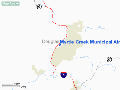
Myrtle Creek Municipal Airport (FAA LID: 16S), is a public airport located two miles (3.2 km) southwest of Myrtle Creek in Douglas County, Oregon, USA.
The above content comes from Wikipedia and is published under free licenses – click here to read more.
Location & QuickFacts
| FAA Information Effective: | 2008-09-25 |
| Airport Identifier: | 16S |
| Airport Status: | Operational |
| Longitude/Latitude: | 123-18-55.2500W/42-59-50.1400N
-123.315347/42.997261 (Estimated) |
| Elevation: | 619 ft / 188.67 m (Estimated) |
| Land: | 81 acres |
| From nearest city: | 2 nautical miles SW of Myrtle Creek, OR |
| Location: | Douglas County, OR |
| Magnetic Variation: | 18E (1985) |
Owner & Manager
| Ownership: | Publicly owned |
| Owner: | City Of Myrtle Creek |
| Address: | Po Box 940
Myrtle Creek, OR 97457 |
| Phone number: | 541-863-3171 |
| Manager: | Aaron Cubic, City Mgr |
| Address: | Po Box 940
Myrtle Creek, OR 97457 |
| Phone number: | 541-863-3171 |
Airport Operations and Facilities
| Airport Use: | Open to public |
| Wind indicator: | Yes |
| Segmented Circle: | Yes |
| Control Tower: | No |
| Lighting Schedule: | DUSK-DAWN
ACTIVATE MIRL RYS 03/21, REIL RY 03 & PAPI RY 03 - CTAF |
| Beacon Color: | Clear-Green (lighted land airport) |
| Landing fee charge: | No |
| Sectional chart: | Klamath Falls |
| Region: | ANM - Northwest Mountain |
| Traffic Pattern Alt: | 981 ft |
| Boundary ARTCC: | ZSE - Seattle |
| Tie-in FSS: | MMV - Mc Minnville |
| FSS on Airport: | No |
| FSS Toll Free: | 1-800-WX-BRIEF |
| NOTAMs Facility: | MMV (NOTAM-d service avaliable) |
| Federal Agreements: | NGY |
Airport Communications
| CTAF: | 122.700 |
| Unicom: | 122.700
UNICOM UNMONITORED INDEFLY. |
Airport Services
| Bottled Oxygen: | NONE |
| Bulk Oxygen: | NONE |
Runway Information
Runway 03/21
| Dimension: | 2600 x 60 ft / 792.5 x 18.3 m |
| Surface: | ASPH, Good Condition |
| Weight Limit: | Single wheel: 12000 lbs. |
| Edge Lights: | Medium |
| |
Runway 03 |
Runway 21 |
| Longitude: | 123-19-08.6168W | 123-18-41.8792W |
| Latitude: | 42-59-41.8520N | 42-59-58.4228N |
| Elevation: | 614.00 ft | 619.00 ft |
| Traffic Pattern: | Right | Left |
| Markings: | Basic, Good Condition | Basic, Good Condition |
| Crossing Height: | 41.00 ft | 0.00 ft |
| VASI: | 2-light PAPI on left side | |
| Visual Glide Angle: | 4.00° | 0.00° |
| Runway End Identifier: | Yes | |
| Centerline Lights: | No | |
| Touchdown Lights: | No | |
| Obstruction: | 48 ft tree, 993.0 ft from runway, 125 ft right of centerline, 16:1 slope to clear | 25 ft trees, 1146.0 ft from runway, 150 ft left of centerline, 37:1 slope to clear |
|
Radio Navigation Aids
| ID |
Type |
Name |
Ch |
Freq |
Var |
Dist |
| RBG | NDB | Roseburg | | 400.00 | 20E | 14.4 nm |
| MEF | NDB | Medford | | 356.00 | 19E | 41.2 nm |
| RBG | VOR/DME | Roseburg | 019X | 108.20 | 20E | 11.2 nm |
| OED | VORTAC | Rogue Valley | 083X | 113.60 | 19E | 35.8 nm |
| OTH | VORTAC | North Bend | 058X | 112.10 | 18E | 45.0 nm |
| MFR | VOT | Medford-jackson County | | 117.20 | | 43.2 nm |
Remarks
- 198' LGTD TOWER 1.3 NM NORTH - NORTHWEST MSL ELEV 2122 OBSTRUCTS VFR ROUTE.
- TERRAIN RISES TO 2200 FT MSL WITHIN 2 MILES ON EACH SIDE OF RY.
Images and information placed above are from
http://www.airport-data.com/airport/16S/
We thank them for the data!
| General Info
|
| Country |
United States
|
| State |
OREGON
|
| FAA ID |
16S
|
| Latitude |
42-59-54.422N
|
| Longitude |
123-18-34.233W
|
| Elevation |
619 feet
|
| Near City |
MYRTLE CREEK
|
We don't guarantee the information is fresh and accurate. The data may
be wrong or outdated.
For more up-to-date information please refer to other sources.
|
|


