|
|
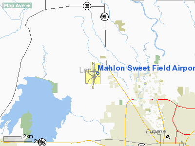
Mahlon Sweet Field Airport |
Eugene Airport
Mahlon Sweet Field |
 |
| IATA: EUG – ICAO: KEUG – FAA LID: EUG |
| Summary |
| Airport type |
Public |
| Operator |
City of Eugene |
| Location |
Lane County, near Eugene, Oregon |
| Elevation AMSL |
374 ft / 114 m |
| Coordinates |
44°07′23″N 123°13′07″W / 44.12306°N 123.21861°W / 44.12306; -123.21861 |
| Website |
www.flyeug.com |
| Runways |
| Direction |
Length |
Surface |
| ft |
m |
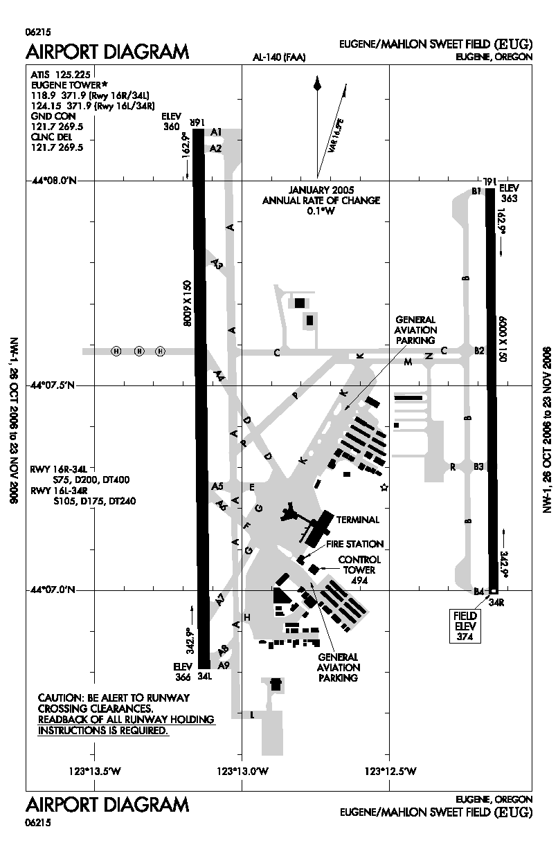
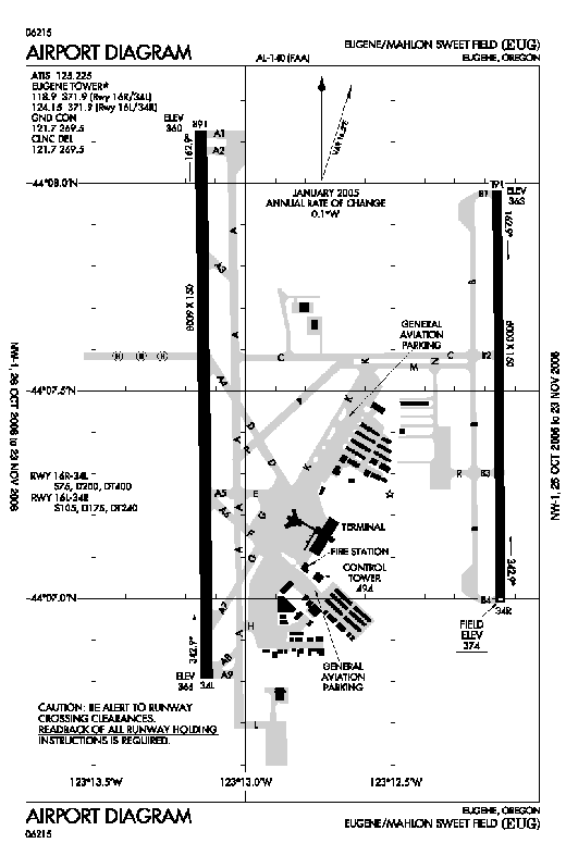
| 16R/34L |
8,009 |
2,441 |
Asphalt |
| 16L/34R |
6,000 |
1,829 |
Asphalt |
Eugene Airport (IATA: EUG, ICAO: KEUG, FAA LID: EUG), also known as Mahlon Sweet Field, is a public airport located 7 miles (11 km) northwest of Eugene, in Lane County, Oregon. Owned and operated by the City of Eugene, it is the fifth-largest airport in the Pacific Northwest, providing commercial air service to a six-county region in mid-Oregon. The modern terminal building has "A" gates on the upper level and "B" gates, ticketing, and baggage claim on the lower level. The airport also has an expanded air cargo facility to serve the growing air cargo demands of the region, and two fixed base operators (FBOs) to handle general aviation needs. The airport served approximately 740,000 passengers in 2007.
The airport was named for Mahlon Sweet (1886 - 1947), a Eugene automobile dealer who was a strong supporter of aviation and pushed to get the now-defunct Eugene Air Park built in 1919, followed by the current airfield in 1943. Airlines and destinations
Eugene Airport is served by four air carriers:
| Airlines |
Destinations |
| Allegiant Air |
Las Vegas, Los Angeles, Oakland, Phoenix/Mesa |
| Delta Connection operated by SkyWest Airlines |
Salt Lake City |
| Horizon Air |
Portland, Seattle/Tacoma |
| United Express operated by SkyWest Airlines |
Denver, Portland, San Francisco |
General aviation
There are two fixed based operators on field that cater to general aviation, Flightcraft and Friendly Air Service. Flightcraft specializes in maintenance and working on larger GA aircraft like Gulfstreams and Learjets. They are the only on-airport company that has fuel trucks. Friendly Air Service rents Cessna 172s and offers flight training.
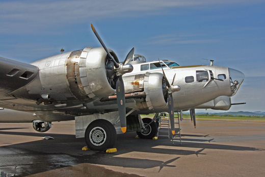 | |
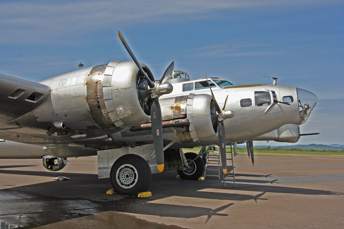
A B-17 Flying Fortress at the airport |
Mahlon Sweet is also home to the Lane Community College Flight academy. LCC's Flight Technology Center provides flight instruction for private, commercial, instrument, multi-engine and flight instructor. Their fleet includes Cessna 172, Piper Warrior II, Piper Arrow IV, and a Piper Seminole.
Parking
The parking facility is attended 24 hours a day and contains 237 short-term and more than 1000 long-term parking spaces in the main lot, with an additional 582 spaces in the overflow lot. A shuttle service serves the overflow lot when in use.
History
During World War II the airfield was used by the United States Army Air Force.
The above content comes from Wikipedia and is published under free licenses – click here to read more.
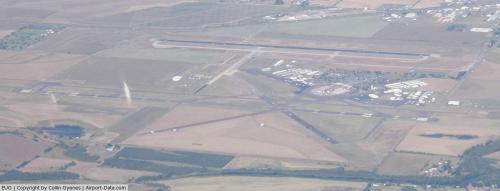 |
(Click on the photo to enlarge) |
Location & QuickFacts
| FAA Information Effective: | 2008-09-25 |
| Airport Identifier: | EUG |
| Airport Status: | Operational |
| Longitude/Latitude: | 123-12-43.1000W/44-07-28.5000N
-123.211972/44.124583 (Estimated) |
| Elevation: | 374 ft / 114.00 m (Surveyed) |
| Land: | 2600 acres |
| From nearest city: | 7 nautical miles NW of Eugene, OR |
| Location: | Lane County, OR |
| Magnetic Variation: | 19E (1985) |
Owner & Manager
| Ownership: | Publicly owned |
| Owner: | City Of Eugene |
| Address: | 777 Pearl
Eugene, OR 97401 |
| Phone number: | 541-682-5430 |
| Manager: | Tim M. Doll |
| Address: | 28855 Lockheed Drive
Eugene, OR 97402 |
| Phone number: | 541-682-5430 |
Airport Operations and Facilities
| Airport Use: | Open to public |
| Wind indicator: | Yes |
| Segmented Circle: | Yes |
| Control Tower: | Yes |
| Lighting Schedule: | DUSK-DAWN
HIRL RYS 16L/34R & 16R/34L ATCT CTL 0600-2330; MED INTST 2330-0600. PAPI 16R, & VASI RY 34L OPER 24 HRS. ALSF RY 16R & ODALS RY 34L, MALSR RY 16L, PAPI RYS 16L & 34R & REIL RY 34R, ATCT CTL 0600-2330. 2330-0600 ACTVT - CTAF. |
| Beacon Color: | Clear-Green (lighted land airport) |
| Landing fee charge: | No |
| Sectional chart: | Klamath Falls |
| Region: | ANM - Northwest Mountain |
| Traffic Pattern Alt: | 800 ft |
| Boundary ARTCC: | ZSE - Seattle |
| Tie-in FSS: | MMV - Mc Minnville |
| FSS on Airport: | No |
| FSS Toll Free: | 1-800-WX-BRIEF |
| NOTAMs Facility: | EUG (NOTAM-d service avaliable) |
| Certification type/date: | I B S 05/1973
PPR FOR UNSKED ACR OPNS WITH MORE THAN 30 PSGR SEATS CALL 541-682-5430. ARFF SVCS UNAVBL 0000-0500 LCL EXCP PPR 541-682-5430. |
| Federal Agreements: | NGY3 |
Airport Communications
| CTAF: | 118.900 |
| Unicom: | 122.950 |
Airport Services
| Fuel available: | 100LLA |
| Airframe Repair: | MAJOR |
| Power Plant Repair: | MAJOR |
| Bottled Oxygen: | HIGH/LOW |
| Bulk Oxygen: | HIGH/LOW |
Runway Information
Runway 16L/34R
| Dimension: | 6000 x 150 ft / 1828.8 x 45.7 m |
| Surface: | ASPH, Good Condition |
| Surface Treatment: | Saw-cut or plastic Grooved |
| Weight Limit: | Single wheel: 105000 lbs.
Dual wheel: 175000 lbs.
Dual tandem wheel: 240000 lbs. |
| Edge Lights: | High |
| |
Runway 16L |
Runway 34R |
| Longitude: | 123-12-09.8273W | 123-12-08.9493W |
| Latitude: | 44-07-58.7050N | 44-06-59.4593N |
| Elevation: | 363.00 ft | 374.00 ft |
| Alignment: | 127 | 127 |
| ILS Type: | ILS/DME
| |
| Traffic Pattern: | Left | Left |
| Markings: | Basic, Good Condition | Precision instrument, Good Condition |
| Crossing Height: | 52.00 ft | 50.00 ft |
| VASI: | 4-light PAPI on left side | 4-light PAPI on left side |
| Visual Glide Angle: | 3.00° | 3.00° |
| Approach lights: | MALSR | |
| Runway End Identifier: | | Yes |
|
Runway 16R/34L
| Dimension: | 8009 x 150 ft / 2441.1 x 45.7 m |
| Surface: | ASPH, Good Condition |
| Surface Treatment: | Saw-cut or plastic Grooved |
| Weight Limit: | Single wheel: 75000 lbs.
Dual wheel: 200000 lbs.
Dual tandem wheel: 400000 lbs. |
| Edge Lights: | High |
| |
Runway 16R |
Runway 34L |
| Longitude: | 123-13-08.9357W | 123-13-07.7401W |
| Latitude: | 44-08-07.6110N | 44-06-48.5240N |
| Elevation: | 360.00 ft | 366.00 ft |
| Alignment: | 127 | 127 |
| ILS Type: | ILS/DME
| |
| Traffic Pattern: | Left | Left |
| Markings: | Precision instrument, Good Condition | Precision instrument, Good Condition |
| Crossing Height: | 50.00 ft | 53.00 ft |
| VASI: | 4-light PAPI on left side | 4-box on left side |
| Visual Glide Angle: | 3.00° | 3.00° |
| RVR Equipment: | touchdown | |
| Approach lights: | ALSF2 | ODALS |
| Centerline Lights: | Yes | Yes |
| Touchdown Lights: | Yes | No |
|
Radio Navigation Aids
| ID |
Type |
Name |
Ch |
Freq |
Var |
Dist |
| EU | NDB | Frakk | | 260.00 | 19E | 5.3 nm |
| LWG | NDB | Lewisburg | | 225.00 | 18E | 29.5 nm |
| CVO | VOR/DME | Corvallis | 101X | 115.40 | 18E | 22.8 nm |
| EUG | VORTAC | Eugene | 076X | 112.90 | 20E | 0.5 nm |
| ONP | VORTAC | Newport | 118X | 117.10 | 19E | 45.4 nm |
Remarks
- MIGRATORY WATERFOWL & OTR BIRDS ON & INVOF ARPT.
- TWYS H & K UNAVBL TO ACFT 21000 LBS SW & 40000 LBS DW GWT.
- PSBL UP/DOWN DRAFTS & RESTRICTED VSBY DUE TO FIELD BURNING BTWN JUL-SEP.
- TRML APRON CLSD TO ACFT EXCP SKEDD ACRS & FLTS WITH PRIOR PMSN.
- HELIPADS W OF RY 16R RESTRICTED; PPR PHONE 541-682-5430.
- HELS LNDG AND DEPARTING AVOID OVERFLYING THE AIRLINE PSGR TRML AND RAMP LCTD E OF RY 16R/34L.
- NO ACCESS TO RY 34L BEYOND TWY A9.
Images and information placed above are from
http://www.airport-data.com/airport/EUG/
We thank them for the data!
| General Info
|
| Country |
United States
|
| State |
OREGON
|
| FAA ID |
EUG
|
| Latitude |
44-07-23.736N
|
| Longitude |
123-13-07.268W
|
| Elevation |
369 feet
|
| Near City |
EUGENE
|
We don't guarantee the information is fresh and accurate. The data may
be wrong or outdated.
For more up-to-date information please refer to other sources.
|
|