|
|
Klamath Falls Airport
Kingsley Field |
 |
| IATA: LMT – ICAO: KLMT |
| Summary |
| Airport type |
Public |
| Operator |
City of Klamath Falls |
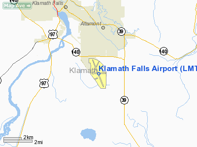
| Location |
Klamath Falls, Oregon |
| Elevation AMSL |
4,095 ft / 1,248 m |
| Coordinates |
42°09′22″N 121°43′59″W / 42.15611°N 121.73306°W / 42.15611; -121.73306Coordinates: 42°09′22″N 121°43′59″W / 42.15611°N 121.73306°W / 42.15611; -121.73306 |
| Runways |
| Direction |
Length |
Surface |
| ft |
m |
| 14/32 |
10,301 |
3,140 |
Asphalt/Concrete |
| 7/25 |
5,260 |
1,603 |
Asphalt |
Klamath Falls Airport (IATA: LMT, ICAO: KLMT), also known as Kingsley Field, is a joint civil-military public airport located four miles (6 km) southeast of Klamath Falls, in Klamath County, Oregon, USA. The airport has two runways. It is mostly used for military and general aviation, but also has limited commercial service.
As an Air National Guard base, the airport serves as the home of the Oregon Air National Guard's 173d Fighter Wing (173 FW) flying the F-15 Eagle. An Air Education and Training Command (AETC)-gained unit, the 173 FW specializes as an advanced air-to-air combat training center for Regular Air Force and Air National Guard F-15 pilots, as well as hosting joint and combined air combat exercises for all US military services and those of Canada. Kingsley Field is also home to a USAF flight surgeon training school. The 173d Fighter Wing is currently under the command of Colonel James C Miller.
In 1928 the citizens of Klamath Falls approved the sale of $50,000 worth of bonds to construct an airport. The airport was known as the Klamath Falls Municipal Airport and consisted of gravel runways and one Fixed Base Operator. In 1942, the airport was selected as a site for a Naval Air Station subsequently named NAS Klamath Falls. In 1945, the airport transferred back to civilian use.
In 1954, the airport was selected as a site for U.S. Air Force installation under a joint civil-military arrangement supporting Air Defense Command, later Aerospace Defense Command (ADC) aircraft and squadrons. In 1957, the airport was dedicated as Kingsley Field in honor of First Lieutenant David David R. Kingsley, USAAF, an Oregonian killed in action on June 23, 1944 after a B-24 bombing mission over the oil fields of Ploesti, Rumania. In 1976, ADC was inactivated and control of the military installation passed to Tactical Air Command (TAC). In 1978, the Department of Defense chose to close Kingsley Field as a regular Air Force installation, transferring all military facilities to the Air National Guard.
Airline
| Airlines |
Destinations |
| United Express operated by SkyWest Airlines |
Portland (OR), San Francisco |
The above content comes from Wikipedia and is published under free licenses – click here to read more.
Location & QuickFacts
| FAA Information Effective: | 2008-09-25 |
| Airport Identifier: | LMT |
| Airport Status: | Operational |
| Longitude/Latitude: | 121-43-59.5000W/42-09-22.1000N
-121.733194/42.156139 (Estimated) |
| Elevation: | 4095 ft / 1248.16 m (Surveyed) |
| Land: | 1166 acres |
| From nearest city: | 4 nautical miles SE of Klamath Falls, OR |
| Location: | Klamath County, OR |
| Magnetic Variation: | 17E (1990) |
Owner & Manager
| Ownership: | Publicly owned |
| Owner: | City Of Klamath Falls |
| Address: | City Hall Po Box 237
Klamath Falls, OR 97601 |
| Phone number: | 541-883-5316 |
| Manager: | Ann Crook |
| Address: | 6775 Arnold Avenue
Klamath Falls, OR 97603 |
| Phone number: | 541-883-5372 |
Airport Operations and Facilities
| Airport Use: | Open to public |
| Wind indicator: | Yes |
| Segmented Circle: | No |
| Control Tower: | Yes |
| Lighting Schedule: | DUSK-DAWN
WHEN ATCT CLSD ACTVT MALSF RY 14, MALSR RY 32, HIRL RY 14/32, MIRL 07/25 AND TWY LGTS - CTAF. RY AND TWY LGTS ALSO ACTVT ON 257.8. RY LGTS HAVE A 30 SECOND WARM UP DELAY. |
| Beacon Color: | Clear-Green (lighted land airport) |
| Landing fee charge: | No |
| Sectional chart: | Klamath Falls |
| Region: | ANM - Northwest Mountain |
| Boundary ARTCC: | ZSE - Seattle |
| Tie-in FSS: | MMV - Mc Minnville |
| FSS on Airport: | No |
| FSS Toll Free: | 1-800-WX-BRIEF |
| NOTAMs Facility: | LMT (NOTAM-d service avaliable) |
| Certification type/date: | I A S 05/1973 |
| Federal Agreements: | NGPSY |
Airport Communications
| CTAF: | 118.200 |
| Unicom: | 122.950 |
Airport Services
| Fuel available: | 100LLA |
| Airframe Repair: | MAJOR |
| Power Plant Repair: | MAJOR |
| Bottled Oxygen: | HIGH |
| Bulk Oxygen: | HIGH |
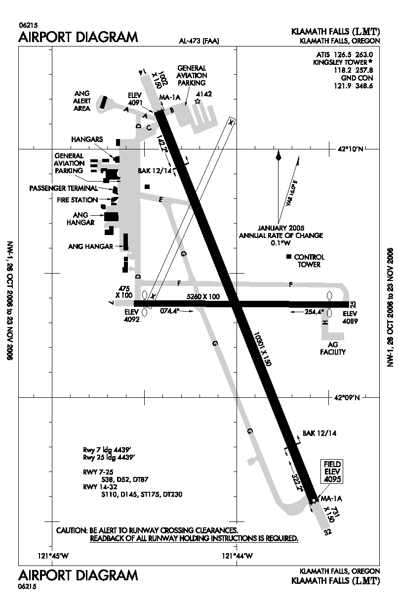
Runway Information
Runway 07/25
| Dimension: | 5258 x 100 ft / 1602.6 x 30.5 m |
| Surface: | ASPH, Good Condition |
| Surface Treatment: | Saw-cut or plastic Grooved |
| Weight Limit: | Single wheel: 38000 lbs.
Dual wheel: 52000 lbs.
Dual tandem wheel: 87000 lbs. |
| Edge Lights: | Medium |
| |
Runway 07 |
Runway 25 |
| Longitude: | 121-44-33.3436W | 121-43-23.5489W |
| Latitude: | 42-09-22.7466N | 42-09-22.3655N |
| Elevation: | 4092.00 ft | 4089.00 ft |
| Alignment: | 90 | 127 |
| Traffic Pattern: | Left | Left |
| Markings: | Basic, Good Condition | Basic, Good Condition |
| Crossing Height: | 0.00 ft | 40.00 ft |
| Displaced threshold: | 306.00 ft | 512.00 ft |
| VASI: | | 4-light PAPI on left side |
| Visual Glide Angle: | 0.00° | 3.00° |
| Runway End Identifier: | | Yes |
| Obstruction: | 25 ft rr, 625.0 ft from runway, 125 ft right of centerline, 16:1 slope to clear
APCH SLOPE 29:1 TO DSPLCD THR. | 6 ft fence, 200.0 ft from runway, 125 ft right of centerline
APCH SLOPE 34:1 TO DSPLCD THLD. |
| Decleard distances: | Take off run available 5260.00 ft
Take off distance available 5260.00 ft
Actual stop distance available 4746.00 ft
Landing distance available 4439.00 ft
| Take off run available 5260.00 ft
Take off distance available 5260.00 ft
Actual stop distance available 4953.00 ft
Landing distance available 4439.00 ft
|
|
Runway 14/32
| Dimension: | 10302 x 150 ft / 3140.0 x 45.7 m |
| Surface: | ASPH-CONC, Good Condition |
| Weight Limit: | Single wheel: 110000 lbs.
Dual wheel: 145000 lbs.
Dual tandem wheel: 230000 lbs. |
| Edge Lights: | High |
| |
Runway 14 |
Runway 32 |
| Longitude: | 121-44-25.4564W | 121-43-34.7369W |
| Latitude: | 42-10-09.1349N | 42-08-34.6472N |
| Elevation: | 4091.00 ft | 4095.00 ft |
| Alignment: | 127 | 127 |
| ILS Type: | | ILS
|
| Traffic Pattern: | Left | Left |
| Markings: | Precision instrument, Good Condition | Precision instrument, Good Condition |
| Arresting: | BAK14 | BAK14 |
| Crossing Height: | 50.00 ft | 50.00 ft |
| VASI: | 4-box on left side | 4-box on left side |
| Visual Glide Angle: | 3.00° | 3.00° |
| RVR Equipment: | | touchdown |
| Approach lights: | MALSF | MALSR |
| Obstruction: | 88 ft tree, 2400.0 ft from runway, 500 ft right of centerline, 27:1 slope to clear | , 50:1 slope to clear |
|
Radio Navigation Aids
| ID |
Type |
Name |
Ch |
Freq |
Var |
Dist |
| LFA | NDB | Merrill | | 347.00 | 17E | 11.0 nm |
| MOG | NDB | Montague | | 404.00 | 19E | 42.2 nm |
| LMT | VORTAC | Klamath Falls | 106X | 115.90 | 17E | 0.3 nm |
Remarks
- FLOCKS OF LARGE MIGRATORY WATERFOWL IN VICINITY NOV-MAY.
- RY 07 CLSD 2200-0700.
- ANG BASE OPS OPR 0800-1600 MON-FRI EXC HOL 339.7.
Images and information placed above are from
http://www.airport-data.com/airport/LMT/
We thank them for the data!
| General Info
|
| Country |
United States
|
| State |
OREGON
|
| FAA ID |
LMT
|
| Latitude |
42-09-22.117N
|
| Longitude |
121-43-59.549W
|
| Elevation |
4095 feet
|
| Near City |
KLAMATH FALLS
|
We don't guarantee the information is fresh and accurate. The data may
be wrong or outdated.
For more up-to-date information please refer to other sources.
|
|