|
|
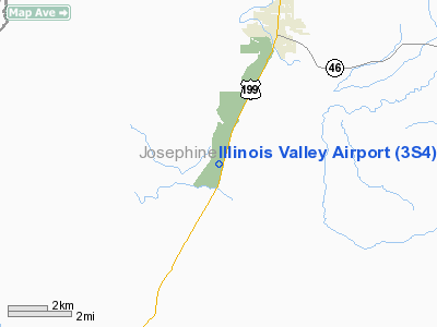
| Illinois Valley Airport |
 |
| IATA: none – ICAO: none – FAA LID: 3S4 |
| Summary |
| Airport type |
Public |
| Owner |
Josephine County Airports |
| Location |
Cave Junction, Oregon |
| Elevation AMSL |
1,394 ft / 425 m |
| Coordinates |
42°06′13″N 123°40′57″W / 42.10361°N 123.6825°W / 42.10361; -123.6825Coordinates: 42°06′13″N 123°40′57″W / 42.10361°N 123.6825°W / 42.10361; -123.6825 |
| Runways |
| Direction |
Length |
Surface |
| ft |
m |
| 18/36 |
4,807 |
1,465 |
Asphalt |
| Statistics (2004) |
| Aircraft operations |
6,000 |
| Based aircraft |
22 |
| Source: Federal Aviation Administration |
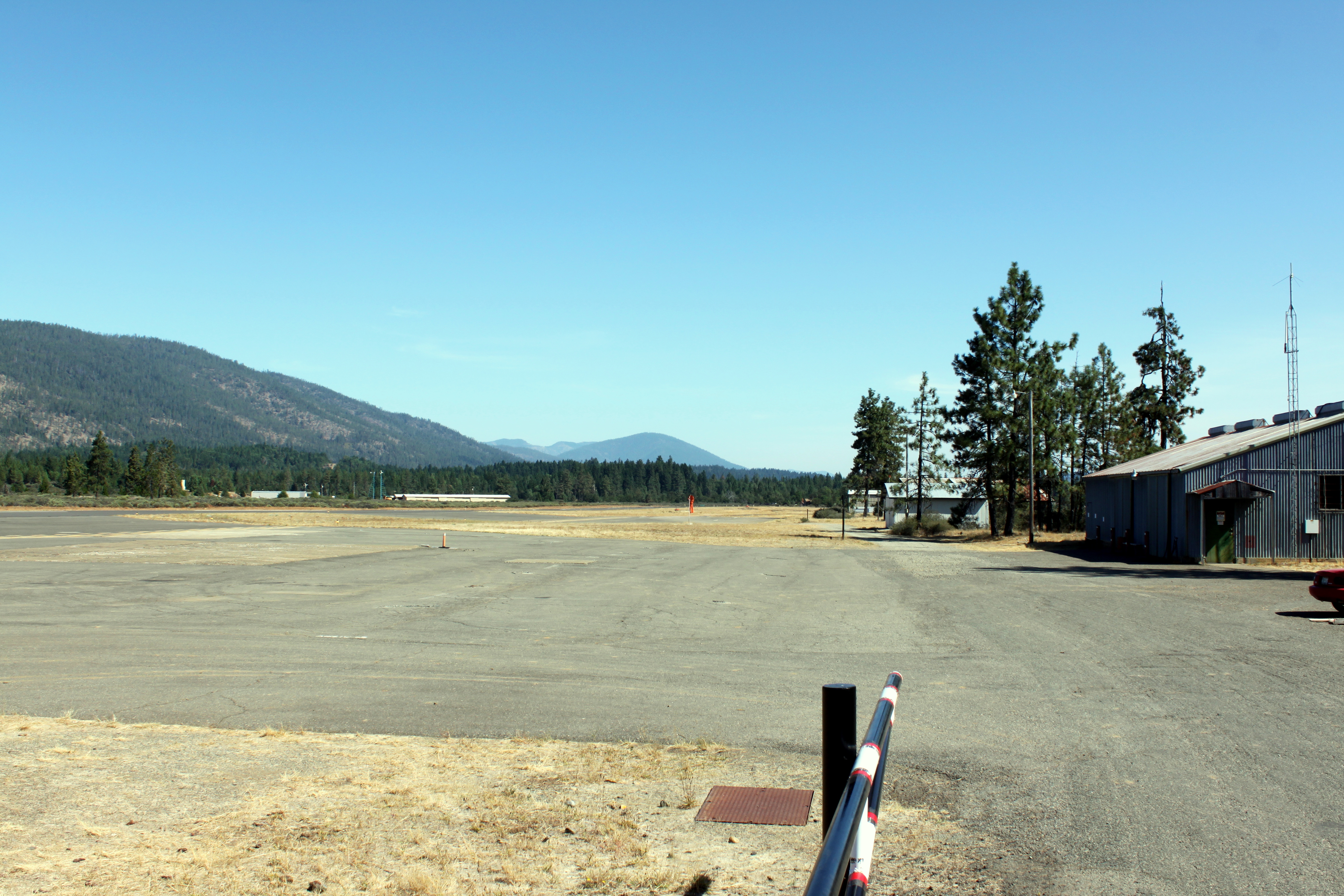
Illinois Valley Airport (FAA LID: 3S4) is a county-owned public-use airport located four miles (6.4 km) southwest of the central business district of Cave Junction, a city in Josephine County, Oregon, United States. History
The Illinois Valley Airport, also known as the Siskiyou Smokejumper Base,or even the Cave Junction Airport, was built by the US Forest Service. It operated from 1943 to 1981 as a smokejumper base, during which time the smokejumpers parachuted on 1445 fires for 5390 fire jumps, or about 142 jumps per year.
Moon Trees
Lunar orbiter commander Stuart Roosa was a firefighter at the Siskiyou Smokejumper Base in 1954. In 1971, Roosa took a packet of Douglas Fir seeds with him to the moon, and when he returned the Forest Service planted these "Moon Trees" across the US, including two at the Illinois Valley Airport. The smokejumpers cared for these trees, but after their departure, both trees died.
Facilities and aircraft
Illinois Valley Airport covers an area of 175 acres (71 ha) which contains one asphalt paved runway (18/36) measuring 4,807 x 75 ft (1,465 x 23 m). For the 12-month period ending December 31, 2004, the airport had 6,000 aircraft operations, all of which were general aviation.
The airport has a fixed base operator, aircraft rentals and instruction, hangar rentals, and a restaurant (closed) and a small campground. All other services are four miles (6 km) north in Cave Junction.
- Note: as of 1/2008 the FBO and restaurant are closed. Hopefully a new FBO and food will locate there soon.
The above content comes from Wikipedia and is published under free licenses – click here to read more.
Location & QuickFacts
| FAA Information Effective: | 2008-09-25 |
| Airport Identifier: | 3S4 |
| Airport Status: | Operational |
| Longitude/Latitude: | 123-40-56.7000W/42-06-12.9600N
-123.682417/42.103600 (Estimated) |
| Elevation: | 1394 ft / 424.89 m (Estimated) |
| Land: | 175 acres |
| From nearest city: | 4 nautical miles SW of Cave Junction, OR |
| Location: | Josephine County, OR |
| Magnetic Variation: | 18E (1985) |
Owner & Manager
| Ownership: | Publicly owned |
| Owner: | Josephine County Airports |
| Address: | 1441 Brookside Blvd
Grants Pass, OR 97526 |
| Phone number: | 541-955-4535 |
| Manager: | Alex Grossi |
| Address: | 1441 Brookside Blvd
Grants Pass, OR 97526 |
| Phone number: | 541-955-4535 |
Airport Operations and Facilities
| Airport Use: | Open to public |
| Wind indicator: | Yes |
| Segmented Circle: | Yes |
| Control Tower: | No |
| Lighting Schedule: | DUSK-DAWN
ACTVT LIRL RY 18/36 - CTAF. |
| Beacon Color: | Clear-Green (lighted land airport) |
| Landing fee charge: | No |
| Sectional chart: | Klamath Falls |
| Region: | ANM - Northwest Mountain |
| Traffic Pattern Alt: | 1000 ft |
| Boundary ARTCC: | ZSE - Seattle |
| Tie-in FSS: | MMV - Mc Minnville |
| FSS on Airport: | No |
| FSS Toll Free: | 1-800-WX-BRIEF |
| NOTAMs Facility: | MMV (NOTAM-d service avaliable) |
| Federal Agreements: | NGY |
Airport Communications
| CTAF: | 122.800 |
| Unicom: | 122.800
UNICOM ATTENDED IREG. |
Airport Services
| Airframe Repair: | NONE |
| Power Plant Repair: | NONE |
| Bottled Oxygen: | NONE |
| Bulk Oxygen: | NONE |
Runway Information
Runway 18/36
| Dimension: | 4807 x 75 ft / 1465.2 x 22.9 m |
| Surface: | ASPH, Good Condition |
| Weight Limit: | Single wheel: 20000 lbs.
Dual wheel: 30000 lbs. |
| Edge Lights: | Low |
| |
Runway 18 |
Runway 36 |
| Longitude: | 123-40-47.5840W | 123-41-05.8147W |
| Latitude: | 42-06-35.7130N | 42-05-50.2084N |
| Elevation: | 1353.00 ft | 1394.00 ft |
| Traffic Pattern: | Left | Left |
| Markings: | Basic, Good Condition | Basic, Good Condition |
| Crossing Height: | 34.00 ft | 31.00 ft |
| Displaced threshold: | 125.00 ft | 0.00 ft |
| VASI: | 2-box on left side
18/36 VASI OTS INDEFLY. | 2-box on left side |
| Visual Glide Angle: | 3.00° | 3.00° |
| Obstruction: | 15 ft road, 310.0 ft from runway, 15:1 slope to clear
RWY 18 140' TREES AT 1950 ON CL 13:1 BASED ON DISPLCD THLD.
RWY 18 +15 FT ROAD AT 90 FT & +4 FT FENCE AT 40 FT 13:1 BASED ON DSPLCD THLD | 55 ft trees, 685.0 ft from runway, 115 ft right of centerline, 8:1 slope to clear |
|
Radio Navigation Aids
| ID |
Type |
Name |
Ch |
Freq |
Var |
Dist |
| MEF | NDB | Medford | | 356.00 | 19E | 39.7 nm |
| CEC | VORTAC | Crescent City | 027X | 109.00 | 19E | 31.7 nm |
| OED | VORTAC | Rogue Valley | 083X | 113.60 | 19E | 41.0 nm |
| MFR | VOT | Medford-jackson County | | 117.20 | | 39.4 nm |
Remarks
- RY 36 DESIGNATED CALM WIND RY.
- FREQUENT ULTRA-LIGHT ACTIVITY.
- ESTABD PRIOR TO 1959.
Images and information placed above are from
http://www.airport-data.com/airport/3S4/
We thank them for the data!
| General Info
|
| Country |
United States
|
| State |
OREGON
|
| FAA ID |
3S4
|
| Latitude |
42-06-13.407N
|
| Longitude |
123-40-56.248W
|
| Elevation |
1394 feet
|
| Near City |
CAVE JUNCTION
|
We don't guarantee the information is fresh and accurate. The data may
be wrong or outdated.
For more up-to-date information please refer to other sources.
|
|