 |
|
- For the airport in Houston, see William P. Hobby Airport.
| Hobby Field |
| IATA: none – ICAO: none – FAA LID: 77S |
| Summary |
| Airport type |
Public |
| Operator |
City of Creswell |
| Location |
Creswell, Oregon |
| Elevation AMSL |
538 ft / 164 m |
| Coordinates |
43°55′50.7600″N 123°00′26.2017″W / 43.9307667°N 123.00727825°W / 43.9307667; -123.00727825Coordinates: 43°55′50.7600″N 123°00′26.2017″W / 43.9307667°N 123.00727825°W / 43.9307667; -123.00727825 |
| Runways |
| Direction |
Length |
Surface |
| ft |
m |
| 15/33 |
3101 |
945 |
Asphalt |
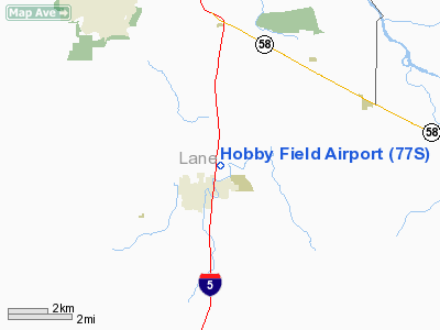
Hobby Field (FAA LID: 77S), is a public airport located one mile (1.6 km) northeast of the city of Creswell in Lane County, Oregon, United States.
The above content comes from Wikipedia and is published under free licenses – click here to read more.
Location & QuickFacts
| FAA Information Effective: | 2008-09-25 |
| Airport Identifier: | 77S |
| Airport Status: | Operational |
| Longitude/Latitude: | 123-00-26.2017W/43-55-50.7600N
-123.007278/43.930767 (Estimated) |
| Elevation: | 538 ft / 163.98 m (Surveyed) |
| Land: | 96 acres |
| From nearest city: | 1 nautical miles NE of Creswell, OR |
| Location: | Lane County, OR |
| Magnetic Variation: | 19E (1985) |
Owner & Manager
| Ownership: | Publicly owned |
| Owner: | City Of Creswell |
| Address: | Po Box 276
Creswell, OR 97426 |
| Phone number: | 541-895-2531 |
| Manager: | Shelly Humble |
| Address: | 83501 N. Melton Road
Creswell, OR 97426 |
| Phone number: | 541-895-2913 |
Airport Operations and Facilities
| Airport Use: | Open to public |
| Wind indicator: | Yes |
| Segmented Circle: | Yes |
| Control Tower: | No |
| Lighting Schedule: | DUSK-DAWN
ACTIVATE MIRL RY 15/33 & PAPI RY 15 - CTAF. |
| Beacon Color: | Clear-Green (lighted land airport) |
| Landing fee charge: | No |
| Sectional chart: | Klamath Falls |
| Region: | ANM - Northwest Mountain |
| Traffic Pattern Alt: | 865 ft |
| Boundary ARTCC: | ZSE - Seattle |
| Tie-in FSS: | MMV - Mc Minnville |
| FSS on Airport: | No |
| FSS Toll Free: | 1-800-WX-BRIEF |
| NOTAMs Facility: | MMV (NOTAM-d service avaliable) |
| Federal Agreements: | NGY |
Airport Communications
| CTAF: | 122.700 |
| Unicom: | 122.700 |
Airport Services
| Fuel available: | 100LLA
SELF SERVE FUEL AVAILABLE 24 HRS. |
| Airframe Repair: | MAJOR |
| Power Plant Repair: | MAJOR |
| Bottled Oxygen: | NONE |
| Bulk Oxygen: | NONE |
Runway Information
Runway 15/33
| Dimension: | 3101 x 60 ft / 945.2 x 18.3 m |
| Surface: | ASPH, Good Condition |
| Weight Limit: | Single wheel: 12000 lbs. |
| Edge Lights: | Medium |
| |
Runway 15 |
Runway 33 |
| Longitude: | 123-00-26.2017W | 123-00-21.8900W |
| Latitude: | 43-56-05.9883N | 43-55-35.5223N |
| Elevation: | 538.00 ft | 536.00 ft |
| Alignment: | 127 | 127 |
| Traffic Pattern: | Left | Left |
| Markings: | Basic, Good Condition | Basic, Good Condition |
| VASI: | 2-light PAPI on left side | |
| Visual Glide Angle: | 3.00° | 0.00° |
| Obstruction: | 35 ft tree, 1210.0 ft from runway, 180 ft right of centerline, 28:1 slope to clear | 28 ft trees, 675.0 ft from runway, 16:1 slope to clear |
|
Radio Navigation Aids
| ID |
Type |
Name |
Ch |
Freq |
Var |
Dist |
| EU | NDB | Frakk | | 260.00 | 19E | 19.3 nm |
| LWG | NDB | Lewisburg | | 225.00 | 18E | 42.6 nm |
| RBG | NDB | Roseburg | | 400.00 | 20E | 44.5 nm |
| CVO | VOR/DME | Corvallis | 101X | 115.40 | 18E | 36.3 nm |
| RBG | VOR/DME | Roseburg | 019X | 108.20 | 20E | 47.4 nm |
| EUG | VORTAC | Eugene | 076X | 112.90 | 20E | 14.7 nm |
Remarks
Images and information placed above are from
http://www.airport-data.com/airport/77S/
We thank them for the data!
| General Info
|
| Country |
United States
|
| State |
OREGON
|
| FAA ID |
77S
|
| Latitude |
43-55-55.448N
|
| Longitude |
123-00-24.294W
|
| Elevation |
535 feet
|
| Near City |
CRESWELL
|
We don't guarantee the information is fresh and accurate. The data may
be wrong or outdated.
For more up-to-date information please refer to other sources.
|
|


