 |
|
Columbia Gorge Rgnl/the Dalles Muni Airport |
Coordinates: 45°37′07″N 121°10′02″W / 45.61861°N 121.16722°W / 45.61861; -121.16722
Columbia Gorge Regional Airport
The Dalles Municipal Airport |
 |
| IATA: DLS – ICAO: KDLS – FAA LID: DLS |
| Summary |
| Airport type |
Public |
| Owner |
City of The Dalles, Oregon & Klickitat County, Washington |
| Serves |
The Dalles, Oregon |
| Location |
Dallesport, Washington |
| Elevation AMSL |
247 ft / 75 m |
| Website |
thedallesairport.com |
| Runways |
| Direction |
Length |
Surface |
| ft |
m |
| 7/25 |
4,647 |
1,416 |
Asphalt |
| 12/30 |
5,097 |
1,554 |
Asphalt |
| Statistics (2007) |
| Aircraft operations |
16,282 |
| Based aircraft |
57 |
| Source: Federal Aviation Administration |
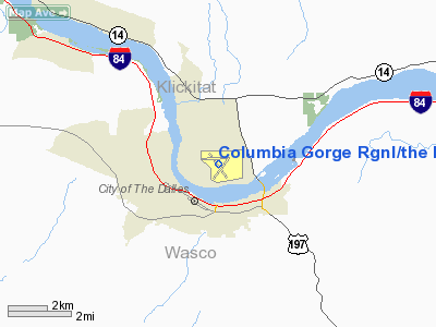
Columbia Gorge Regional Airport (IATA: DLS, ICAO: KDLS, FAA LID: DLS), also referred to as The Dalles Municipal Airport, is a public airport located in Klickitat County in the U.S. state of Washington, two miles (3 km) northeast of the city of The Dalles in the state of Oregon. The airport is jointly owned by the city of The Dalles and Klickitat County. It is adjacent to the Columbia River, near the east end of the Columbia River Gorge National Scenic Area. History
During the Great Depression, the city was granted $12,000 by the Works Progress Administration (WPA), but that was later revoked in 1935 when the WPA learned the city only leased the airport.
Facilities and aircraft
Columbia Gorge Regional Airport covers an area of 997 acres (403 ha) which contains two asphalt paved runways: 7/25 measuring 4,647 x 100 ft (1,416 x 30 m) and 12/30 measuring 5,097 x 100 ft (1,554 x 30 m).
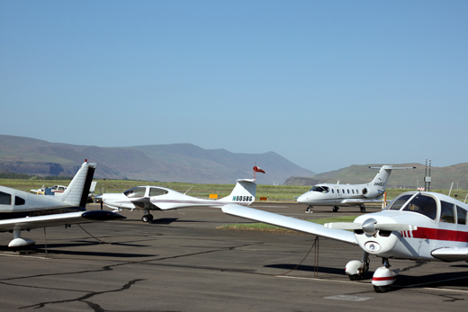
For the 12-month period ending July 10, 2007, the airport had 16,282 aircraft operations, an average of 44 per day: 84% general aviation, 11% air taxi and 5% military. At that time there were 57 aircraft based at this airport: 88% single-engine, 5% multi-engine, 4% jet and 4% helicopter.
The above content comes from Wikipedia and is published under free licenses – click here to read more.
Location & QuickFacts
| FAA Information Effective: | 2008-09-25 |
| Airport Identifier: | DLS |
| Airport Status: | Operational |
| Longitude/Latitude: | 121-10-02.4000W/45-37-06.8000N
-121.167333/45.618556 (Estimated) |
| Elevation: | 247 ft / 75.29 m (Surveyed) |
| Land: | 997 acres |
| From nearest city: | 2 nautical miles NE of The Dalles, OR |
| Location: | Klickitat County, WA |
| Magnetic Variation: | 19E (1985) |
Owner & Manager
| Ownership: | Publicly owned |
| Owner: | City Of The Dalles/klickitat Co |
| Address: | P.o. Box 285
Dalles Port, WA 98617 |
| Phone number: | 509-767-2272 |
| Manager: | Jim Lehman |
| Address: | Airport Manager, Po Box 285
Dallesport, WA 98617 |
| Phone number: | 509-767-2272 |
Airport Operations and Facilities
| Airport Use: | Open to public |
| Wind indicator: | Yes |
| Segmented Circle: | Yes |
| Control Tower: | No |
| Lighting Schedule: | DUSK-DAWN
ACTVT MIRL RYS 12/30 & 07/25, & REIL RY 30 - CTAF. |
| Beacon Color: | Clear-Green (lighted land airport) |
| Landing fee charge: | No |
| Sectional chart: | Seattle |
| Region: | ANM - Northwest Mountain |
| Boundary ARTCC: | ZSE - Seattle |
| Tie-in FSS: | SEA - Seattle |
| FSS on Airport: | No |
| FSS Toll Free: | 1-800-WX-BRIEF |
| NOTAMs Facility: | DLS (NOTAM-d service avaliable) |
| Federal Agreements: | NGY3 |
Airport Communications
| CTAF: | 123.000 |
| Unicom: | 123.000 |
Airport Services
| Fuel available: | 100LLA1 |
| Airframe Repair: | MAJOR |
| Power Plant Repair: | MAJOR |
| Bottled Oxygen: | NONE |
| Bulk Oxygen: | NONE |
Runway Information
Runway 07/25
| Dimension: | 4647 x 100 ft / 1416.4 x 30.5 m |
| Surface: | ASPH, Good Condition |
| Weight Limit: | Single wheel: 30000 lbs.
Dual wheel: 30000 lbs. |
| Edge Lights: | Medium |
| |
Runway 07 |
Runway 25 |
| Longitude: | 121-10-40.8650W | 121-09-35.5300W |
| Latitude: | 45-37-14.8940N | 45-37-16.4880N |
| Elevation: | 211.00 ft | 243.00 ft |
| Alignment: | 88 | 127 |
| ILS Type: | | ILS/DME |
| Traffic Pattern: | Left | Left |
| Markings: | Basic, Good Condition | Basic, Good Condition |
| Displaced threshold: | 440.00 ft | 196.00 ft |
| Obstruction: | 17 ft trees, 500.0 ft from runway, 17:1 slope to clear
+ 14 FT ROAD, DIST 440 FT, 200 FT R, SLOPE 31:1 TO DSPLCD THLD.
+14 FTROAD, 0 FT FM END, 200 FT R. | , 50:1 slope to clear
THLD DSPLCD TO PROVIDE SAFETY AREA. |
|
Runway 12/30
| Dimension: | 5097 x 100 ft / 1553.6 x 30.5 m |
| Surface: | ASPH, Good Condition |
| Weight Limit: | Single wheel: 30000 lbs.
Dual wheel: 30000 lbs. |
| Edge Lights: | Medium |
| |
Runway 12 |
Runway 30 |
| Longitude: | 121-10-24.3770W | 121-09-42.8230W |
| Latitude: | 45-37-24.7020N | 45-36-43.6920N |
| Elevation: | 210.00 ft | 239.00 ft |
| Alignment: | 127 | 127 |
| Traffic Pattern: | Left | Left |
| Markings: | Basic, Good Condition | Basic, Good Condition |
| Displaced threshold: | 200.00 ft | 0.00 ft |
| Runway End Identifier: | | Yes |
| Obstruction: | 50 ft trees, 970.0 ft from runway, 15:1 slope to clear
RY 12 APCH SLOPE 19:1 TO DSPLCD THLD.
12' BRUSH AT 160' BOTH SIDES OF CENTERLINE | , 50:1 slope to clear |
|
Radio Navigation Aids
| ID |
Type |
Name |
Ch |
Freq |
Var |
Dist |
| LTJ | VOR/DME | Klickitat | 070X | 112.30 | 21E | 6.4 nm |
Remarks
- MTNS BYD 5000' APCH RY 30.
- ALL TWYS MARKED WITH REFLECTORS.
- WATERFOWL ON AND INVOF ARPT.
- PRIOR PERMISSION REQUIRED FOR OVERWEIGHT LNDGS.
- ESTABD PRIOR TO 1959.
Images and information placed above are from
http://www.airport-data.com/airport/DLS/
We thank them for the data!
| General Info
|
| Country |
United States
|
| State |
OREGON
|
| FAA ID |
DLS
|
| Latitude |
45-37-06.764N
|
| Longitude |
121-10-02.438W
|
| Elevation |
247 feet
|
| Near City |
THE DALLES
|
We don't guarantee the information is fresh and accurate. The data may
be wrong or outdated.
For more up-to-date information please refer to other sources.
|
|


