 |
|
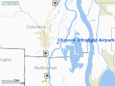
Chinook Ultralight Airpark Ultralight Airport |
Location & QuickFacts
| FAA Information Effective: | 2008-09-25 |
| Airport Identifier: | 52OR |
| Airport Status: | Operational |
| Longitude/Latitude: | 122-50-46.3700W/45-44-43.4120N
-122.846214/45.745392 (Estimated) |
| Elevation: | 40 ft / 12.19 m (Estimated) |
| Land: | 5 acres |
| From nearest city: | 3 nautical miles E of Scappoose, OR |
| Location: | Columbia County, OR |
| Magnetic Variation: | 20E (1985) |
Owner & Manager
| Ownership: | Privately owned |
| Owner: | Fred Bernet
LEASED TO COLUMBIA ULTRALIGHT INC. |
| Address: | Dike Rd
Scappoose, OR 97056 |
| Phone number: | 503-543-7686
OR 503-543-2693 |
| Manager: | Robert T Burgess
MEREL HEATH CO. COLUMBIA ULTRALIGHT INC. |
| Address: | Po Box 645
Scappoose, OR 97056 |
| Phone number: | 503-543-2693 |
Airport Operations and Facilities
| Airport Use: | Private
ULTRALIGHT TYPE ACFT ONLY, PERMISSION NEEDED. |
| Wind indicator: | Yes |
| Segmented Circle: | No |
| Control Tower: | No |
| Landing fee charge: | Yes |
| Sectional chart: | Seattle |
| Region: | ANM - Northwest Mountain |
| Boundary ARTCC: | ZSE - Seattle |
| Tie-in FSS: | MMV - Mc Minnville |
| FSS on Airport: | No |
| FSS Toll Free: | 1-800-WX-BRIEF |
Runway Information
Runway 14/32
| Dimension: | 650 x 75 ft / 198.1 x 22.9 m |
| Surface: | TURF, |
| |
Runway 14 |
Runway 32 |
| Traffic Pattern: | Left | Left |
| Obstruction: | 40 ft pline, 800.0 ft from runway | |
|
Radio Navigation Aids
| ID |
Type |
Name |
Ch |
Freq |
Var |
Dist |
| PND | NDB | Banks | | 356.00 | 21E | 10.9 nm |
| LBH | NDB | Laker | | 332.00 | 20E | 20.3 nm |
| LSO | NDB | Kelso | | 256.00 | 21E | 24.8 nm |
| PEN | NDB | Karpen | | 201.00 | 20E | 39.0 nm |
| TDO | NDB | Toledo | | 219.00 | 20E | 43.9 nm |
| CBU | TACAN | Columbia | 029X | | 20E | 13.6 nm |
| PDX | VOR/DME | Portland | 055X | 111.80 | 20E | 13.6 nm |
| UBG | VOR/DME | Newberg | 121X | 117.40 | 21E | 24.2 nm |
| AST | VOR/DME | Astoria | 087X | 114.00 | 19E | 49.9 nm |
| BTG | VORTAC | Battle Ground | 113X | 116.60 | 21E | 10.7 nm |
| HIO | VOT | Portland-hillsboro | | 115.20 | | 13.0 nm |
| PDX | VOT | Portland Intl | | 111.00 | | 13.6 nm |
Images and information placed above are from
http://www.airport-data.com/airport/52OR/
We thank them for the data!
| General Info
|
| Country |
United States
|
| State |
OREGON
|
| FAA ID |
52OR
|
| Latitude |
45-44-43.412N
|
| Longitude |
122-50-46.370W
|
| Elevation |
40 feet
|
| Near City |
SCAPPOOSE
|
We don't guarantee the information is fresh and accurate. The data may
be wrong or outdated.
For more up-to-date information please refer to other sources.
|
|


