 |
|
| Bend Municipal Airport |
| IATA: none – ICAO: KBDN – FAA LID: BDN |
| Summary |
| Airport type |
Public |
| Owner |
City of Bend |
| Serves |
Bend, Oregon |
| Elevation AMSL |
3,460 ft / 1,055 m |
| Coordinates |
44°05′40″N 121°12′00″W / 44.09444°N 121.2°W / 44.09444; -121.2 |
| Website |
www.BendAirport.org |
| Runways |
| Direction |
Length |
Surface |
| ft |
m |
| 16/34 |
5,200 |
1,585 |
Asphalt |
| Statistics (2008) |
| Aircraft operations |
50,100 |
| Based aircraft |
199 |
| Source: Federal Aviation Administration |
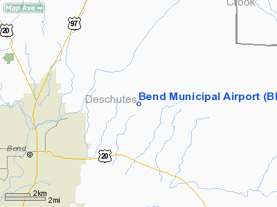
Bend Municipal Airport (ICAO: KBDN, FAA LID: BDN) is a city-owned, public-use airport located 5 nautical miles (9 km; 6 mi) northeast of the central business district of Bend, a city in Deschutes County, Oregon, United States. This airport is included in the FAA's National Plan of Integrated Airport Systems for 2009–2013, which categorizes it as a general aviation facility. Bend serves as the home to Cessna Aircraft (formerly Columbia Aircraft) and Epic Aircraft.
Although most U.S. airports use the same three-letter location identifier for the FAA and IATA, this airport is assigned BDN by the FAA but has no designation from the IATA (which assigned BDN to Talhar Airport in Badin, Pakistan). History
Located on approximately 415 acres (1.68 km) five miles (8 km) northeast of the City of Bend, Oregon, the Bend Municipal Airport traces its history back to 1942. A group of patriotic Bend citizens banded together to deed a small piece of farmland to the City of Bend for the express purpose that a municipally owned and operated landing strip be established. The site was developed and used for pilot training through World War II. Following the war, the airstrip was maintained by the City of Bend for continued civil use, where it experienced slow growth throughout the 1950s and 1960s.
By the 1970s, it was clear that the Bend Municipal Airport was becoming a significant element of the transportation infrastructure for Central Oregon and, in 1979, development of a comprehensive Airport Master Plan was undertaken. This plan established much of the direction for development at the airport and forecast significant growth in activity at the Bend Airport. This early Master Plan, however, was completed while General Aviation was booming across the country. A downturn in the general economy affected General Aviation in the 1980s and through the early 1990s, and as a result, the forecast growth in demand at the airport did not materialize. That all changed by the late 1990s, however, and General Aviation began a significant resurgence that continues today, along with tremendously increased business and corporate aviation travel into and out of Bend. Today, the Bend Municipal Airport stands poised to serve as the General Aviation and Corporate Aviation gateway to Central Oregon. Continued development of Cessna Aircraft, Epic Aircraft, Leading Edge Aviation, Precise Flight, and other growing tenants on the Airport have made a thriving aviation business park of the Bend Airport. In total, more than eighteen aviation related businesses are located on the airport employing more than 1000 people, making the Bend Municipal Airport one of the largest concentrations of family-wage jobs in the metropolitan Bend area. Over the next several years, a significant number of improvements are planned, including an Airport Master Plan Update and development of a full east side parallel taxiway, as well as more than 40 acres (160,000 m) of general aviation and corporate aviation facilities.
Facilities and aircraft
Bend Municipal Airport covers an area of 415 acres (168 ha) at an elevation of 3,460 feet (1,055 m) above mean sea level. It has one runway designated 16/34 with an asphalt surface measuring 5,200 by 75 feet (1,585 x 23 m) and a corresponding full parallel taxiway.
The Bend Municipal Airport is identified as a Category 2, High Activity Business and General Aviation airport by the Oregon Department of Aviation. For the 12-month period ending June 24, 2008, the airport had 50,100 aircraft operations, an average of 137 per day: 98% general aviation, 2% air taxi, and <1% military. At that time there were 199 aircraft based at this airport: 80% single-engine, 8% multi-engine, 2% jet, 4% helicopter, 4% glider and 2% ultralight. Bend, OR airport
The above content comes from Wikipedia and is published under free licenses – click here to read more.
Location & QuickFacts
| FAA Information Effective: | 2008-09-25 |
| Airport Identifier: | BDN |
| Airport Status: | Operational |
| Longitude/Latitude: | 121-12-00.8000W/44-05-40.4000N
-121.200222/44.094556 (Estimated) |
| Elevation: | 3460 ft / 1054.61 m (Surveyed) |
| Land: | 415 acres |
| From nearest city: | 5 nautical miles NE of Bend, OR |
| Location: | Deschutes County, OR |
| Magnetic Variation: | 19E (1980) |
Owner & Manager
| Ownership: | Publicly owned |
| Owner: | City Of Bend |
| Address: | Box 431
Bend, OR 97701 |
| Phone number: | 541-389-0258 |
| Manager: | Susan Palmeri |
| Address: | Box 431
Bend, OR 97701 |
| Phone number: | 541-389-0258 |
Airport Operations and Facilities
| Airport Use: | Open to public |
| Wind indicator: | Yes |
| Segmented Circle: | No |
| Control Tower: | No |
| Lighting Schedule: | DUSK-DAWN
ACTVT MIRL RY 16/34 - CTAF. |
| Beacon Color: | Clear-Green (lighted land airport) |
| Landing fee charge: | No |
| Sectional chart: | Klamath Falls |
| Region: | ANM - Northwest Mountain |
| Traffic Pattern Alt: | 1000 ft |
| Boundary ARTCC: | ZSE - Seattle |
| Tie-in FSS: | MMV - Mc Minnville |
| FSS on Airport: | No |
| FSS Toll Free: | 1-800-WX-BRIEF |
| NOTAMs Facility: | MMV (NOTAM-d service avaliable) |
| Federal Agreements: | NGSY |
Airport Communications
| CTAF: | 123.000 |
| Unicom: | 123.000 |
Airport Services
| Fuel available: | 100LLA |
| Airframe Repair: | MAJOR |
| Power Plant Repair: | MAJOR |
| Bottled Oxygen: | HIGH/LOW |
| Bulk Oxygen: | HIGH |
Runway Information
Runway 16/34
| Dimension: | 5200 x 75 ft / 1585.0 x 22.9 m |
| Surface: | ASPH, |
| Weight Limit: | Single wheel: 30000 lbs. |
| Edge Lights: | Medium |
| |
Runway 16 |
Runway 34 |
| Longitude: | 121-12-00.7737W | 121-12-00.8175W |
| Latitude: | 44-06-06.0905N | 44-05-14.7459N |
| Elevation: | 3403.00 ft | 3460.00 ft |
| Alignment: | 127 | 127 |
| Traffic Pattern: | Left | Left |
| Markings: | Non-precision instrument, Good Condition | Non-precision instrument, Good Condition |
| Runway End Identifier: | No | No |
| Obstruction: | 26 ft road, 956.0 ft from runway, 10 ft right of centerline, 29:1 slope to clear | 40 ft tree, 1298.0 ft from runway, 50 ft left of centerline, 27:1 slope to clear |
|
Radio Navigation Aids
| ID |
Type |
Name |
Ch |
Freq |
Var |
Dist |
| RD | NDB | Bodey | | 411.00 | 18E | 15.0 nm |
| DSD | VORTAC | Deschutes | 123X | 117.60 | 18E | 10.5 nm |
Remarks
- TWY PARALLEL TO RY 16/34 MKD BY REFLECTORS.
- CALM WIND RWY IS RWY 16
- NOISE ABATEMENT PROCEDURES IN EFFECT, CALL FBO AT (541) 388-0019
- EXISTED PRIOR TO 1959.
Images and information placed above are from
http://www.airport-data.com/airport/BDN/
We thank them for the data!
|
|


