 |
|
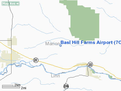
Location & QuickFacts
| FAA Information Effective: | 2008-09-25 |
| Airport Identifier: | 7OR2 |
| Airport Status: | Operational |
| Longitude/Latitude: | 122-40-47.3110W/44-49-22.4390N
-122.679809/44.822900 (Estimated) |
| Elevation: | 1160 ft / 353.57 m (Estimated) |
| Land: | 30 acres |
| From nearest city: | 3 nautical miles NW of Mehama, OR |
| Location: | Marion County, OR |
| Magnetic Variation: | 19E (1985) |
Owner & Manager
| Ownership: | Privately owned |
| Owner: | Roy Lee & Julia M Basl |
| Address: | 9020 Basl Hill Rd Se
Stayton, OR 97383 |
| Phone number: | 503-769-2504 |
| Manager: | Roy Lee Basl |
| Address: | 9020 Basl Hill Rd Se
Stayton, OR 97383 |
| Phone number: | 503-769-2504 |
Airport Operations and Facilities
| Airport Use: | Private |
| Wind indicator: | Yes |
| Segmented Circle: | No |
| Control Tower: | No |
| Lighting Schedule: | PHONE REQ
ACTIVATE LIRL 08/26 CALL 503-769-2504. |
| Landing fee charge: | No |
| Sectional chart: | Seattle |
| Region: | ANM - Northwest Mountain |
| Boundary ARTCC: | ZSE - Seattle |
| Tie-in FSS: | MMV - Mc Minnville |
| FSS on Airport: | No |
| FSS Toll Free: | 1-800-WX-BRIEF |
Runway Information
Runway 08/26
| Dimension: | 2000 x 50 ft / 609.6 x 15.2 m |
| Surface: | TURF, Poor Condition |
| Edge Lights: | Low |
| |
Runway 08 |
Runway 26 |
| Traffic Pattern: | Left | Left |
| Markings: | Nonstandard, Good Condition | , |
| Obstruction: | 25 ft pline, 4000.0 ft from runway | |
|
Radio Navigation Aids
| ID |
Type |
Name |
Ch |
Freq |
Var |
Dist |
| LWG | NDB | Lewisburg | | 225.00 | 18E | 28.2 nm |
| EU | NDB | Frakk | | 260.00 | 19E | 43.4 nm |
| LBH | NDB | Laker | | 332.00 | 20E | 44.1 nm |
| CBU | TACAN | Columbia | 029X | | 20E | 46.1 nm |
| CVO | VOR/DME | Corvallis | 101X | 115.40 | 18E | 32.7 nm |
| UBG | VOR/DME | Newberg | 121X | 117.40 | 21E | 34.3 nm |
| PDX | VOR/DME | Portland | 055X | 111.80 | 20E | 46.4 nm |
| EUG | VORTAC | Eugene | 076X | 112.90 | 20E | 48.2 nm |
| HIO | VOT | Portland-hillsboro | | 115.20 | | 44.6 nm |
| PDX | VOT | Portland Intl | | 111.00 | | 46.7 nm |
Remarks
- MUTIPLE USE AS PASTURE; LIVESTOCK ON RWY.
- RWY NOT LEVEL; DIP IN MIDDLE AND A DOG-LEG ON EAST END OF RWY.
- DUE TO CHANGING ELEVATION POSSIBLE TURBULANT WINDS IN AREA.
- COMMITTED LANDINGS. GO-AROUNDS DIFFICULT, RISING TERRAIN.
Images and information placed above are from
http://www.airport-data.com/airport/7OR2/
We thank them for the data!
| General Info
|
| Country |
United States
|
| State |
OREGON
|
| FAA ID |
7OR2
|
| Latitude |
44-49-22.439N
|
| Longitude |
122-40-47.311W
|
| Elevation |
1160 feet
|
| Near City |
MEHAMA
|
We don't guarantee the information is fresh and accurate. The data may
be wrong or outdated.
For more up-to-date information please refer to other sources.
|
|


