 |
|
Aurora State Airport
Wes Lematta Field |
| IATA: none – ICAO: KUAO – FAA LID: UAO |
| Summary |
| Airport type |
Public |
| Operator |
Oregon Department of Aviation |
| Serves |
Aurora, Oregon |
| Location |
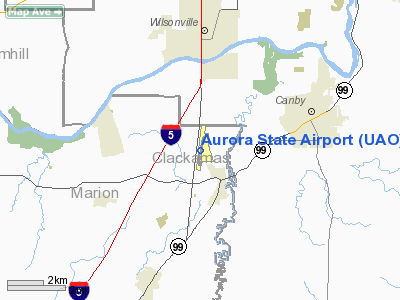
Marion County, near Aurora, Oregon |
| Elevation AMSL |
200 ft / 61 m |
| Coordinates |
45°14′50″N 122°46′12″W / 45.24722°N 122.77°W / 45.24722; -122.77 |
| Runways |
| Direction |
Length |
Surface |
| ft |
m |
| 17/35 |
5,004 |
1,525 |
Asphalt |
| Statistics (2000) |
| Aircraft operations |
73,895 |
| Based aircraft |
432 |
| Source: Federal Aviation Administration |
Boeing Vertol 234 C-FHFB (cn MJ005) During inspection at Columbia Helicopters Heliport adjacent to Aurora State Airport. Aurora State Airport (ICAO: KUAO, FAA LID: UAO) is a public airport located one mile (2 km) northwest of the central business district of Aurora, a city in Marion County, Oregon, United States. It is owned by the Oregon Department of Aviation.
Although most U.S. airports use the same three-letter location identifier for the FAA and IATA, Aurora State Airport is assigned UAO by the FAA but has no designation from the IATA.
Primarily a general aviation airport, Aurora has significant business aviation based at the field. In addition the airport serves as the home to two major aviation companies Van's Aircraft and Columbia Helicopters.
On May 26, 2009, the Oregon State Legislature passed a resolution identifying the airport as Wes Lematta Field at Aurora State Airport. The late Wes Lematta was the founder of Columbia Helicopters located on the northeastern corner of the field. Facilities and aircraft
Aurora State Airport covers an area of 144 acres (58 ha) which contains one asphalt paved runway (17/35) measuring 5,004 x 100 ft (1,525 x 30 m). For the 12-month period ending June 30, 2000, the airport had 73,895 aircraft operations, an average of 202 per day: 91% general aviation, 8% air taxi and <1% military. There are 432 aircraft based at this airport: 84% single engine, 7% multi-engine, 1% jet aircraft and 8% helicopters.
Three fixed base operators operate at the field: Aurora Aviation, Aurora Jet Center, and Willamette Aviation. Aurora Aviation and Willamette Aviation provide aircraft fuel services, flight instruction, aircraft rentals, and aircraft sales, while the Aurora Jet Center primarily provides aircraft refuelling services, hangars for corporate aircraft, and an executive lounge for private and corporate jet operations.
History
The airport was built by the United States Army Air Force about 1942, and was known as Aurora Flight Strip. It was an emergency landing airfield by Portland Army Air Base for military aircraft on training flights. It was closed after World War II, and was turned over for local government use by the War Assets Administration (WAA).
The above content comes from Wikipedia and is published under free licenses – click here to read more.
Location & QuickFacts
| FAA Information Effective: | 2008-09-25 |
| Airport Identifier: | UAO |
| Airport Status: | Operational |
| Longitude/Latitude: | 122-46-12.2000W/45-14-49.7000N
-122.770056/45.247139 (Estimated) |
| Elevation: | 200 ft / 60.96 m (Surveyed) |
| Land: | 144 acres |
| From nearest city: | 1 nautical miles NW of Aurora, OR |
| Location: | Marion County, OR |
| Magnetic Variation: | 18E (1995) |
Owner & Manager
| Ownership: | Publicly owned |
| Owner: | Oregon Dept Of Aviation |
| Address: | 3040 25th St Se
Salem, OR 97302-1125 |
| Phone number: | 503-378-4880 |
| Manager: | States Airports Mgr |
| Address: | 3040 25th St Se
Salem, OR 97302-1125 |
| Phone number: | 503-378-4880 |
Airport Operations and Facilities
| Airport Use: | Open to public |
| Wind indicator: | Yes |
| Segmented Circle: | Yes |
| Control Tower: | No |
| Lighting Schedule: | DUSK-DAWN
ACTVT VASI RYS 17 & 35 AND ODALS RY 17 - CTAF. MIRL RY 17/35 OPR DUSK-DAWN. |
| Beacon Color: | Clear-Green (lighted land airport) |
| Landing fee charge: | No |
| Sectional chart: | Seattle |
| Region: | ANM - Northwest Mountain |
| Traffic Pattern Alt: | 1000 ft |
| Boundary ARTCC: | ZSE - Seattle |
| Tie-in FSS: | MMV - Mc Minnville |
| FSS on Airport: | No |
| FSS Toll Free: | 1-800-WX-BRIEF |
| NOTAMs Facility: | UAO (NOTAM-d service avaliable) |
| Federal Agreements: | NGY |
Airport Communications
| CTAF: | 122.700 |
| Unicom: | 122.700 |
Airport Services
| Fuel available: | 100LLA |
| Airframe Repair: | MAJOR |
| Power Plant Repair: | MAJOR |
| Bottled Oxygen: | NONE |
| Bulk Oxygen: | HIGH |
Runway Information
Runway 17/35
| Dimension: | 5004 x 100 ft / 1525.2 x 30.5 m
RY 17/35 150 FT BLAST PAD AT SOUTH END. |
| Surface: | ASPH, Good Condition |
| Surface Treatment: | Saw-cut or plastic Grooved |
| Weight Limit: | Single wheel: 30000 lbs.
Dual wheel: 45000 lbs. |
| Edge Lights: | Medium |
| |
Runway 17 |
Runway 35 |
| Longitude: | 122-46-07.8283W | 122-46-16.5154W |
| Latitude: | 45-15-14.1668N | 45-14-25.1481N |
| Elevation: | 200.00 ft | 196.00 ft |
| Alignment: | 127 | 7 |
| ILS Type: | LOC/DME
| |
| Traffic Pattern: | Left | Left |
| Markings: | Precision instrument, Good Condition | Precision instrument, Good Condition |
| Crossing Height: | 40.00 ft | 40.00 ft |
| VASI: | 4-box on right side | 4-box on left side |
| Visual Glide Angle: | 3.50° | 3.00° |
| Approach lights: | ODALS | |
| Obstruction: | 30 ft tree, 540.0 ft from runway, 285 ft right of centerline, 11:1 slope to clear | 45 ft tree, 1300.0 ft from runway, 250 ft left of centerline, 24:1 slope to clear |
|
Radio Navigation Aids
| ID |
Type |
Name |
Ch |
Freq |
Var |
Dist |
| LBH | NDB | Laker | | 332.00 | 20E | 21.9 nm |
| PND | NDB | Banks | | 356.00 | 21E | 25.8 nm |
| LWG | NDB | Lewisburg | | 225.00 | 18E | 43.6 nm |
| CBU | TACAN | Columbia | 029X | | 20E | 21.6 nm |
| UBG | VOR/DME | Newberg | 121X | 117.40 | 21E | 10.9 nm |
| PDX | VOR/DME | Portland | 055X | 111.80 | 20E | 21.9 nm |
| BTG | VORTAC | Battle Ground | 113X | 116.60 | 21E | 31.0 nm |
| HIO | VOT | Portland-hillsboro | | 115.20 | | 19.2 nm |
| PDX | VOT | Portland Intl | | 111.00 | | 22.3 nm |
Remarks
- RY 35 CALM WIND RY.
- RY 17 +30 FT PLINE 2100 FT FM THLD; MKD BY BALLS.
- PARALLEL TWY 40 FT WIDE; MKD BY REFLECTORS ON BOTH SIDES.
Images and information placed above are from
http://www.airport-data.com/airport/UAO/
We thank them for the data!
| General Info
|
| Country |
United States
|
| State |
OREGON
|
| FAA ID |
UAO
|
| Latitude |
45-14-49.700N
|
| Longitude |
122-46-12.200W
|
| Elevation |
200 feet
|
| Near City |
AURORA
|
We don't guarantee the information is fresh and accurate. The data may
be wrong or outdated.
For more up-to-date information please refer to other sources.
|
|


