 |
|
| West Woodward Airport |
 |
| IATA: WWR – ICAO: KWWR |
| Summary |
| Airport type |
General Aviation |
| Owner |
City of Woodward |
| Operator |
Woodward, Oklahoma |
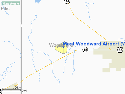
| Location |
Woodward County, near Woodward, Oklahoma |
| Elevation AMSL |
667.2 ft / m |
| Coordinates |
36°26′16.8″N 99°31′21.6″W / 36.438°N 99.522667°W / 36.438; -99.522667 |
| Runways |
| Direction |
Length |
Surface |
| ft |
m |
| 17/35 |
5,502 |
1,677 |
Asphalt |
| 5/23 |
2,500 |
762 |
Asphalt |
West Woodward Airport (IATA: WWR, ICAO: KWWR) is a general aviation airport, located 6 miles west of the City of Woodward, Oklahoma downtown business district. History
The airfield was built by the United States Army Air Forces in the fall of 1942 and early 1943 as an aircrew training field. Opened in March 1943 during World War II, the facility was known as Woodward Army Airfield and was assigned to the Second Air Force.
In the fall of 1943, the 409th Bombardment Group trained at the airfield with Douglas A-20 Havocs before being assigned overseas to the Ninth Air Force in England. The 408th Fighter-Bomber Group trained at the airfield with a variety of aircraft (A-24, A-26, P-40, and P-47) in the spring of 1944.
The airfield was returned to civil use at the end of the war.
Reactivated by the USAF Air Defense Command in 1952 as the Oklahoma City Air Force Station.
The 746th AC&W Squadron began operating a pair of AN/FPS-10 radars from this site in May 1952. An AN/FPS-6 height-finder radar was added in 1958. The AN/FPS-l0’s were phased out, with the last one being removed in 1962.
The ADC Oklahoma City Air Defense Sector operated from the facility between 1960-1966. In 1963 this was an ADC/FAA joint-use facility. The site used AN/FPS-67 search and AN/FPS-6 height-finder radars. In 1965 the search radar was upgraded to the AN/FPS-67B variant.
The Air Force deactivated the 746th Radar Squadron (SAGE) 8 September 1968. The FAA continues to operate the search radar today.
The above content comes from Wikipedia and is published under free licenses – click here to read more.
Location & QuickFacts
| FAA Information Effective: | 2008-09-25 |
| Airport Identifier: | WWR |
| Airport Status: | Operational |
| Longitude/Latitude: | 099-31-21.6000W/36-26-16.8000N
-99.522667/36.438000 (Estimated) |
| Elevation: | 2189 ft / 667.21 m (Surveyed) |
| Land: | 1310 acres |
| From nearest city: | 6 nautical miles W of Woodward, OK |
| Location: | Woodward County, OK |
| Magnetic Variation: | 08E (1985) |
Owner & Manager
| Ownership: | Publicly owned |
| Owner: | City Of Woodward |
| Address: | 1219 8th St
Woodward, OK 73801 |
| Phone number: | 580-256-2280 |
| Manager: | David Brown |
| Address: | 1301 Airpark Rd
Woodward, OK 73801 |
| Phone number: | 580-256-8286
OR 580-256-3915. |
Airport Operations and Facilities
| Airport Use: | Open to public |
| Wind indicator: | Yes |
| Segmented Circle: | Yes |
| Control Tower: | No |
| Lighting Schedule: | DUSK-DAWN |
| Beacon Color: | Clear-Green (lighted land airport) |
| Landing fee charge: | No |
| Sectional chart: | Wichita |
| Region: | ASW - Southwest |
| Boundary ARTCC: | ZKC - Kansas City |
| Tie-in FSS: | MLC - Mc Alester |
| FSS on Airport: | No |
| FSS Toll Free: | 1-800-WX-BRIEF |
| NOTAMs Facility: | WWR (NOTAM-d service avaliable) |
| Federal Agreements: | NGPRY |
Airport Communications
| CTAF: | 122.800 |
| Unicom: | 122.800 |
Airport Services
| Fuel available: | 100LLA |
| Airframe Repair: | MINOR |
| Power Plant Repair: | MINOR |
| Bottled Oxygen: | NONE |
| Bulk Oxygen: | NONE |
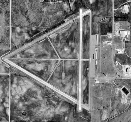
Runway Information
Runway 05/23
| Dimension: | 2500 x 60 ft / 762.0 x 18.3 m |
| Surface: | ASPH, Fair Condition |
| Pavement Class: | 3 /F/C/Y/T |
| Edge Lights: | Medium |
| |
Runway 05 |
Runway 23 |
| Longitude: | 099-31-48.2368W | 099-31-21.6207W |
| Latitude: | 36-26-20.9634N | 36-26-33.1530N |
| Elevation: | 2166.00 ft | 2164.00 ft |
| Alignment: | 60 | 127 |
| Traffic Pattern: | Left | Right |
| Markings: | Basic, Good Condition | Basic, Good Condition |
| Obstruction: | 36 ft trees, 700.0 ft from runway, 135 ft left of centerline, 13:1 slope to clear | , 50:1 slope to clear |
|
Runway 17/35
| Dimension: | 5502 x 100 ft / 1677.0 x 30.5 m |
| Surface: | CONC, Good Condition |
| Pavement Class: | 4 /R/B/X/T |
| Weight Limit: | Single wheel: 30000 lbs.
Dual wheel: 60000 lbs. |
| Edge Lights: | Medium |
| |
Runway 17 |
Runway 35 |
| Longitude: | 099-31-15.3305W | 099-31-15.8732W |
| Latitude: | 36-26-39.3238N | 36-25-44.9245N |
| Elevation: | 2161.00 ft | 2189.00 ft |
| Alignment: | 127 | 0 |
| Traffic Pattern: | Left | Left |
| Markings: | Non-precision instrument, Poor Condition
MARKINGS SEVERELY FADED. | Non-precision instrument, Poor Condition
MARKINGS SEVERELY FADED. |
| Crossing Height: | 37.00 ft | 44.00 ft |
| VASI: | 4-light PAPI on left side | 4-light PAPI on left side |
| Visual Glide Angle: | 3.00° | 3.00° |
|
Radio Navigation Aids
| ID |
Type |
Name |
Ch |
Freq |
Var |
Dist |
| OWU | NDB | West Woodward | | 329.00 | 08E | 0.2 nm |
| MDF | NDB | Mooreland/dcmsnd | | 284.00 | 08E | 16.2 nm |
| BFK | NDB | Buffalo | | 215.00 | 08E | 26.0 nm |
| AVK | NDB | Alva | | 203.00 | 08E | 45.9 nm |
| GAG | VORTAC | Gage | 103X | 115.60 | 10E | 18.2 nm |
Remarks
- ULTRALIGHT ACTIVITY ON & INVOF ARPT.
- CENTER TWY CLSD INDEFLY.
- PRE DATES THE ACT.
Images and information placed above are from
http://www.airport-data.com/airport/WWR/
We thank them for the data!
| General Info
|
| Country |
United States
|
| State |
OKLAHOMA
|
| FAA ID |
WWR
|
| Latitude |
36-26-12.129N
|
| Longitude |
099-31-15.591W
|
| Elevation |
2188 feet
|
| Near City |
WOODWARD
|
We don't guarantee the information is fresh and accurate. The data may
be wrong or outdated.
For more up-to-date information please refer to other sources.
|
|


