|
|
Coordinates: 36°11′54″N 095°53′17″W / 36.19833°N 95.88806°W / 36.19833; -95.88806
| Tulsa International Airport |
 |
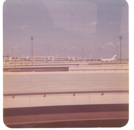
| Tulsa International Airport (1974 photograph) |
| IATA: TUL – ICAO: KTUL – FAA LID: TUL
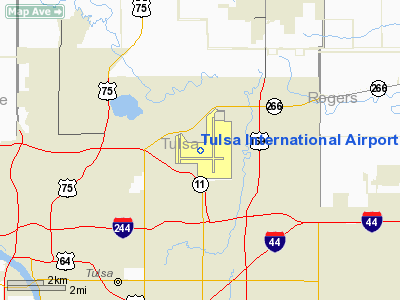
Location of the Tulsa International Airport
|
| Summary |
| Airport type |
Public |
| Owner |
City of Tulsa |
| Operator |
Tulsa Airport Authority |
| Serves |
Tulsa, Oklahoma |
| Elevation AMSL |
677 ft / 206 m |
| Website |
www.TulsaAirports.com |
| Runways |
| Direction |
Length |
Surface |
| ft |
m |
| 18L/36R |
9,999 |
3,048 |
Concrete |
| 18R/36L |
6,101 |
1,860 |
Asphalt |
| 8/26 |
7,376 |
2,248 |
Concrete |
| Statistics (2006) |
| Aircraft operations |
129,014 |
| Based aircraft |
167 |
| Source: Federal Aviation Administration |
Tulsa International Airport (IATA: TUL, ICAO: KTUL, FAA LID: TUL) is a city-owned public-use airport located five miles (8 km) northeast of the central business district of Tulsa, a city in Tulsa County, Oklahoma, United States.
The 138th Fighter Wing of the Air National Guard is based here. The airport is the global maintenance headquarters for American Airlines.
During WWII, Air Force Plant No. 3 was built on the southeast side of the airport, and Douglas Aircraft manufactured several types of aircraft there. After the war, this facility was used by Douglas (later McDonnell Douglas) and Rockwell International (later Boeing) for aircraft manufacturing, modification, repair, and research. IC Corporation now manufactures school buses in part of this building. Facilities and aircraft
Tulsa International Airport covers an area of 4,360 acres (1,764 ha) which contains three paved runways:
- Runway 18L/36R: 10,000 x 200 ft (3,048 x 61 m), Surface: Concrete
- Runway 18R/36L: 6,101 x 150 ft (1,860 x 46 m), Surface: Asphalt
- Runway 8/26: 7,376 x 150 ft (2,248 x 46 m), Surface: Concrete
For the 12-month period ending December 31, 2006, the airport had 129,014 aircraft operations, an average of 353 per day: 35% general aviation, 26% air taxi, 25% scheduled commercial and 13% military. There are 167 aircraft based at this airport: 32% single-engine , 22% multi-engine, 31% jet, 2% helicopter and 13% military.
American Airlines Maintenance Facility
Opened in June 1946, American’s Maintenance & Engineering Center at Tulsa International Airport is one of the largest and most sophisticated aviation maintenance facilities in the world . It is the headquarters for all Maintenance and Engineering activities at American Airlines worldwide, and is the maintenance base for the airline’s fleet of MD-80, B757, and B737 and some B767 and B777 aircraft – a combined total of nearly 600 airplanes. The Tulsa Base also performs all overhaul work on American’s Pratt and Whitney JT-8, and General Electric CF6-80 and CFM56 jet engines. Cutting-edge Base features include jet aircraft wheel and brake overhaul facilities and a composite repair center. With nearly 6,800 employees, more than 5,800 of whom are licensed aircraft and jet engine mechanics, American’s Tulsa Base is one of the largest private employers in Oklahoma . The Base occupies about 260 acres and 3,300,000 square feet (307,000 m) of maintenance “plant” at the Tulsa Airport. Each year, the base performs major overhaul work on about 80% of American’s fleet. It also does aircraft maintenance for other carriers on a contract basis.
Frequencies
Tower
- Tulsa Tower 121.2 Runways (18L-36R, 8-26) 118.7 (18R-36L)
- ATIS 124.9
- Ground 121.9
- Clearance Delivery 134.05
Runways
- ILS
- 36R 110.3
- 18L 109.7
- 18R 111.1
- 26 114.4 (DME)
- 8 114.4 (DME)
Airlines and destinations
Tulsa International Airport consists of two passenger concourses (A and B). The airport offers non-stop service to 16 domestic destinations/airports.
| Airlines |
Destinations |
Concourse |
| American Airlines |
Chicago-O'Hare, Dallas/Fort Worth, Miami |
A |
| American Eagle |
Chicago-O'Hare, Dallas/Fort Worth |
A |
| Continental Airlines |
Houston-Intercontinental |
A |
| Continental Express operated by ExpressJet Airlines |
Houston-Intercontinental, Newark |
A |
| Delta Air Lines |
Atlanta |
A |
| Delta Connection operated by Atlantic Southeast Airlines |
Atlanta |
A |
| Delta Connection operated by Pinnacle Airlines |
Detroit, Memphis, Minneapolis/St. Paul |
A |
| Delta Connection operated by SkyWest Airlines |
Minneapolis/St. Paul, Salt Lake City |
A |
| Southwest Airlines |
Dallas-Love, Denver, Houston-Hobby, Las Vegas, Phoenix, St. Louis |
B |
| United Airlines |
Denver |
B |
| United Express operated by ExpressJet Airlines |
Chicago-O'Hare |
B |
| United Express operated by SkyWest Airlines |
Chicago-O'Hare, Denver, Los Angeles |
B |
| United Express operated by Trans States Airlines |
Chicago-O'Hare |
B |
Cargo
In addition to cargo service provided by commercial air carriers, TUL is also served by:
- FedEx Express
- UPS Airlines
Military
The Air National Guard 138th Fighter Wing is based at Tulsa International Airport.
Airport management
- Jeff Mulder, A.A.E. – Director of Airports
- Alexis Higgins – Deputy Director of Marketing
- Jeff Hough – Deputy Director of Engineering and Facilities
- Ken Miller – Deputy Director of Operations
- Carl Remus – Deputy Director of Administration and Finance
Industrial Land Development
Tulsa Airport Authority, in 2008, has begun a new Industrial Land Development project. Aerospace is one of the Oklahoma's largest industry clusters with 400 companies that directly or indirectly employ more than 143,000 people with a payroll of $4.7 billion and an industrial output of $11.7 billion. Tulsa is ranked 8th nationally for the size of its aerospace engines manufacturing cluster and 20th for its defense-related cluster.
TUL's central location in the midwest is easily accessible by a multi-modal transportation network. With a total of 4,000 acres (16 km) and 14,000 on-airport employees, Tulsa is a large center of aviation activity. Six sites totaling over 700 acres (2.8 km) of real estate will be developed. Each of the sites can be divided in to smaller lots to meet any organization's individual needs.
World War II
Activated as a USAAC facility on 1 August 1939 as an advanced civilian pilot training school to supplement the Air Corps' few flying training schools. Spartan School of Aeronautics was selected for flight training. The Air Corps supplied students with training aircraft, flying clothes, textbooks, and equipment. The Air Corps also put a detachment at each school to supervise training. Flying training was performed with Fairchild PT-19s as the primary trainer. Also had several PT-17 Stearmans and a few P-40 Warhawks assigned. Spartan furnished instructors, training sites and facilities, aircraft maintenance, quarters, and mess halls.
Provided instruction until 4 August 1944 when inactivated with the drawdown of AAFTC's pilot training program.
The above content comes from Wikipedia and is published under free licenses – click here to read more.
Location & QuickFacts
| FAA Information Effective: | 2008-09-25 |
| Airport Identifier: | TUL |
| Airport Status: | Operational |
| Longitude/Latitude: | 095-53-17.2000W/36-11-54.2000N
-95.888111/36.198389 (Estimated) |
| Elevation: | 677 ft / 206.35 m (Surveyed) |
| Land: | 4360 acres |
| From nearest city: | 5 nautical miles NE of Tulsa, OK |
| Location: | Tulsa County, OK |
| Magnetic Variation: | 06E (1990) |
Owner & Manager
| Ownership: | Publicly owned |
| Owner: | City Of Tulsa |
| Address: | Tulsa Arpt Auth. Box 581838
Tulsa, OK 74158 |
| Phone number: | 918-838-5000 |
| Manager: | Jeff Mulder |
| Address: | 7777 E Apache
Tulsa, OK 74158 |
| Phone number: | 918-838-5000 |
Airport Operations and Facilities
| Airport Use: | Open to public |
| Wind indicator: | Yes |
| Segmented Circle: | No |
| Control Tower: | Yes |
| Lighting Schedule: | DUSK-DAWN |
| Beacon Color: | Clear-Green (lighted land airport) |
| Landing fee charge: | No |
| Sectional chart: | Dallas-ft Worth |
| Region: | ASW - Southwest |
| Boundary ARTCC: | ZKC - Kansas City |
| Tie-in FSS: | MLC - Mc Alester |
| FSS on Airport: | No |
| FSS Toll Free: | 1-800-WX-BRIEF |
| NOTAMs Facility: | TUL (NOTAM-d service avaliable) |
| Certification type/date: | I D S 05/1973 |
| Federal Agreements: | NGPRSY3 |
Airport Communications
Airport Services
| Fuel available: | 100LLA A1 B |
| Airframe Repair: | MAJOR |
| Power Plant Repair: | MAJOR |
| Bottled Oxygen: | HIGH/LOW |
| Bulk Oxygen: | HIGH/LOW |
Runway Information
Runway 08/26
| Dimension: | 7376 x 150 ft / 2248.2 x 45.7 m |
| Surface: | CONC, Good Condition |
| Surface Treatment: | Saw-cut or plastic Grooved
CENTER 140 FT GROOVED. |
| Weight Limit: | Single wheel: 75000 lbs.
Dual wheel: 200000 lbs.
Dual tandem wheel: 360000 lbs. |
| Edge Lights: | High |
| |
Runway 08 |
Runway 26 |
| Longitude: | 095-53-56.5093W | 095-52-26.5333W |
| Latitude: | 36-11-43.5539N | 36-11-44.2809N |
| Elevation: | 671.00 ft | 633.00 ft |
| Alignment: | 89 | 127 |
| Traffic Pattern: | Left | Left |
| Markings: | Non-precision instrument, Good Condition | Non-precision instrument, Good Condition |
| Arresting: | BAK14 | BAK14 |
| Crossing Height: | 52.00 ft | 57.00 ft |
| VASI: | 4-light PAPI on left side | 4-light PAPI on left side |
| Visual Glide Angle: | 3.00° | 3.00° |
| Runway End Identifier: | Yes | Yes |
| Obstruction: | 36 ft tree, 1775.0 ft from runway, 430 ft right of centerline, 43:1 slope to clear | , 50:1 slope to clear |
| Decleard distances: | Take off run available 7376.00 ft
Take off distance available 7376.00 ft
Actual stop distance available 7376.00 ft
Landing distance available 7376.00 ft
| Take off run available 7376.00 ft
Take off distance available 7376.00 ft
Actual stop distance available 7376.00 ft
Landing distance available 7376.00 ft
|
|
Runway 18L/36R
| Dimension: | 9999 x 200 ft / 3047.7 x 61.0 m |
| Surface: | CONC, Good Condition |
| Surface Treatment: | Saw-cut or plastic Grooved
CENTER 140 FT GROOVED. |
| Weight Limit: | Single wheel: 75000 lbs.
Dual wheel: 200000 lbs.
Dual tandem wheel: 400000 lbs. |
| Edge Lights: | High |
| |
Runway 18L |
Runway 36R |
| Longitude: | 095-52-52.7227W | 095-52-59.2863W |
| Latitude: | 36-12-50.1647N | 36-11-11.4305N |
| Elevation: | 626.00 ft | 644.00 ft |
| Alignment: | 127 | 3 |
| ILS Type: | ILS/DME
| ILS/DME
|
| Traffic Pattern: | Left | Left |
| Markings: | Precision instrument, Good Condition | Precision instrument, Good Condition |
| Arresting: | BAK14 | BAK14 |
| Crossing Height: | 53.00 ft | 57.00 ft |
| VASI: | 4-light PAPI on left side | 4-light PAPI on left side |
| Visual Glide Angle: | 2.75° | 3.00° |
| RVR Equipment: | touchdown, midfield, rollout | touchdown, midfield, rollout |
| Approach lights: | MALSR | ALSF2 |
| Centerline Lights: | Yes | Yes |
| Touchdown Lights: | No | Yes |
| Obstruction: | 41 ft tree, 1894.0 ft from runway, 47 ft right of centerline, 41:1 slope to clear | 29 ft tree, 1593.0 ft from runway, 127 ft right of centerline, 48:1 slope to clear |
| Decleard distances: | Take off run available 9999.00 ft
Take off distance available 9999.00 ft
Actual stop distance available 9999.00 ft
Landing distance available 9999.00 ft
| Take off run available 9999.00 ft
Take off distance available 9999.00 ft
Actual stop distance available 9999.00 ft
Landing distance available 9999.00 ft
|
|
Runway 18R/36L
| Dimension: | 6101 x 150 ft / 1859.6 x 45.7 m |
| Surface: | ASPH, Fair Condition |
| Surface Treatment: | Saw-cut or plastic Grooved
CENTER 140 FT GROOVED. |
| Weight Limit: | Single wheel: 60000 lbs.
Dual wheel: 100000 lbs. |
| Edge Lights: | High |
| |
Runway 18R |
Runway 36L |
| Longitude: | 095-53-56.7296W | 095-54-00.7347W |
| Latitude: | 36-12-25.9951N | 36-11-25.7549N |
| Elevation: | 634.00 ft | 677.00 ft |
| Alignment: | 127 | 3 |
| ILS Type: | ILS
| |
| Traffic Pattern: | Left | Left |
| Markings: | Precision instrument, Good Condition | Precision instrument, Good Condition |
| Crossing Height: | 63.00 ft | 50.00 ft |
| VASI: | 4-light PAPI on left side | 4-light PAPI on left side |
| Visual Glide Angle: | 2.75° | 3.00° |
| Runway End Identifier: | Yes | Yes |
| Obstruction: | 19 ft tree, 661.0 ft from runway, 159 ft left of centerline, 24:1 slope to clear | 10 ft road, 200.0 ft from runway, 419 ft left of centerline, 1:1 slope to clear
9 FT ROAD 0 DISTANCE 428 FT L |
| Decleard distances: | Take off run available 6101.00 ft
Take off distance available 6101.00 ft
Actual stop distance available 6101.00 ft
Landing distance available 6101.00 ft
| Take off run available 6101.00 ft
Take off distance available 6101.00 ft
Actual stop distance available 6101.00 ft
Landing distance available 6101.00 ft
|
|
Radio Navigation Aids
| ID |
Type |
Name |
Ch |
Freq |
Var |
Dist |
| DW | NDB | Owaso | | 375.00 | 06E | 6.6 nm |
| OWP | NDB | William Pogue | | 362.00 | 06E | 13.0 nm |
| TZO | NDB | Bristow | | 251.00 | 05E | 36.7 nm |
| TQH | NDB | Tahlequah | | 215.00 | 05E | 45.9 nm |
| MKO | NDB | Muskogee | | 306.00 | 06E | 46.6 nm |
| CUH | NDB | Cushing | | 242.00 | 05E | 46.9 nm |
| HET | NDB | Henryetta | | 267.00 | 04E | 48.1 nm |
| MEE | VOR | Davis | | 108.60 | 06E | 40.9 nm |
| GNP | VOR/DME | Glenpool | 043X | 110.60 | 06E | 17.1 nm |
| OKM | VOR/DME | Okmulgee | 096X | 114.90 | 08E | 30.4 nm |
| BVO | VOR/DME | Bartlesville | 126X | 117.90 | 08E | 38.7 nm |
| TUL | VORTAC | Tulsa | 091X | 114.40 | 08E | 4.9 nm |
| TUL | VOT | Tulsa Intl | | 109.00 | | 4.9 nm |
Remarks
- ACFT ARRESTING CABLE 1296 FT FM RY 36R; 1546 FT FM RY 18L; 983 FT FM RY 08 & 994 FT FM RY 26 THR END.
- TWY J2 LEAD OFF LGTS OTS INDEFLY.
- TWY DD CLSD INDEFLY.
- <4000FT BLACKTOP TRACK 1.5NM E RWY 26; DO NOT MISTAKE FOR RWY.
- RYS 08/26 & 18L/36R NSTD MARKINGS.
- RY 18L/36R SAFETY AREA REDUCED TO 400 FT.
- TWY CC CLSD INDEFLY.
- TAXILANES LZ, LA, & NN NOT VISIBLE FM ATCT.
- TWY L SOUTH OF TWY L5 NOT VISIBLE FM ATCT.
- THE FLWG AREAS ARE RSTRD TO WTS INDICATED: TWY JJ S-35; TWY M-2 S-35/D-52; TWY HH S-45/D-60; TWYS L & L4 S-45/D-60.
- NOISE ABATEMENT ALL RYS: CLIMB TO 3000 FT ASAP AFT TKOF.
- IREG WIND PATTERN AER 18R.
- TAXILANE QQ NOT VISIBLE FM ATCT.
Images and information placed above are from
http://www.airport-data.com/airport/TUL/
We thank them for the data!
| General Info
|
| Country |
United States
|
| State |
OKLAHOMA
|
| FAA ID |
TUL
|
| Latitude |
36-11-54.140N
|
| Longitude |
095-53-17.670W
|
| Elevation |
677 feet
|
| Near City |
TULSA
|
We don't guarantee the information is fresh and accurate. The data may
be wrong or outdated.
For more up-to-date information please refer to other sources.
|
|