 |
|
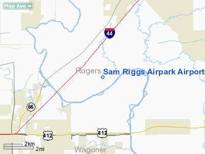
Sam Riggs Airpark Airport |
Location & QuickFacts
| FAA Information Effective: | 2008-09-25 |
| Airport Identifier: | K11 |
| Airport Status: | Closed Indefinitely |
| Longitude/Latitude: | 095-39-06.8000W/36-13-05.4000N
-95.651889/36.218167 (Estimated) |
| Elevation: | 580 ft / 176.78 m (Estimated) |
| Land: | 160 acres |
| From nearest city: | 7 nautical miles S of Claremore, OK |
| Location: | Rogers County, OK |
| Magnetic Variation: | 06E (1985) |
Owner & Manager
| Ownership: | Privately owned |
| Owner: | Crat Properties |
| Address: | P. O. Box 1782
Claremore, OK 74018 |
| Phone number: | 918-381-8900 |
| Manager: | Charles Polk |
| Address: | 10500 E. Airpark Rd.
Claremore, OK 74019 |
| Phone number: | 918-381-8900 |
Airport Operations and Facilities
| Airport Use: | Open to public |
| Wind indicator: | Yes |
| Segmented Circle: | No |
| Control Tower: | No |
| Sectional chart: | Kansas City |
| Region: | ASW - Southwest |
| Boundary ARTCC: | ZKC - Kansas City |
| Tie-in FSS: | MLC - Mc Alester |
| FSS on Airport: | No |
| FSS Toll Free: | 1-800-WX-BRIEF |
| NOTAMs Facility: | MLC (NOTAM-d service avaliable) |
Airport Communications
Runway Information
Runway 04/22
| Dimension: | 2760 x 35 ft / 841.2 x 10.7 m |
| Surface: | TURF, Poor Condition
RY COVERED IN TALL GRASS & WEEDS. SURFACE ROUGH.
RY COVERED IN TALL GRASS & WEEDS. SURFACE ROUGH. |
| |
Runway 04 |
Runway 22 |
| Longitude: | 095-39-14.4200W | 095-38-46.9400W |
| Latitude: | 36-12-55.8600N | 36-13-11.6400N |
| Traffic Pattern: | Right | Left |
| Obstruction: | 40 ft trees, 288.0 ft from runway, 7:1 slope to clear | 30 ft trees, 225.0 ft from runway, 7:1 slope to clear |
|
Runway 18/36
| Dimension: | 1550 x 110 ft / 472.4 x 33.5 m |
| Surface: | TURF, Poor Condition
RY COVERED IN TALL GRASS & WEEDS. SURFACE ROUGH.
RY COVERED IN TALL GRASS & WEEDS. SURFACE ROUGH. |
| |
Runway 18 |
Runway 36 |
| Traffic Pattern: | Left | Left |
| Obstruction: | 48 ft tree, 50 ft right of centerline | 50 ft trees, 400.0 ft from runway, 8:1 slope to clear |
|
Radio Navigation Aids
| ID |
Type |
Name |
Ch |
Freq |
Var |
Dist |
| DW | NDB | Owaso | | 375.00 | 06E | 12.1 nm |
| OWP | NDB | William Pogue | | 362.00 | 06E | 24.5 nm |
| TQH | NDB | Tahlequah | | 215.00 | 05E | 36.0 nm |
| MKO | NDB | Muskogee | | 306.00 | 06E | 41.5 nm |
| TZO | NDB | Bristow | | 251.00 | 05E | 46.2 nm |
| MEE | VOR | Davis | | 108.60 | 06E | 36.1 nm |
| GNP | VOR/DME | Glenpool | 043X | 110.60 | 06E | 23.6 nm |
| OKM | VOR/DME | Okmulgee | 096X | 114.90 | 08E | 33.2 nm |
| BVO | VOR/DME | Bartlesville | 126X | 117.90 | 08E | 41.0 nm |
| TUL | VORTAC | Tulsa | 091X | 114.40 | 08E | 6.7 nm |
| TUL | VOT | Tulsa Intl | | 109.00 | | 6.7 nm |
Remarks
- (ARPT STATUS) ARPT CLSD INDEFLY.
- E111 VFR OPNS ONLY.
Images and information placed above are from
http://www.airport-data.com/airport/K11/
We thank them for the data!
| General Info
|
| Country |
United States
|
| State |
OKLAHOMA
|
| FAA ID |
K11
|
| Latitude |
36-13-03.352N
|
| Longitude |
095-38-59.928W
|
| Elevation |
580 feet
|
| Near City |
CLAREMORE
|
We don't guarantee the information is fresh and accurate. The data may
be wrong or outdated.
For more up-to-date information please refer to other sources.
|
|


