 |
|
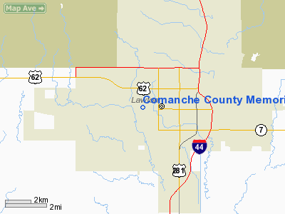
Comanche County Memorial Hospital Heliport |
Location & QuickFacts
| FAA Information Effective: | 2008-09-25 |
| Airport Identifier: | 18OK |
| Airport Status: | Operational |
| Longitude/Latitude: | 098-26-07.3000W/34-36-36.3300N
-98.435361/34.610092 (Estimated) |
| Elevation: | 1142 ft / 348.08 m (Surveyed) |
| Land: | 0 acres |
| From nearest city: | 0 nautical miles N of Lawton, OK |
| Location: | Comanche County, OK |
| Magnetic Variation: | 07E (1985) |
Owner & Manager
| Ownership: | Publicly owned |
| Owner: | Comanche Cty Mem Hospital |
| Address: | 3401 W Gore Blvd/ Po Box 129
Lawton, OK 73505 |
| Phone number: | 405-355-8620 |
| Manager: | Ron Jarvis |
| Address: | 3401 W Gore Blvd/ Po Box 129
Lawton, OK 73505 |
| Phone number: | 405-355-8620 |
Airport Operations and Facilities
| Airport Use: | Private
MEDICAL. |
| Wind indicator: | Yes |
| Segmented Circle: | No |
| Control Tower: | No |
| Lighting Schedule: | 24 HRS |
| Sectional chart: | Dallas-ft Worth |
| Region: | ASW - Southwest |
| Boundary ARTCC: | ZFW - Fort Worth |
| Tie-in FSS: | MLC - Mc Alester |
| FSS Toll Free: | 1-800-WX-BRIEF |
Runway Information
Helipad H1
| Dimension: | 50 x 50 ft / 15.2 x 15.2 m |
| Surface: | CONC, |
| |
Runway H1 |
Runway |
| Traffic Pattern: | Left | Left |
|
Radio Navigation Aids
| ID |
Type |
Name |
Ch |
Freq |
Var |
Dist |
| FSI | FAN MARKER | Trail | | | 09E | 10.4 nm |
| PFL | NDB | Post | | 308.00 | 08E | 1.6 nm |
| OFZ | NDB | Trail | | 388.00 | 09E | 10.4 nm |
| OLR | NDB | Chickasha | | 290.00 | 07E | 37.5 nm |
| VRT | NDB | Wilbarger | | 230.00 | 08E | 47.8 nm |
| SKB | NDB | Scotland | | 344.00 | 08E | 49.4 nm |
| SHP | TACAN | Sheppard | 045X | | 10E | 37.8 nm |
| LAW | VOR/DME | Lawton | 031X | 109.40 | 09E | 6.9 nm |
| DUC | VOR/DME | Duncan | 047X | 111.00 | 09E | 29.0 nm |
| HBR | VORTAC | Hobart | 055X | 111.80 | 10E | 34.6 nm |
| SPS | VORTAC | Wichita Falls | 074X | 112.70 | 10E | 38.3 nm |
| LTS | VORTAC | Altus | 035X | 109.80 | 08E | 41.4 nm |
Images and information placed above are from
http://www.airport-data.com/airport/18OK/
We thank them for the data!
| General Info
|
| Country |
United States
|
| State |
OKLAHOMA
|
| FAA ID |
18OK
|
| Latitude |
34-36-36.266N
|
| Longitude |
098-25-57.195W
|
| Elevation |
1142 feet
|
| Near City |
LAWTON
|
We don't guarantee the information is fresh and accurate. The data may
be wrong or outdated.
For more up-to-date information please refer to other sources.
|
|


