 |
|
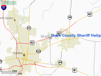
Stark County Sheriff Heliport |
Location & QuickFacts
| FAA Information Effective: | 2008-09-25 |
| Airport Identifier: | 5D1 |
| Airport Status: | Operational |
| Longitude/Latitude: | 081-18-29.3940W/40-50-23.2100N
-81.308165/40.839781 (Estimated) |
| Elevation: | 1135 ft / 345.95 m (Estimated) |
| Land: | 1 acres |
| From nearest city: | 4 nautical miles E of Canton, OH |
| Location: | Stark County, OH |
| Magnetic Variation: | 07W (1985) |
Owner & Manager
| Ownership: | Publicly owned |
| Owner: | Stark Co Comm |
| Address: | 4500 Atlantic Blvd Ne,
Canton, OH 44705 |
| Phone number: | 330-430-3800 |
| Manager: | Timothy A. Swanson |
| Address: | 4500 Atlantic Blvd Ne,
Canton, OH 44705 |
| Phone number: | 330-430-3800 |
Airport Operations and Facilities
| Airport Use: | Open to public |
| Wind indicator: | Yes |
| Segmented Circle: | No |
| Control Tower: | No |
| Landing fee charge: | No |
| Sectional chart: | Detroit |
| Region: | AGL - Great Lakes |
| Boundary ARTCC: | ZOB - Cleveland |
| Tie-in FSS: | CLE - Cleveland |
| FSS on Airport: | No |
| FSS Toll Free: | 1-800-WX-BRIEF |
| NOTAMs Facility: | CLE (NOTAM-d service avaliable) |
Airport Communications
Runway Information
Helipad H1
| Dimension: | 120 x 75 ft / 36.6 x 22.9 m |
| Surface: | ASPH, Good Condition |
| |
Runway H1 |
Runway |
| Traffic Pattern: | Left | Left |
|
Radio Navigation Aids
| ID |
Type |
Name |
Ch |
Freq |
Var |
Dist |
| AK | NDB | Akron | | 362.00 | 07W | 14.3 nm |
| TSO | NDB | Tolson | | 395.00 | 07W | 19.7 nm |
| MLR | NDB | Millersburg/dcmsnd | | 382.00 | 06W | 31.3 nm |
| CFX | NDB | Cadiz | | 239.00 | 07W | 38.7 nm |
| HBD | NDB | Hubbard | | 408.00 | 08W | 39.9 nm |
| UCP | NDB | Castle | | 272.00 | 09W | 42.0 nm |
| CL | NDB | Harri | | 344.00 | 07W | 42.2 nm |
| EZE | NDB | Engel | | 226.00 | 07W | 43.3 nm |
| AAU | NDB | Ashland | | 329.00 | 07W | 43.6 nm |
| BKL | NDB | Burke Lakefront | | 416.00 | 07W | 44.4 nm |
| BSV | VOR/DME | Briggs | 071X | 112.40 | 04W | 8.2 nm |
| ACO | VOR/DME | Akron | 091X | 114.40 | 04W | 16.8 nm |
| CTW | VOR/DME | Newcomerstown | 055X | 111.80 | 07W | 37.5 nm |
| CXR | VOR/DME | Chardon | 074X | 112.70 | 05W | 41.2 nm |
| TVT | VOR/DME | Tiverton | 112X | 116.50 | 03W | 43.8 nm |
| HLG | VOR/DME | Wheeling | 059X | 112.20 | 07W | 48.5 nm |
| DJB | VOR/DME | Dryer | 083X | 113.60 | 05W | 49.7 nm |
| YNG | VORTAC | Youngstown | 027X | 109.00 | 05W | 41.2 nm |
| EWC | VORTAC | Ellwood City | 105X | 115.80 | 08W | 49.9 nm |
| CAK | VOT | Akron/canton Regional | | 110.60 | | 7.6 nm |
| CLE | VOT | Cleveland | | 110.40 | | 42.1 nm |
Remarks
- INGRESS/EGRESS 270-090 DEG CLKWS FM PAD.
- VFR ONLY.
Images and information placed above are from
http://www.airport-data.com/airport/5D1/
We thank them for the data!
| General Info
|
| Country |
United States
|
| State |
OHIO
|
| FAA ID |
5D1
|
| Latitude |
40-50-23.210N
|
| Longitude |
081-18-29.394W
|
| Elevation |
1135 feet
|
| Near City |
CANTON
|
We don't guarantee the information is fresh and accurate. The data may
be wrong or outdated.
For more up-to-date information please refer to other sources.
|
|


