|
|
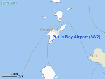
| Put-in-Bay Airport |
 |
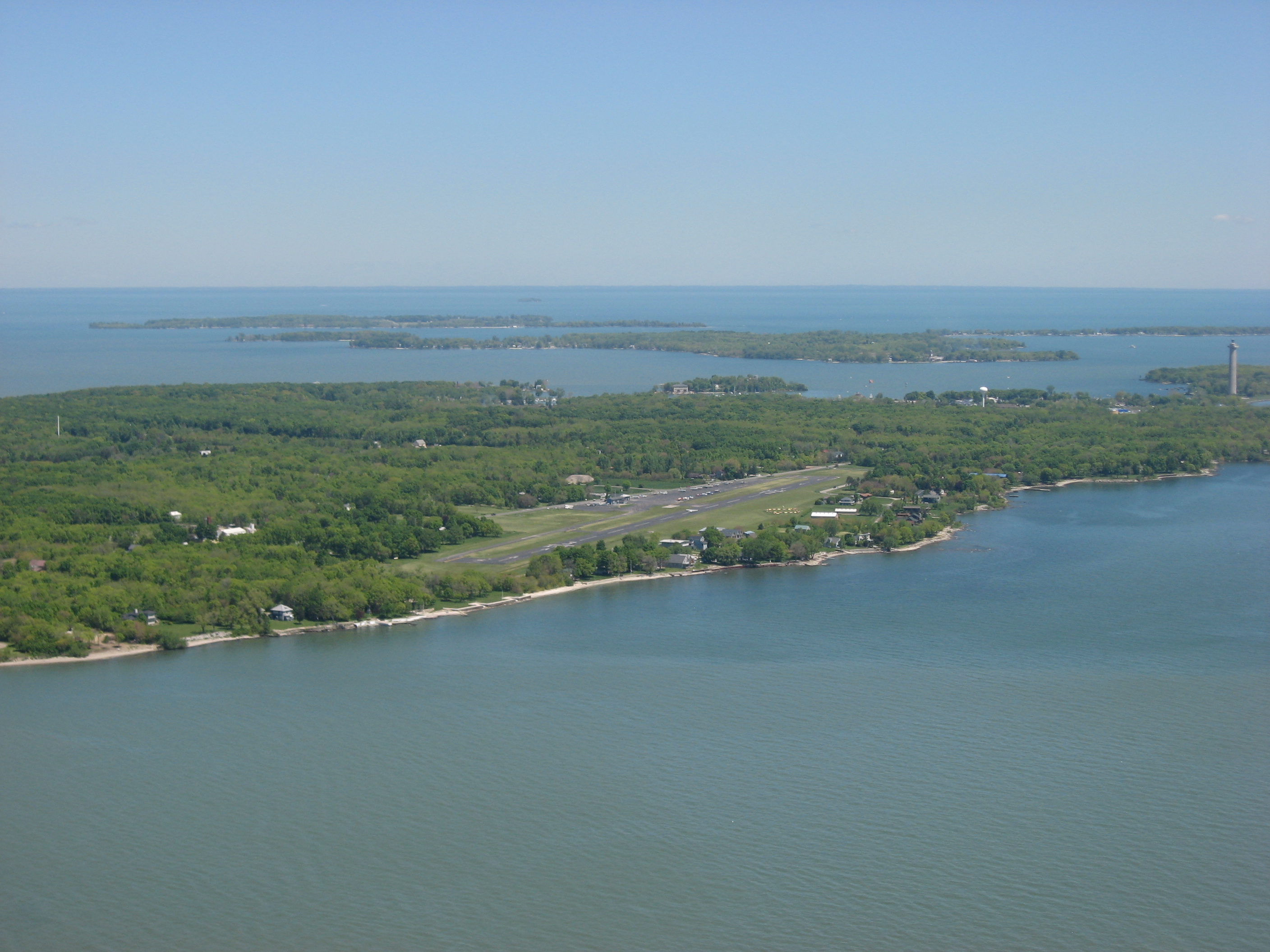
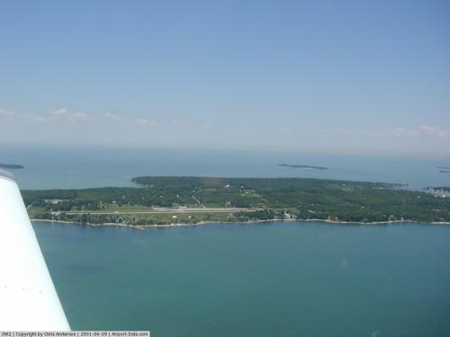
| Entering the approach pattern at Put-in-Bay Airport |
| IATA: none – ICAO: none – FAA LID: 3W2 |
| Summary |
| Airport type |
Public |
| Operator |
Put-in-Bay Township Port Authority |
| Serves |
South Bass Island |
| Location |
Put-in-Bay, Ohio |
| Elevation AMSL |
595 ft / 181.4 m |
| Coordinates |
41°38′12″N 82°49′42″W / 41.63667°N 82.82833°W / 41.63667; -82.82833Coordinates: 41°38′12″N 82°49′42″W / 41.63667°N 82.82833°W / 41.63667; -82.82833 |
| Runways |
| Direction |
Length |
Surface |
| ft |
m |
| 3/21 |
2,870 |
875 |
Asphalt |
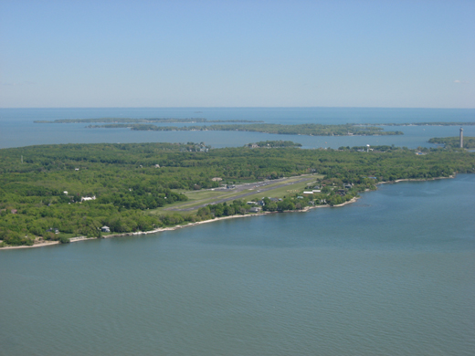
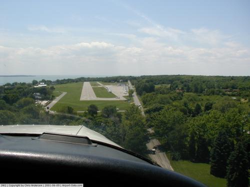
Put-in-Bay Airport (FAA LID: 3W2) is a public airport located in Put-in-Bay on South Bass Island in Ottawa County, Ohio, United States. The approach to Runway 21 is complicated by Perry's Victory and International Peace Memorial, which is almost exactly in line with the runway. The airport is located in the center of the southern half of the island and offers 2 runways.
Put-in-Bay's airport is open year round for arrivals and departures from dawn to dusk. Runways at the Put-in-Bay airport are modern and paved but not lighted so there are no departures after dusk. You may expect light turbulence on approach when winds exceed 10 knots. Be sure to remain at least 1000 feet from Perry's monument located 1.5 miles northeast of the field and having an elevation of 942 feet MSL.
There is no fuel service at the Put-in-Bay airport but may be purchased from two nearby airports, Erie-Ottawa Regional Airport (FAA LID: PCW) and Griffing Sandusky Airport (FAA LID: SKY) . The Put-in-Bay airport provides charter services, refreshments (vending) and rest rooms. Credit cards are accepted.
Airport Communications
CTAF/UNICOM: 122.8
WX AWOS-3 at PCW (7 nm S): 118.775 (419-734-9955)
Instrument Procedures
There are no published instrument procedures at 3W2.
The above content comes from Wikipedia and is published under free licenses – click here to read more.
 |
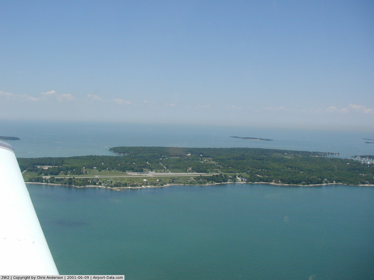
(Click on the photo to enlarge) |
 |
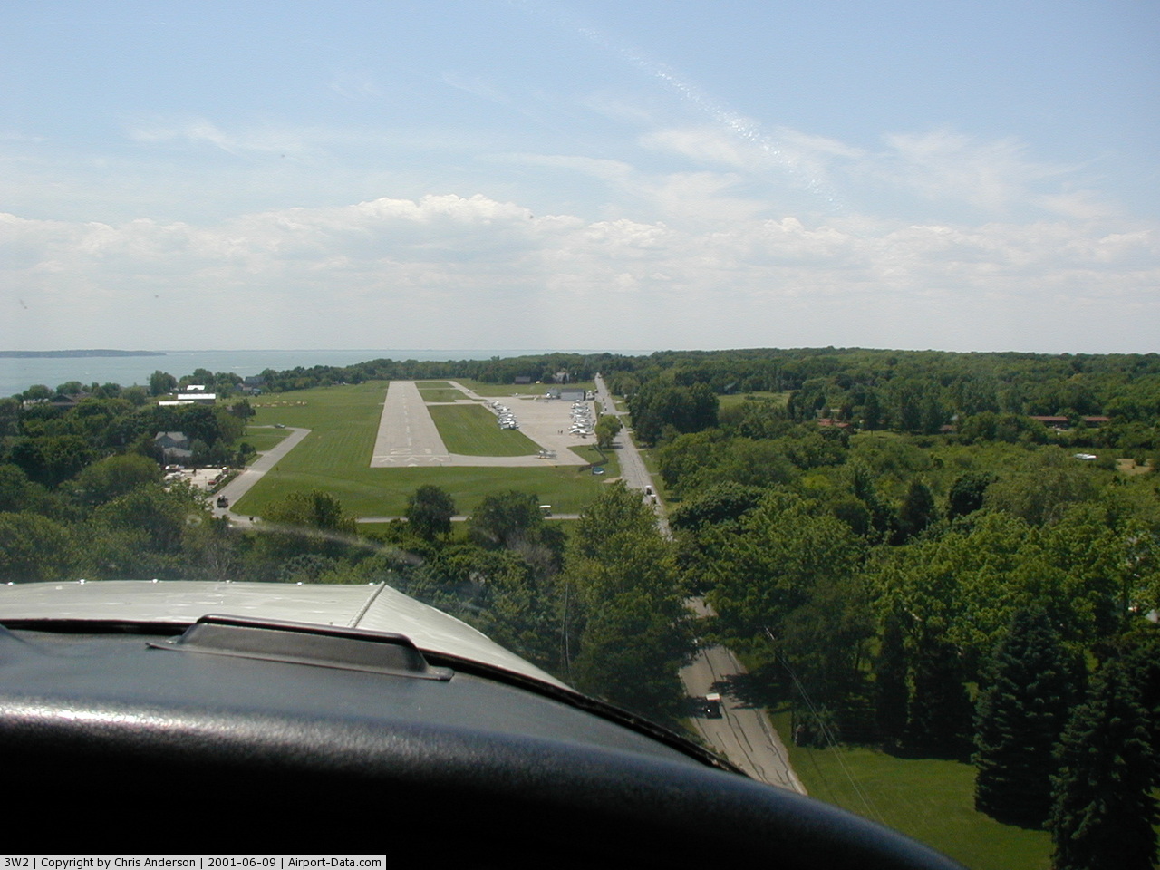
(Click on the photo to enlarge) |
Location & QuickFacts
| FAA Information Effective: | 2008-09-25 |
| Airport Identifier: | 3W2 |
| Airport Status: | Operational |
| Longitude/Latitude: | 082-49-42.0000W/41-38-12.0000N
-82.828333/41.636667 (Estimated) |
| Elevation: | 595 ft / 181.36 m (Surveyed) |
| Land: | 38 acres |
| From nearest city: | 1 nautical miles SW of Put In Bay, OH |
| Location: | Ottawa County, OH |
| Magnetic Variation: | 07W (2000) |
Owner & Manager
| Ownership: | Publicly owned |
| Owner: | Put In Bay Township Port Auth |
| Address: | Po Box 278
Put In Bay, OH 43456 |
| Phone number: | 419-285-3371 |
| Manager: | Monica Drake |
| Address: | Po Box 278
Put In Bay, OH 43456 |
| Phone number: | 419-285-3371 |
Airport Operations and Facilities
| Airport Use: | Open to public |
| Wind indicator: | Yes |
| Segmented Circle: | Yes |
| Control Tower: | No |
| Landing fee charge: | Yes
PARKING/RAMP FEES ARE COLLECTED FOR ALL PVT OR COML ACFT. ALL PILOTS ARE RQRD TO CHECK INTO THE ARPT OFFICE AT THE TIME OF ARRIVAL. NO TIE-DOWN ROPES ARE PRVDD; PLEASE BRING YOUR OWN SET. ALL ACFT ARE RQRD TO SHUT DOWN ENGINE(S) PRIOR TO ENPLANING/DEPLANING PAX. |
| Sectional chart: | Detroit |
| Region: | AGL - Great Lakes |
| Boundary ARTCC: | ZOB - Cleveland |
| Tie-in FSS: | CLE - Cleveland |
| FSS on Airport: | No |
| FSS Toll Free: | 1-800-WX-BRIEF |
| NOTAMs Facility: | CLE (NOTAM-d service avaliable) |
| Federal Agreements: | NGY |
Airport Communications
| CTAF: | 122.800 |
| Unicom: | 122.800 |
Airport Services
Runway Information
Runway 03/21
| Dimension: | 2870 x 75 ft / 874.8 x 22.9 m |
| Surface: | ASPH, Good Condition |
| |
Runway 03 |
Runway 21 |
| Longitude: | 082-49-52.2590W | 082-49-31.6803W |
| Latitude: | 41-38-00.1021N | 41-38-23.8863N |
| Elevation: | 592.00 ft | 594.00 ft |
| Traffic Pattern: | Right | Left |
| Markings: | Basic, Good Condition | Basic, Good Condition |
| Displaced threshold: | 452.00 ft | 657.00 ft |
| Runway End Identifier: | No | No |
| Centerline Lights: | No | No |
| Touchdown Lights: | No | No |
| Obstruction: | 50 ft trees, 380.0 ft from runway, 130 ft left of centerline, 3:1 slope to clear
RWY 03 APCH RATIO 7:1 TO DSPLCD THLD DUE TO +38 FT TREE 303 FT FM THLD 133 FT R. | 7 ft trees, 201.0 ft from runway, 120 ft right of centerline
RWY 21 APCH RATIO 9:1 TO DSPLCD THLD; DUE TO +50 FT TREES 497 FT FM THLD 175 FT R.
RWY 21 +7 FT FENCE O FT FM 120L TO 200 FT FM 120L AND +7 FT FENCE 100 FT FM 125 FT R TO 200 FT FM 110R. |
|
Radio Navigation Aids
| ID |
Type |
Name |
Ch |
Freq |
Var |
Dist |
| PCW | NDB | Port Clinton | | 423.00 | 06W | 7.3 nm |
| PT | NDB | Pelee Island | | 283.00 | 05W | 11.1 nm |
| RYS | NDB | Grosse Ile | | 419.00 | 06W | 31.5 nm |
| TII | NDB | Tiffin | | 269.00 | 05W | 36.6 nm |
| FZI | NDB | Fostoria | | 379.00 | 05W | 37.1 nm |
| G | NDB | Golf | | 398.00 | 05W | 37.8 nm |
| QG | NDB | Windsor | | 353.00 | 06W | 40.7 nm |
| CL | NDB | Harri | | 344.00 | 07W | 42.8 nm |
| VQ | NDB | Cargl | | 230.00 | 05W | 43.6 nm |
| AAU | NDB | Ashland | | 329.00 | 07W | 48.1 nm |
| TOL | TACAN | Toledo | 072X | | 05W | 43.7 nm |
| SKY | VOR/DME | Sandusky | 029X | 109.20 | 04W | 14.4 nm |
| DJB | VOR/DME | Dryer | 083X | 113.60 | 05W | 34.4 nm |
| YQG | VOR/DME | Windsor | 085X | 113.80 | 06W | 36.9 nm |
| VWV | VOR/DME | Waterville | 078X | 113.10 | 02W | 38.1 nm |
| DXO | VOR/DME | Detroit | 081X | 113.40 | 06W | 42.2 nm |
| CRL | VORTAC | Carleton | 104X | 115.70 | 03W | 37.5 nm |
| MFD | VORTAC | Mansfield | 025X | 108.80 | 03W | 47.4 nm |
| DTW | VOT | Detroit Met Wayne | | 109.80 | | 42.9 nm |
| CLE | VOT | Cleveland | | 110.40 | | 46.1 nm |
| DET | VOT | Detroit City | | 111.60 | | 46.9 nm |
| YIP | VOT | Willow Run | | 112.00 | | 47.5 nm |
Remarks
- EXPC MDT TURBC ON DEP/APCH WHEN WIND EXCEEDS 10 KT.
- ACFT LNDG RY 21 OR DEP RY 03 STAY 1000 FT CLEAR OF PERRY'S MONUMENT 352 FT AGL/942 FT MSL 1-1/2 MILES NE OF ARPT.
- ACFT OPNS PROHIBITED DUSK-DAWN.
- NO TGL; NO STUDENT TRAINING.
- IN OPERATION PRIOR TO 1959.
Images and information placed above are from
http://www.airport-data.com/airport/3W2/
We thank them for the data!
| General Info
|
| Country |
United States
|
| State |
OHIO
|
| FAA ID |
3W2
|
| Latitude |
41-38-12.000N
|
| Longitude |
082-49-42.000W
|
| Elevation |
595 feet
|
| Near City |
PUT IN BAY
|
We don't guarantee the information is fresh and accurate. The data may
be wrong or outdated.
For more up-to-date information please refer to other sources.
|
|