 |
|
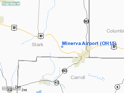
Location & QuickFacts
| FAA Information Effective: | 2008-09-25 |
| Airport Identifier: | OH15 |
| Airport Status: | Operational |
| Longitude/Latitude: | 081-08-39.3640W/40-44-45.2130N
-81.144268/40.745892 (Estimated) |
| Elevation: | 1080 ft / 329.18 m (Estimated) |
| Land: | 11 acres |
| From nearest city: | 3 nautical miles NW of Minerva, OH |
| Location: | Stark County, OH |
| Magnetic Variation: | 07W (1985) |
Owner & Manager
| Ownership: | Privately owned |
| Owner: | Minerva Flying Assoc |
| Address: | 14785. Freed St., S.e
Minerva, OH 44657
RESIDENCE OF JIM DENNING, TREAS. |
| Phone number: | 216-862-2091 |
| Manager: | James P. Denning |
| Address: | 14785.freed St., S.e.
Minerva, OH 44657 |
| Phone number: | 216-862-2091 |
Airport Operations and Facilities
| Airport Use: | Private |
| Wind indicator: | Yes |
| Segmented Circle: | No |
| Control Tower: | No |
| Lighting Schedule: | DUSK-DAWN |
| Landing fee charge: | No |
| Sectional chart: | Detroit |
| Region: | AGL - Great Lakes |
| Boundary ARTCC: | ZOB - Cleveland |
| Tie-in FSS: | CLE - Cleveland |
| FSS on Airport: | No |
| FSS Toll Free: | 1-800-WX-BRIEF
OR LOCAL CALL 494-5870. |
Airport Services
| Airframe Repair: | NONE |
| Power Plant Repair: | NONE |
| Bottled Oxygen: | NONE |
| Bulk Oxygen: | NONE |
Runway Information
Runway 01/19
| Dimension: | 2500 x 104 ft / 762.0 x 31.7 m |
| Surface: | TURF, |
| Edge Lights: | Low
RWY LGTS ON EAST SIDE OF RWY ONLY; 1600' OF RWY LGTD; SOUTH 900' OF RWY UNLGTD. |
| |
Runway 01 |
Runway 19 |
| Longitude: | 081-08-43.4200W | 081-08-35.2900W |
| Latitude: | 40-44-33.2500N | 40-44-57.1600N |
| Elevation: | 1080.00 ft | 1080.00 ft |
| Traffic Pattern: | Left | Left |
| Markings: | None, | None, |
| Runway End Identifier: | No | No |
| Centerline Lights: | No | No |
| Touchdown Lights: | No | No |
| Obstruction: | 35 ft pline, 125.0 ft from runway, 50 ft right of centerline, 4:1 slope to clear | 50 ft ant, 600.0 ft from runway, 60 ft right of centerline, 12:1 slope to clear |
|
Radio Navigation Aids
| ID |
Type |
Name |
Ch |
Freq |
Var |
Dist |
| TSO | NDB | Tolson | | 395.00 | 07W | 11.4 nm |
| AK | NDB | Akron | | 362.00 | 07W | 22.4 nm |
| CFX | NDB | Cadiz | | 239.00 | 07W | 31.2 nm |
| MLR | NDB | Millersburg/dcmsnd | | 382.00 | 06W | 35.4 nm |
| HBD | NDB | Hubbard | | 408.00 | 08W | 37.0 nm |
| UCP | NDB | Castle | | 272.00 | 09W | 37.1 nm |
| BSV | VOR/DME | Briggs | 071X | 112.40 | 04W | 13.1 nm |
| ACO | VOR/DME | Akron | 091X | 114.40 | 04W | 21.9 nm |
| CTW | VOR/DME | Newcomerstown | 055X | 111.80 | 07W | 34.6 nm |
| HLG | VOR/DME | Wheeling | 059X | 112.20 | 07W | 39.3 nm |
| AIR | VOR/DME | Bellaire | 118X | 117.10 | 07W | 46.3 nm |
| CXR | VOR/DME | Chardon | 074X | 112.70 | 05W | 46.4 nm |
| TVT | VOR/DME | Tiverton | 112X | 116.50 | 03W | 48.1 nm |
| YNG | VORTAC | Youngstown | 027X | 109.00 | 05W | 41.1 nm |
| EWC | VORTAC | Ellwood City | 105X | 115.80 | 08W | 42.7 nm |
| MMJ | VORTAC | Montour | 057X | 112.00 | 08W | 46.0 nm |
| CAK | VOT | Akron/canton Regional | | 110.60 | | 17.0 nm |
Remarks
- RWY COND GOOD WITH TURF SLOPING TO WEST; LAST 900' OF RWY 19 IS ROLLING.
- FLOODLIGHTS ON HGRS W SIDE OUTLINE STRIP AND OPER CONCURRENT W/RUNWAY LGTS ON E SIDE.
- FLOODLIGHT ON POLE WEST OF RWY 500' FM THR RWY 19.
- NIGHT LANDINGS NOT RECOMMENDED.
- VFR OPNS ONLY
Images and information placed above are from
http://www.airport-data.com/airport/OH15/
We thank them for the data!
| General Info
|
| Country |
United States
|
| State |
OHIO
|
| FAA ID |
OH15
|
| Latitude |
40-44-45.213N
|
| Longitude |
081-08-39.364W
|
| Elevation |
1080 feet
|
| Near City |
MINERVA
|
We don't guarantee the information is fresh and accurate. The data may
be wrong or outdated.
For more up-to-date information please refer to other sources.
|
|


