 |
|
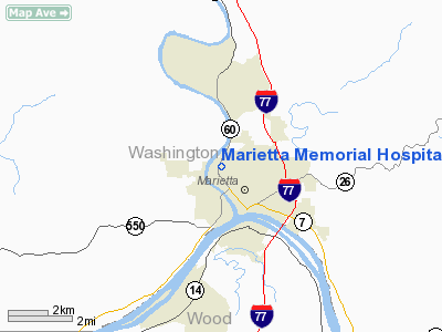
Marietta Memorial Hospital Heliport |
Location & QuickFacts
| FAA Information Effective: | 2008-09-25 |
| Airport Identifier: | OH85 |
| Airport Status: | Operational |
| Longitude/Latitude: | 081-27-51.4380W/39-25-54.2660N
-81.464288/39.431741 (Estimated) |
| Elevation: | 742 ft / 226.16 m (Estimated) |
| Land: | 0 acres |
| From nearest city: | 3 nautical miles NW of Marietta, OH |
| Location: | Washington County, OH |
| Magnetic Variation: | 06W (1990) |
Owner & Manager
| Ownership: | Privately owned |
| Owner: | Marietta Memorial Hospital |
| Address: | 401 Matthew St
Marietta, OH 45750 |
| Phone number: | 614-374-1723 |
| Manager: | Marietta Memorial Hospital |
| Address: | 401 Matthew St
Marietta, OH 45750 |
| Phone number: | 614-374-1723 |
Airport Operations and Facilities
| Airport Use: | Private
MEDICAL USE. |
| Wind indicator: | Yes |
| Segmented Circle: | No |
| Control Tower: | No |
| Sectional chart: | Cincinnati |
| Region: | AGL - Great Lakes |
| Boundary ARTCC: | ZID - Indianapolis |
| Tie-in FSS: | CLE - Cleveland |
| FSS on Airport: | No |
| FSS Toll Free: | 1-800-WX-BRIEF |
Runway Information
Helipad H1
| Dimension: | 32 x 25 ft / 9.8 x 7.6 m |
| Surface: | CONC,
ROOFTOP. |
| |
Runway H1 |
Runway |
| Traffic Pattern: | Left | Left |
|
Radio Navigation Aids
| ID |
Type |
Name |
Ch |
Freq |
Var |
Dist |
| PKB | FAN MARKER | Marietta Ohio | | | 03W | 3.6 nm |
| UGS | NDB | University | | 250.00 | 06W | 32.5 nm |
| HRA | NDB | Zanesville | | 204.00 | 06W | 35.5 nm |
| GAS | NDB | Gallipolis | | 420.00 | 07W | 48.5 nm |
| ZZV | VOR/DME | Zanesville | 051X | 111.40 | 06W | 36.5 nm |
| AIR | VOR/DME | Bellaire | 118X | 117.10 | 07W | 46.2 nm |
| CTW | VOR/DME | Newcomerstown | 055X | 111.80 | 07W | 47.9 nm |
| JPU | VORTAC | Parkersburg | 023X | 108.60 | 03W | 4.2 nm |
| HNN | VORTAC | Henderson | 106X | 115.90 | 03W | 48.4 nm |
Remarks
- OPNS ARE CONDUCTED FROM 300 DEGS TO 215 DEGS; AREA IS MARKED; WIND INDICATOR IS MAINTAINED.
Images and information placed above are from
http://www.airport-data.com/airport/OH85/
We thank them for the data!
| General Info
|
| Country |
United States
|
| State |
OHIO
|
| FAA ID |
OH85
|
| Latitude |
39-25-54.266N
|
| Longitude |
081-27-51.438W
|
| Elevation |
742 feet
|
| Near City |
MARIETTA
|
We don't guarantee the information is fresh and accurate. The data may
be wrong or outdated.
For more up-to-date information please refer to other sources.
|
|


