 |
|
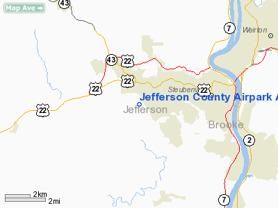
Jefferson County Airpark Airport |
Location & QuickFacts
| FAA Information Effective: | 2008-09-25 |
| Airport Identifier: | 2G2 |
| Airport Status: | Operational |
| Longitude/Latitude: | 080-42-00.2810W/40-21-33.9950N
-80.700078/40.359443 (Estimated) |
| Elevation: | 1196 ft / 364.54 m (Surveyed) |
| Land: | 170 acres |
| From nearest city: | 4 nautical miles W of Steubenville, OH |
| Location: | Jefferson County, OH |
| Magnetic Variation: | 08W (2000) |
Owner & Manager
| Ownership: | Publicly owned |
| Owner: | Jefferson Co Commissioners |
| Address: | P.o. Box 383
Steubenville, OH 43952 |
| Phone number: | 740-283-8500 |
| Manager: | Walter Dunn |
| Address: | Box 2104 Fernwood Rd
Wintersville, OH 43952 |
| Phone number: | 740-264-5388 |
Airport Operations and Facilities
| Airport Use: | Open to public |
| Wind indicator: | Yes |
| Segmented Circle: | Yes |
| Control Tower: | No |
| Lighting Schedule: | DUSK-DAWN
ACTVT MIRL RY 14/32; REIL RY 32 - CTAF. |
| Beacon Color: | Clear (unlighted land airport) |
| Landing fee charge: | No |
| Sectional chart: | Detroit |
| Region: | AGL - Great Lakes |
| Boundary ARTCC: | ZOB - Cleveland |
| Tie-in FSS: | CLE - Cleveland |
| FSS on Airport: | No |
| FSS Toll Free: | 1-800-WX-BRIEF |
| NOTAMs Facility: | CLE (NOTAM-d service avaliable) |
| Federal Agreements: | N |
Airport Communications
| CTAF: | 122.800 |
| Unicom: | 122.800 |
Airport Services
Runway Information
Runway 14/32
| Dimension: | 4400 x 60 ft / 1341.1 x 18.3 m |
| Surface: | ASPH, Good Condition |
| Weight Limit: | Single wheel: 7000 lbs. |
| Edge Lights: | Medium |
| |
Runway 14 |
Runway 32 |
| Longitude: | 080-42-23.5100W | 080-41-42.7820W |
| Latitude: | 40-21-51.9500N | 40-21-21.6210N |
| Elevation: | 1196.00 ft | 1192.00 ft |
| Alignment: | 127 | 127 |
| Traffic Pattern: | Left | Left |
| Markings: | Non-precision instrument, Good Condition | Non-precision instrument, Good Condition |
| VASI: | | 4-light PAPI on left side
OTS INDEFLY. |
| Runway End Identifier: | No | Yes |
| Centerline Lights: | No | No |
| Touchdown Lights: | No | No |
| Obstruction: | 32 ft trees, 1416.0 ft from runway, 419 ft right of centerline, 38:1 slope to clear | 64 ft trees, 1320.0 ft from runway, 17:1 slope to clear |
|
Radio Navigation Aids
| ID |
Type |
Name |
Ch |
Freq |
Var |
Dist |
| CFX | NDB | Cadiz | | 239.00 | 07W | 16.1 nm |
| TSO | NDB | Tolson | | 395.00 | 07W | 21.1 nm |
| PNU | NDB | Washington County | | 255.00 | 08W | 27.8 nm |
| UCP | NDB | Castle | | 272.00 | 09W | 41.9 nm |
| MKP | NDB | Mc Keesport | | 287.00 | 07W | 42.1 nm |
| HBD | NDB | Hubbard | | 408.00 | 08W | 48.3 nm |
| HLG | VOR/DME | Wheeling | 059X | 112.20 | 07W | 8.5 nm |
| AIR | VOR/DME | Bellaire | 118X | 117.10 | 07W | 21.3 nm |
| AGC | VOR/DME | Allegheny | 037X | 110.00 | 09W | 30.6 nm |
| CTW | VOR/DME | Newcomerstown | 055X | 111.80 | 07W | 36.4 nm |
| BSV | VOR/DME | Briggs | 071X | 112.40 | 04W | 40.5 nm |
| MMJ | VORTAC | Montour | 057X | 112.00 | 08W | 24.4 nm |
| EWC | VORTAC | Ellwood City | 105X | 115.80 | 08W | 35.8 nm |
| CAK | VOT | Akron/canton Regional | | 110.60 | | 47.6 nm |
Remarks
- DEER ON & INVOF ARPT.
- IN OPERN PRIOR TO FAA ACT.
Images and information placed above are from
http://www.airport-data.com/airport/2G2/
We thank them for the data!
| General Info
|
| Country |
United States
|
| State |
OHIO
|
| FAA ID |
2G2
|
| Latitude |
40-21-33.995N
|
| Longitude |
080-42-00.281W
|
| Elevation |
1194 feet
|
| Near City |
STEUBENVILLE
|
We don't guarantee the information is fresh and accurate. The data may
be wrong or outdated.
For more up-to-date information please refer to other sources.
|
|


