 |
|
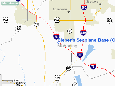
Bieber's Seaplane Base Airport |
Location & QuickFacts
| FAA Information Effective: | 2008-09-25 |
| Airport Identifier: | OI76 |
| Airport Status: | Operational |
| Longitude/Latitude: | 080-41-28.0000W/40-59-04.0000N
-80.691111/40.984444 (Estimated) |
| Elevation: | 1020 ft / 310.90 m (Estimated) |
| Land: | 100 acres |
| From nearest city: | 3 nautical miles NW of North Lima, OH |
| Location: | Mahoning County, OH |
| Magnetic Variation: | 08W (1995) |
Owner & Manager
| Ownership: | Privately owned |
| Owner: | Orville/curtis/william Bieber |
| Address: | 2301 W. Western Reserve Rd.
Canfield, OH 44406 |
| Phone number: | 330-758-1233 |
| Manager: | Orville/curtis/william Bieber |
| Address: | 2301 W. Western Reserve Rd.
Canfield, OH 44406 |
| Phone number: | 330-758-1233 |
Airport Operations and Facilities
| Airport Use: | Private |
| Wind indicator: | Yes |
| Segmented Circle: | No |
| Control Tower: | No |
| Sectional chart: | Detroit |
| Region: | AGL - Great Lakes |
| Boundary ARTCC: | ZOB - Cleveland |
| Tie-in FSS: | CLE - Cleveland |
| FSS on Airport: | No |
| FSS Toll Free: | 1-800-WX-BRIEF |
Airport Services
Runway Information
Runway 09/27
| Dimension: | 3000 x 85 ft / 914.4 x 25.9 m |
| Surface: | TURF, |
| |
Runway 09 |
Runway 27 |
| Traffic Pattern: | Left | Left |
| Obstruction: | 50 ft trees, 200.0 ft from runway | 40 ft pole, 1700.0 ft from runway |
|
Runway 18/36
| Dimension: | 2100 x 1500 ft / 640.1 x 457.2 m |
| Surface: | WATER, |
| |
Runway 18 |
Runway 36 |
| Traffic Pattern: | Left | Left |
| Obstruction: | 40 ft pole, 500.0 ft from runway | |
|
Radio Navigation Aids
| ID |
Type |
Name |
Ch |
Freq |
Var |
Dist |
| HBD | NDB | Hubbard | | 408.00 | 08W | 12.4 nm |
| UCP | NDB | Castle | | 272.00 | 09W | 12.7 nm |
| TSO | NDB | Tolson | | 395.00 | 07W | 30.9 nm |
| AK | NDB | Akron | | 362.00 | 07W | 32.0 nm |
| CFX | NDB | Cadiz | | 239.00 | 07W | 47.3 nm |
| FKL | VOR | Franklin | | 109.60 | 06W | 46.6 nm |
| ACO | VOR/DME | Akron | 091X | 114.40 | 04W | 24.3 nm |
| BSV | VOR/DME | Briggs | 071X | 112.40 | 04W | 36.7 nm |
| CXR | VOR/DME | Chardon | 074X | 112.70 | 05W | 38.5 nm |
| HLG | VOR/DME | Wheeling | 059X | 112.20 | 07W | 43.9 nm |
| JFN | VOR/DME | Jefferson | 099X | 115.20 | 05W | 46.7 nm |
| YNG | VORTAC | Youngstown | 027X | 109.00 | 05W | 20.8 nm |
| EWC | VORTAC | Ellwood City | 105X | 115.80 | 08W | 23.8 nm |
| MMJ | VORTAC | Montour | 057X | 112.00 | 08W | 37.5 nm |
| CAK | VOT | Akron/canton Regional | | 110.60 | | 34.3 nm |
Remarks
- PRVDD 20:1 APCH CLNC OVER OBSTNS; COMPLIANCE WITH PART 91.115 RIGHT-OF-WAY RULES: WATER OPNS; LOCATE WINDSOCK TO BE OBSERVED FM SFC & AIR; PLACE BALL MKRS ONR MEANS ON TELEPHONE LINES ALONG WESTERN RESERVE ROAD 500 FT N OF RY 18.
Images and information placed above are from
http://www.airport-data.com/airport/OI76/
We thank them for the data!
| General Info
|
| Country |
United States
|
| State |
OHIO
|
| FAA ID |
OI76
|
| Latitude |
40-59-04.000N
|
| Longitude |
080-41-28.000W
|
| Elevation |
1020 feet
|
| Near City |
NORTH LIMA
|
We don't guarantee the information is fresh and accurate. The data may
be wrong or outdated.
For more up-to-date information please refer to other sources.
|
|


